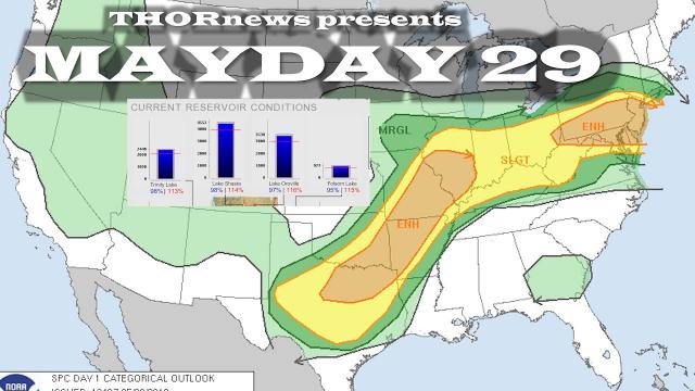
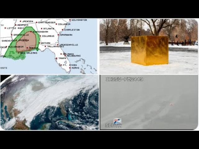
Tornadoes & River Flooding for Southeast today & Snow Sleet NE + Stormy March
Description
I need a miracle.
God bless everyone,
T
https://www.paypal.me/THORnews
@newTHOR on twitter
https://www.facebook.com/thornewsgo
Tshirts
https://hitthebuttonbaby.com/
the crankywxguy blog
http://www.stormhamster.com/entry/e030319.htm
mike's weather page
http://www.spaghettimodels.com/
models
https://www.tropicaltidbits.com/analysis/models/
a look at the Sun
https://sdo.gsfc.nasa.gov/data/
https://weather.com/storms/winter/news/2019-03-01-winter-storm-scott-snow-sierra-rockies-ozarks-northeast
Winter Storm Scott Spreading Snow From Plains and Midwest to the Northeast Through Early Monday
Winter Storm Scott will bring snow to the Plains, Midwest and Northeast through early Monday.
The snow will impact travel throughout those regions.
Snow that falls Sunday night could impact the Monday morning commute in the Northeast.
Winter Storm Scott will spread snow from the Plains and Midwest toward the Northeast through early Monday, including some East Coast cities that have seen relatively little snow recently.
Light to moderate snow was ongoing Monday morning from the mid-Mississippi Valley into the Ohio Valley. This snowfall will make travel slippery in parts of those regions.
Winter storm warnings and winter weather advisories have been issued by the National Weather Service from the central Plains into the Ohio Valley and Northeast. The winter storm warnings include Boston, Hartford, Providence, New York City, Philadelphia, and Baltimore.
Sunday-Early Monday
Snow will spread eastward from the Ozarks to the Ohio Valley and mid-Atlantic states by Sunday afternoon. Some freezing rain is possible early Sunday from eastern Oklahoma to southern Missouri and northern Arkansas.
This snow will then overspread most of the rest of the Northeast Sunday night.
The dividing line between rain and snow still remains somewhat uncertain, dependent on the exact track of surface low pressure in the East late Sunday.
Parts of the Interstate 95 corridor, including New York City and Philadelphia, may start out with rain before changing to snow Sunday evening. The snow could be heavy at times Sunday night.
Snow will linger into Monday morning from eastern Massachusetts into Maine.
The snow that falls in the Northeast Sunday night will impact the morning commute on Monday.
In addition to snow on the northern side, a threat of damaging wind gusts and a few tornadoes exists on Sunday in parts of the Southeast.
Snowfall totals in the mid-Mississippi Valley and Ohio Valley are forecast to be 3 inches or less in most locations.
A swath of 5 to 8 inches of snow is possible from the mountains of West Virginia to near the Interstate 95 Northeast corridor from north of Washington D.C. to New York City, Boston and coastal Maine.
Winter Storm Scott Recap
Winter Storm Scott was named late Friday afternoon with the expectation that naming criteria – that is winter storm warnings for 2 million people or 400,000 square kilometers – would be met during the weekend. Criteria was met Saturday afternoon as the warnings were added for Pittsburgh and the central Appalachians while remaining for parts of California's Sierra, much of Colorado and Kansas.
Winter Storm Scott entered the U.S. through northern and central California late on Mar. 1, then crossed through the Great Basin.
Snowfall totals through late Saturday evening:
California: 13 inches at Squaw Valley; 12 inches at Alpine Meadows
Colorado: 12 inches at the Hourglass Reservoir; 10.1 inches at Steamboat Springs
Utah: 7 inches at Laketown at nearly 6,000 feet