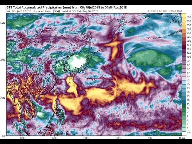
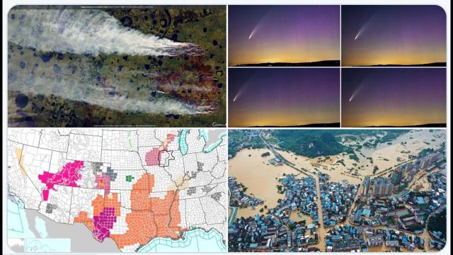
Heat & Fire & Rain & Floods USA - These Weather patterns are locked in for 2 weeks
Description
Me thinks the rainfall projection totals are way too low.
God Bless everyone,
T
https://www.paypal.me/THORnews
Tshirts
https://hitthebuttonbaby.com/
THORNEWS
PO BOX 35946
HOUSTON TEXAS
77235-5946
the excellent cranywxguy blog
http://www.stormhamster.com/entry/e073018b.htm
The Surf Master
http://www.dabuh.com
data site
http://www.spaghettimodels.com/
article on storms
https://weather.com/forecast/national/news/2018-07-26-unusual-midsummer-weather-pattern-wet-east
Localized Flooding Possible in the East This Week as Unusual Midsummer Weather Pattern Returns
An unusually deep southward plunge of the jet stream for midsummer will set up east of the Rockies this week.
This could contribute to more heavy rainfall in the South and East.
Localized flooding is possible, particularly in areas soaked by a similar weather pattern last week.
This week's weather pattern in the East will take on an unusual configuration for midsummer, potentially fueling more heavy rain and localized flooding.
A piece of energy riding through the jet stream will cause it to become amplified in a north-to-south fashion east of the Rockies early this week. In the summertime, the jet stream usually flows in a flatter west-to-east pattern near the Canadian border, so that's why this jet stream is unusual.
In tandem with blocking high pressure in the western Atlantic Ocean, the jet stream setup will help draw moisture from the Gulf of Mexico and the Atlantic into the South and East.
This means stormy conditions are likely from the Deep South into the Ohio Valley and parts of the East much of this week, and this could cause localized flooding.
Although a large number of states could see pockets of locally heavy rain throughout the week ahead, there is uncertainty when it comes to pinpointing locations with a heightened flood threat each day. Forecast guidance is indicating the Southeast states may see the heaviest rain totals through late week.
This week's weather pattern is somewhat similar to the one that fueled severe thunderstorms and heavy rainfall in portions of the South and East last week.
A swath from the Southeast coast to the mid-Atlantic was soaked by heavy rainfall. Parts of central Pennsylvania were particularly hard hit by flooding.
The downpours helped vault Baltimore (16.40 inches) and Harrisburg, Pennsylvania (11.66 inches), to their wettest Julys on record. Dunkirk, Maryland, received 16.55 inches of rain in about five days (July 21-25).
Given the mid-Atlantic is saturated, it will be vulnerable to flooding again should any of the heavier rainfall affect that region this week. Of course, there could be new areas that have a growing flood threat as well.
Another aspect of this week's weather pattern is that temperatures will stay relatively comfortable for this time of year in the Plains, Midwest and into the South.