Major Heat & Major Floods for the USA & Asia over next 2 weeks.
Description
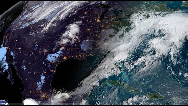
We're looking at some serious flooding possible all up and down the East coast and into the South over the next 2 weeks. Also, the Heat surges over the next week will be shattering some records. The worst weather is still to be found in Asia Pacific. They are in for some devastating Typhoons and flooding.
God bless everyone,
T
https://www.paypal.me/THORnews
Tshirts
https://hitthebuttonbaby.com/
THORNEWS
PO BOX 35946
HOUSTON TEXAS
77235-5946
the excellent cranywxguy blog
http://www.stormhamster.com/entry/e071818.htm
The Surf Master
http://www.dabuh.com
data site
http://www.spaghettimodels.com/
article on storm
https://www.accuweather.com/en/weather-news/will-a-weekend-rainstorm-signal-the-end-of-hot-summer-weather-in-the-northeast/70005527
Will a weekend rainstorm signal the end of hot summer weather in the Northeast?
A rainstorm moving up from the south will coincide with a shift in the jet stream and mark the beginning of an extended period of wet, humid conditions in the northeastern US that may last into August.
A storm is forecast to develop along the southern Atlantic coast and begin to unleash flooding rainfall late this week.
As the storm begins to move and gain some strength, it will force drenching rain northward along the mid-Atlantic coast and into New England this weekend.
While the rain may not be as intense as that on the Carolina and Georgia coasts, it can be heavy enough to cause a period of urban flooding.
Increasing winds along the coast are likely to create rough surf and strong rip currents.
Depending on the speed of the storm the heaviest rain may have already shifted to northern New England by Sunday afternoon.
People with outdoor plans or heading to the beach this weekend should be prepared for wet weather during part of their trip. The combination of rain and poor visibility may cause vehicle traffic to slow to a crawl at times. Airline delays due to a low cloud ceiling are likely as well at times.
The combination of rain and breezy conditions may seem more like a weak nor'easter from the spring or autumn in places such as Norfolk, Virginia; Ocean City, Maryland; Atlantic City, New Jersey; New York City and Boston.
Second storm to move in from the central US
At the same time farther west, a storm from the Plains will create a swath of rain and thunderstorms over the Midwest to the western slopes of the central Appalachians. Localized flooding downpours may also also occur with this storm.
Pittsburgh, Detroit, Cleveland, Cincinnati, Indianapolis, Chicago and Nashville, Tennessee, are also in line for some wet weather.
It is possible that a gap remains between both the coastal storm and the Midwest storm from central Virginia to central Pennsylvania and western and central New York state. If this occurs, little to no rain may fall in these areas through much of the weekend.
If the storms link up, then these in-between areas may be almost as wet as often as areas farther to the east and to the west by Sunday.
A link up is most likely Sunday night and Monday, when more of a mosaic of rain and embedded thunderstorms is likely throughout the Northeast.
Will a tropical storm develop?
There is a low chance the storm takes on characteristics of a tropical depression or tropical storm before moving inland over the Northeast later this weekend.
Since the feature will not be close to warm water for very long, that will limit the odds of tropical development, according to AccuWeather Senior Meteorologist Rob Miller.
It is possible that a sub-tropical storm, which has both tropical and non-tropical traits, may form.
Extended period of wet, humid conditions anticipated in the Northeast
As AccuWeather long-range meteorologists have been suggesting since early July, the overall weather pattern will become conducive for more rounds of wet weather in the Northeast and humid conditions along the Eastern Seaboard.
"The same southward dip in the jet stream that develops over the North Central states and frequently funnels unseasonably cool air into the Midwest is likely to often pull moisture northward along the Atlantic coast," according to AccuWeather Lead Long-Range Meteorologist Paul Pastelok.
As the pattern evolves, downpours that drenched areas on Tuesday may be a sample of what may occur in the coming weeks.
While the pattern may not bring rain every day everywhere, rainfall is likely to be above average, and people may get frustrated by the frequency of showers and thunderstorms as far as outdoor plans, sporting events and construction projects are concerned.
Enough rain is likely to fall in many areas to wipe out any rainfall deficit this summer.
Some incidents of flooding are likely, since it could rain hard enough long enough in part of the Northeast.
"The pattern is likely to have staying power through the end of July and may persist well into August," Pastelok said.


Comments