Danger! Alert! MAJOR RIVER FLOODING PROBLEMS for SOUTH & WEST USA through March
Description
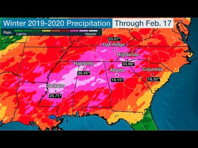
We've got multiple states with river flooding problems and the very floody spring season has yet to begin. This situation has potential to get extremely bad before you know it.
God bless everyone,
T
https://www.paypal.me/THORnews
@newTHOR on twitter
https://www.facebook.com/thornewsgo
Tshirts
https://hitthebuttonbaby.com/
the crankywxguy blog
http://www.stormhamster.com/entry/e030119.htm
mike's weather page
http://www.spaghettimodels.com/
models
https://www.tropicaltidbits.com/analysis/models/
a look at the Sun
https://sdo.gsfc.nasa.gov/data/
https://www.accuweather.com/en/weather-news/severe-weather-flood-risks-to-ramp-up-across-southern-us-on-sunday/70007589
https://www.accuweather.com/en/weather-news/severe-weather-flood-risks-to-ramp-up-across-southern-us-on-sunday/70007589
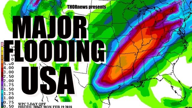
For the second consecutive weekend, the southern United States is bracing for potentially damaging thunderstorms and flash flooding on Sunday.
The same storm set to spread a swath of disruptive snow from the central Plains to the Northeast this weekend is expected to sweep downpours and thunderstorms across the South Sunday into Sunday night.
Sunday will start with rain and thunderstorms spreading over the lower Mississippi Valley.
While a few of these thunderstorms may produce hail, the risk for severe weather will ramp up by the afternoon.
A line of violent thunderstorms is expected to develop across northern Georgia, central Alabama, central and southern Mississippi and eastern Louisiana on Sunday.
"This line will march into the Southeast during the evening hours and will be capable of producing damaging winds, hail and flash flooding," according to AccuWeather Storm Warning Meteorologist Richard Schraeger.
In areas where the ground is overly saturated, the strong thunderstorm winds can more easily topple trees.
Schraeger is also concerned for a few tornadoes to briefly spin-up.
Cities at risk for the violent thunderstorms include Meridian and Hattiesburg, Mississippi; New Orleans; Birmingham, Montgomery and Mobile, Alabama; Atlanta, Augusta and Albany, Georgia; and Pensacola, Florida.
The violent thunderstorms may also track to near Greenville and Columbia, South Carolina, at the end of Sunday.
The worst of the severe weather may occur to the south and east of Columbus, Mississippi, which was devastated by an EF3 tornado last weekend.
Motorists planning to travel along stretches of interstates 10, 20, 55, 59, 75 and 85 are urged to remain vigilant of the severe weather danger.
The strongest winds can overturn high-profile vehicles. Downpours will dramatically reduce visibility and heighten the risk of vehicles hydroplaning when traveling at highway speeds.
Travel delays and hazards due to downpours will not be confined to areas at risk for severe weather in the South. Rain and thunderstorms are expected to also spread north of I-20 to around the I-40 corridor.