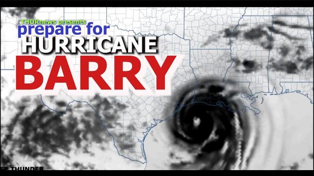
Alert! LOCK IT IN! Hurricane* Barry is a Harvey part 2 THREAT to Gulf of Mexico!
Description
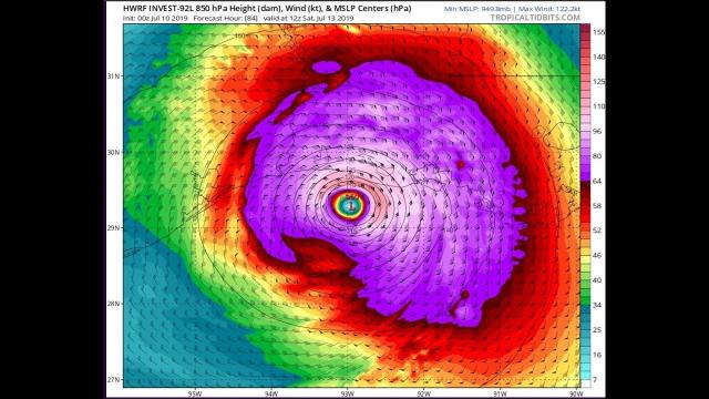
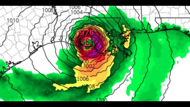
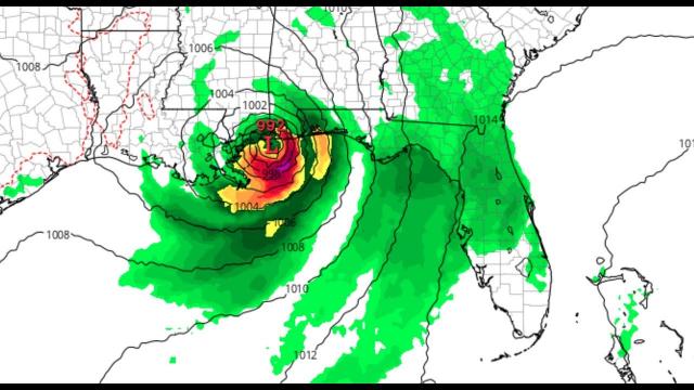
The GFS is now in synch with the KINGEuro and the ICON. Whatever Barry is, the Gulf Coast from Florida to Louisiana (and possibly Texas if Models continue to take it west) we will know more tomorrow night after Mercury goes retrograde. This is slated to start around high noon, friday the 12th and last who knows?
God bless everyone,
T
for kisses, cookies, candy and smokes
T LEWISON
5430 BIRDWOOD RD. #416
HOUSTON TEXAS 77096
HTTPS://WWW.PAYPAL.ME/THORNEWS
video
https://weather.com/storms/hurricane/news/2019-07-05-tropical-disturbance-gulf-of-mexico-southeast-coast
A Tropical Depression or Tropical Storm Might Form in the Gulf of Mexico Next Week. Here's What We Know Now.
An area of low pressure may form along a front in the northern Gulf of Mexico late in the week ahead.
This is an area where July tropical storms have formed in the past.
If a low pressure does form, and enough thunderstorms persist, a tropical depression or storm could form.
Whether or not development occurs, locally heavy rain is possible from the northern Gulf Coast to the Southeast coast.
There is an increasing chance low pressure may develop into a tropical depression or tropical storm late in the week ahead in the northern Gulf of Mexico. Locally heavy rain may soak parts of the Gulf Coast and Southeast regardless of whether the low develops.
Computer forecast models over the past several days have hinted that an upper-level disturbance meteorologists call a mesoscale convective vortex (MCV) will drop through the Deep South this weekend, then over the Gulf of Mexico in the week ahead.
These swirling areas a few thousand feet above the ground are produced by thunderstorm clusters. Because they already have spin, moisture and energy, they can occasionally become tropical systems once over water.
As this occurs, a weak cold front will glide through the South then stall out off the Southeast coast to the northern Gulf of Mexico.
These old frontal boundaries with converging winds often serve as breeding grounds for tropical development early in the hurricane season.
If the upper-level system can maintain itself over land before moving over the northern Gulf, it could help spin up an area of low pressure along the old front. This could start the process of developing a tropical depression over Gulf water that is already warmer than average for early July.
It's also possible a second area of low pressure could briefly form along the old front somewhere off the Southeast coast.
What We Know and Don't Yet Know
The National Hurricane Center outlined a low possibility – a two in ten chance – of tropical development late in the week ahead in the northern and eastern Gulf.
It is still far from certain whether any tropical development over the Gulf of Mexico or off the Southeast coast will occur at all late in the week.
For now, residents along the northern Gulf Coast and Southeast Coast should simply monitor the forecast for late in the week and next weekend, knowing that conditions could change. It's also a good time well ahead of any storm to make any necessary preparations for a tropical storm or hurricane.
What is more certain, however, is an extended period of locally heavy rain is in play over parts of the Gulf Coast and Southeast that is different from the more typical daily afternoon scattered thunderstorms of summer.
There will be patches of locally heavy rain scattered about the Southeast from the Carolinas to the northern Gulf Coast through mid-week.