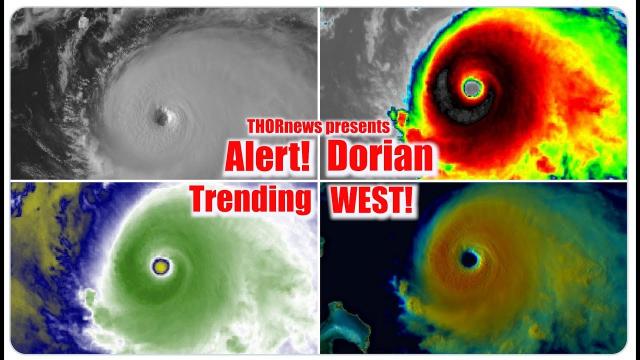
Alert! Category 4 Hurricane Dorian Florida Landfall is latest projection
Description
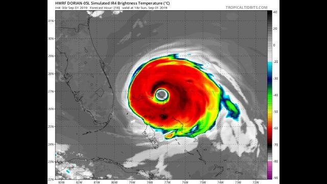
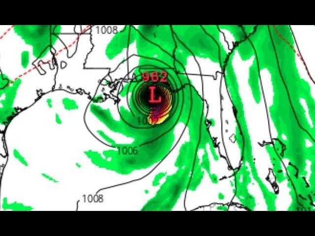
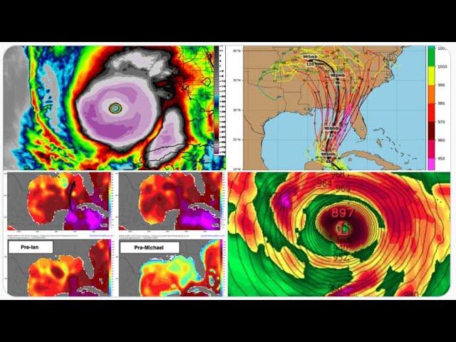
The models have it making landfall from anywhere to a Cat 2 to a Category 4. All agree on a Florida landfall between September 1st and 4th. And what happens AFTER landfall is the REAL surprise and question. Stay tuned!
God bless everyone,
T LEWISON
5430 BIRDWOOD RD. #416
HOUSTON TEXAS 77096
HTTPS://WWW.PAYPAL.ME/THORNEWS
www.venmo.com/TEric-Lewison
$THORnews on CashApp
https://www.patreon.com/thornews
the crankywxguy blog (not me but great info)
http://www.stormhamster.com/entry2/e082919c.htm
dadabuh the florida wave master video
https://www.youtube.com/watch?v=MushFQWelJ8
dorian video
https://weather.com/storms/hurricane/news/2019-08-29-hurricane-dorian-florida-southeast-forecast-projected-path
Hurricane Dorian Expected to Intensify to a Category 4 and Poses a Growing Danger to Southeast U.S., Especially Florida
Hurricane Dorian is now centered in the western Atlantic Ocean.Dorian will then threaten parts of the Bahamas and the southeastern U.S. over Labor Day weekend.The most likely scenario is a track near the Florida Peninsula late in the weekend, but exact details will change.Residents from the northern Gulf Coast to Florida, Georgia and the Carolinas should monitor forecasts closely.
Hurricane Dorian is forecast to intensify into a Category 4 hurricane and pose a major danger to the southeastern U.S., especially Florida, over Labor Day weekend.
Dorian's center is about 220 miles north-northwest of San Juan, Puerto Rico, with maximum sustained winds of 85 mph.
No hurricane watches or warnings in effect at this time, but they will likely be issued for parts of the Bahamas and Florida in the next day or two.
Below is the latest on Dorian's timing and what we know about potential forecast impacts right now.
Dorian's Forecast Timing
Through Friday: Dorian's center is expected to track to the east and north of the Turks and Caicos and the southeastern Bahamas.
Saturday: Dorian will bend toward the west-northwest and potentially begin to impact the northwest Bahamas, particularly by late in the day.
Sunday-Monday: Dorian will slow down as it approaches and begins to impact the Southeast U.S., mostly likely somewhere between Florida and southeast Georgia. That said, areas as far north as the Carolinas should also monitor for potential impacts from Dorian early next week.
Among the myriad track possibilities are a track farther north toward the southeastern Georgia coast and the Carolinas or one slicing across the Florida Peninsula, then emerging into the Gulf of Mexico and potentially threatening parts of the northern Gulf Coast next week.
The uncertainty in Dorian's exact track is mainly related to an area of high pressure off the East Coast. If high pressure remains strong over the Southeast, then Dorian would track straight into Florida. But if the western periphery of the high is significantly eroded by a subtle disturbance moving through the eastern states, then Dorian could turn more northward near or off the coast of Florida.
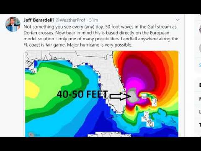
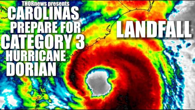
Regardless of its exact track, Dorian is likely to be a dangerous hurricane, potentially a Category 4, when it approaches the U.S. later this weekend.
Furthermore, it is increasingly likely Dorian will both intensify and grow in size as it moves toward the southeastern U.S.
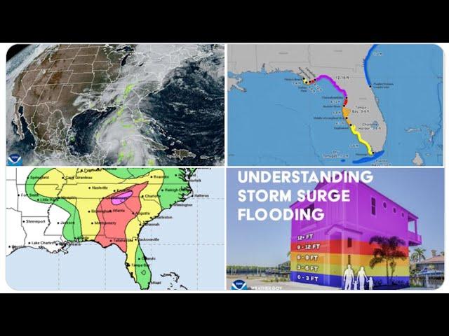
It's too early to know the exact magnitude and location of any impacts from damaging winds, storm surge or flooding rainfall at this time.
All interests in the Bahamas, the northern Gulf Coast, Florida, Georgia and the Carolinas should have their hurricane plans ready and monitor the forecast of Dorian closely.
Destructive winds and life-threatening storm surge flooding will likely impact the east coast of Florida or some other part of the Southeast late this weekend into early next week, but it's too early to nail down where the worst impacts will be.
In addition, the highest high tides of the year, know as "king tides," are expected this weekend in parts of Florida. King tides occur several times a year and when combined with a major weather system, the floodwater inundation can be much more significant.
If you live in an area prone to storm surge, be sure to follow the advice of local officials if evacuations are ordered.