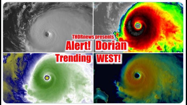
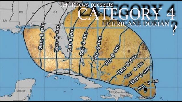
RED ALERT! Carolinas! Prepare for Category 3 Hurricane Dorian Landfall!
Description
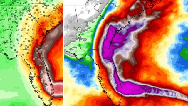
Dorian appears to be inching closer to a North Carolina landfall.
It's not a sure thing yet. but the odds are increasing. It looks like without a miracle or some serious east wobbles, this thing is coming ashore. Stay aware.
God bless everyone,
T LEWISON
5430 BIRDWOOD RD. #416
HOUSTON TEXAS 77096
HTTPS://WWW.PAYPAL.ME/THORNEWS
www.venmo.com/TEric-Lewison
$THORnews on CashApp
https://www.patreon.com/thornews
check out me @newTHOR & @crankywxguy on twitter
and Crankywxguy blog for a total breakdown
http://www.stormhamster.com/entry2/e090319.htm
weather channel vid on dorian
https://weather.com/storms/hurricane/news/2019-09-04-hurricane-dorian-florida-georgia-carolinas-forecast-wednesday
Hurricane Dorian Intensifies to Category 3; Will Pound Coasts of Georgia, the Carolinas and Virginia Through Friday
Outer rainbands are pushing farther into southeastern Georgia and the coasts of the Carolinas while gradually tapering off along the northeastern Florida coast. Along with heavy rain and stronger wind gusts, rotating cells within these bands are capable of spawning short-lived, fast-moving tornadoes.
Wind gusts in those rainbands on Wednesday morning reached 55 mph on Sapelo Island, Georgia, and 49 mph on Isle of Palms, South Carolina. Wednesday afternoon, a wind gust of 52 mph was reported in Jacksonville, Florida. Sustained winds of 45 mph and a gust of 56 mph were measured just south of Charleston, South Carolina, early Wednesday evening.
A 69-mph wind gust was also clocked at New Smyrna Beach, Florida, early Wednesday morning.
Significant beach erosion from Dorian's pounding surf has been reported since Tuesday in Flagler Beach, Vero Beach and Daytona Beach, Florida, and Isle of Palms, South Carolina.
Here is a rundown of the current watches and warnings, according to the National Hurricane Center:
Storm Surge Warning
-Mouth of the St. Marys River at the border between Florida and Georgia to Poquoson, Virginia. This includes the Pamlico and Albemarle sounds and the Neuse and Pamlico rivers in North Carolina, as well as Hampton Roads, Virginia.
-Cities included in the warning are St. Simons Island, Georgia; Tybee Island, Georgia; Charleston, South Carolina; Myrtle Beach, South Carolina; Wilmington, North Carolina; Morehead City, North Carolina; Nags Head, North Carolina; and Hampton Roads, Virginia.
-A storm surge warning means there is a danger of life-threatening inundation, from rising water moving inland from the coastline, within the warning area during the next 36 hours. If you live in an area prone to storm surge, be sure to follow the advice of local officials if evacuations are ordered.
Hurricane Warning
-The entire coasts of South Carolina and North Carolina, including the Albemarle and Pamlico sounds.
-The hurricane warnings in South Carolina include Hilton Head Island, Charleston and Myrtle Beach. Wilmington, Morehead City and Nags Head are included in the warning for North Carolina.
-A hurricane warning means hurricane-force winds (74-plus mph) are either already occurring or expected somewhere within the warning area, generally within 36 hours. Preparations to protect life and property should be rushed to completion.
Hurricane Watch
-Mouth of the St. Marys River at the border between Florida and Georgia to the Savannah River at the border between Georgia and South Carolina.
-A hurricane watch means hurricane-force winds are possible within the watch area. It is generally posted 48 hours before the first tropical-storm-force winds (39-plus mph) are expected.
Tropical Storm Warning
-Mouth of the St. Marys River at the border between Florida and Georgia to the Savannah River at the border between Georgia and South Carolina. A tropical storm warning is also in effect from the North Carolina/Virginia border northward to Chinoteague, Virginia, including the Chesapeake Bay from Smith Point southward.
-This warning also extends to inland locations in eastern Georgia, eastern South Carolina and eastern North Carolina.
-A tropical storm warning means tropical-storm-force winds are expected within 36 hours.
Tropical Storm Watch
-North of Chincoteague, Virginia, to Fenwick Island, Delaware, including the Chesapeake Bay from Smith Point to Drum Point and the Tidal Potomac River south of Cobb Island, Maryland.
-This includes Salisbury and Ocean City, Maryland.
-A tropical storm watch means tropical-storm-force winds are possible within 48 hours.


Comments