Will SNOWFALL from Nor'easter #4 CRUSH New York City with SNOW? aka SHOCK N' Y'ALL!
Description
This is the 4th Nor'Easter to hit the North East Atlantic Coast shores in 2 weeks. This one is carrying a lot of a loft moisture from the storm system that just exited the Coast. Will today's long duration ice rain and snow event bring some eye popping, traffic halting, record snow fall rates and accumulation to New York City's rumored magic bubble?
Or will Winter Hurricane Toby Keith just be a good old Bernie Rayno snow thump of a foot? Or. will it be like comet ISON. dud city, baby.
I had a lot of fun making this video.
May all the parties involved forgive me.
please.
God bless everyone,
T
https://www.paypal.me/THORnews
https://www.patreon.com/thornews
@newTHOR on twitter
https://www.facebook.com/THORnewsthornews
THORNEWS PO BOX 35946
HOUSTON TEXAS
77235-5946
article on the situation
https://weather.com/storms/winter/news/2018-03-19-winter-storm-toby-fourth-march-noreaster-northeast-snow
Winter Storm Toby, the Fourth Nor'easter This Month, Producing Heavy Snow, Strong Winds, That Will Trigger Tree Damage, Power Outages
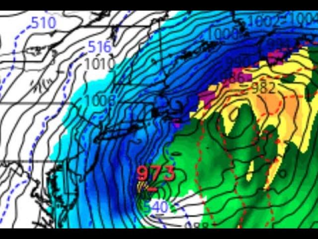
The fourth nor'easter this month, Winter Storm Toby, will hammer the Northeast into Thursday.
Heavy, wet snow, strong wind gusts and coastal flooding will once again occur.
The wet snow and gusty winds will trigger power outages and tree damage in parts of the Northeast.
Snow, heavy in spots, will also persist in the Ohio Valley and Appalachians.
Winter Storm Toby, the fourth nor'easter in less than three weeks, may be one of the heaviest snowstorms this late in the season along parts of the Interstate 95 Northeast corridor, triggering power outages and tree damage through Thursday.
Heavy snow is now falling over a broad swath of the Mid-Atlantic states, persists in stubborn bands in parts of the Ohio Valley, and snow has also spread into parts of New England.
Snow was falling at the rate of 1 to 2 inches per hour from parts of northern New Jersey into Pennsylvania, including at Newark-Liberty Airport and in the Lehigh Valley.
Already, 2 inches of snow was reported in parts of New York City, after an early morning of rain, sleet and snow.
To the south, light snow accumulations have been reported in the Baltimore and Washington D.C. metros. Dulles Airport reported 2.2 inches of snow Wednesday morning. Parts of Frederick County, Maryland picked up 9 to 10 inches of snow through Wednesday morning.
The heaviest snow, so far, has fallen in parts of southern Pennsylvania and the Appalachians. Nearly 14 inches has piled up in Greencastle, near the Maryland border. Over 10 inches of snow has fallen in parts of western Maryland and the high country of West Virginia.
A thin band of freezing rain early Wednesday brought up to 0.2 inch ice accumulation in parts of Delaware and southern New Jersey, downing at least one tree limb in Odessa, Delaware.
Not to be outdone, a persistently heavy snowband parked itself over parts of southern Indiana and northern Kentucky.
The weight of this wet snow has already downed trees in the Louisville metro early Wednesday, where snow was falling at the rate of 1 inch per hour. Storm totals in parts of the metro had already approached or exceeded 10 inches.
Winter storm warnings, where snowfall is expected to be heaviest, extend from eastern Massachusetts to the Smoky Mountains of Tennessee and North Carolina, including the cities of Boston, Providence, Hartford, the entire New York City Tri-State area, Philadelphia, Baltimore and Washington D.C.
Winter storm warnings are also in effect in parts of the Ohio Valley, including the cities of Cincinnati and Louisville.
Winter weather advisories, where snow accumulations will still have some impact, have also been hoisted in the Ohio Valley from parts of Indiana, Kentucky, Tennessee and the piedmont of North Carolina to coastal Maine.
Wednesday
Snow, heavy at times, is expected along the Interstate 95 corridor from near the Washington D.C. metro to partgs of southern New England.
Snow will also linger in the Ohio Valley and the Appalachians as far south as the Smoky Mountains of Tennessee and North Carolina.
Snow will continue Wednesday night from Maine to Maryland, and also in the Appalachians.
Strong winds will continue to build from Delaware and the Jersey Shore to Long Island and New England Wednesday, continuing into Wednesday night from the piedmont of North Carolina to the mid-Atlantic states and coastal New England.
While these winds don't look as strong as this month's earlier nor'easters, they will still lead to some power outages and tree damage when combined with accumulating wet snow.
Coastal flooding and beach erosion, yet again, are possible from the Delaware coast to New England through Wednesday night.
Thursday
Any lingering snow in coastal southeastern New England should end by late afternoon.
While not as strong as Wednesday, some gusty winds are likely to persist in eastern New England, and parts of the Mid-Atlantic states.