Nor'Easter #3 & Nor'Easter #4 & Lots of Rain & Snow for the West Coast USA & CANADA
Description
Nor'Easter #3 in this March Nor'Easter Parade of 2018 is turning out to be Nasty. The West Coast including Washington, Oregon & California will get hit with wave after wave of rain and we've already got our sights set on the next Nor'Easter.
God bless everyone,
T
https://www.paypal.me/THORnews
https://www.patreon.com/thornews
@newTHOR on twitter
https://www.facebook.com/THORnewsthornews
THORNEWS PO BOX 35946
HOUSTON TEXAS
77235-5946
article on the situation
https://www.accuweather.com/en/weather-news/mid-atlantic-snow-to-evolve-into-travel-halting-blizzard-in-new-england-early-this-week/70004372
Travel-halting blizzard eyes New England with heavy snow, ferocious winds
Heavy snow and blizzard conditions may bring travel to a halt in Boston and Portland, Maine, on Tuesday.
Greatest risk for widespread power outages and threat to lives and property to exist in eastern New England.
Follow along with our live storm coverage.
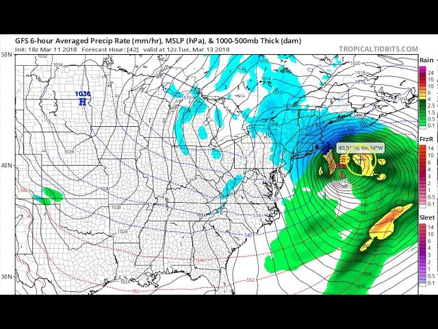
The disruptive snowstorm that targeted parts of the mid-Atlantic on Monday will lash eastern New England with blizzard conditions on Tuesday.
The storm rapidly strengthened from early Monday to early Tuesday and underwent bombogenesis. While the storm is not the strongest of the winter to affect the region, it will still pack a punch and is producing snow all the way to Cape Cod, Massachusetts.
Eastern New England is bracing for the worst of the storm with more than a foot of snowfall, blizzard conditions and strong winds.
Storm to wind down in New York City early Tuesday afternoon
The track of the storm will allowed the Interstate-95 corridor from Philadelphia to New York City to escape the worst of the nor'easter.
Snowfall has been persistent enough from Trenton, New Jersey, to around the New York City area to bring a general 1-3 inches of slush with more on non-paved surfaces.
Much heavier snow is forecast for eastern Long Island, New York where snowfall may top a foot.
New England to face another nor'easter; Blizzard conditions to lash eastern areas
Regardless of the amount of snow that falls for the duration around New York City and its suburbs, the storm is expected to be more disruptive and damaging across New England.
The strengthening nor'easter will drop enough snow to plow, shovel and cause slick travel over New England into Tuesday night. The snow may continue to pile up across northern New England and parts of northern New York state on Wednesday and Thursday as the storm stalls over southeastern Canada.
Snowfall in northern and eastern New England may exceed 2 feet in some locations into the middle of the week. Travel will be extremely difficult as the snow clogs roads.
As is the case with many nor'easters, a span of 25 miles may be the difference between a manageable amount of snow to one that severely hampers travel and daily activities.
Roofs, especially flat ones, that have not been cleared of the excessive snowfall from the last nor'easter may fail during this heavy snow event.
Strong winds are expected to create dangerous blizzard conditions along the eastern coast of New England. Travel can be brought to a halt in Boston and Portland, Maine, on Tuesday. The ripple effect of flight cancellations at these major airports may impact air travelers elsewhere in the nation as crews and aircraft are displaced by the storm.
The combination of the wind and snow can lead to renewed power outages and tree damage, especially where wires and branches have been weakened by the recent nor'easters.
Winds can gust between 45 and 55 mph along the New England coast with gusts to around 70 mph possible on Cape Cod and the nearby islands.
Motorists that venture out during or just prior to the storm's arrival will be at risk for getting stranded. A winter survival kit is a must for those who must travel.
The storm will cause high winds and waves to pound the New England coast into Tuesday night. Residents along the coast can expect moderate to major flooding for two high tide cycles. Tides are expected to average 2-4 feet above normal with this storm.
"As has been the case with the prior nor’easters in the past couple of weeks, small craft should remain in port as the storm approaches," Sosnowski said. "Large ocean-going vessels may want to consider altering their schedule until the risk of heavy seas subsides."
While the impending nor’easter is expected to avoid the central Appalachians and Great Lakes, these areas will not escape cold winds, snow showers and localized squalls early this week.
Cold air with brisk to blustery conditions is forecast to linger into the St. Patrick's Day weekend in the wake of the storm.