Prepare for Nor'Easter #3 & A New West Coast Sky River + Severe Weather in between.
Description
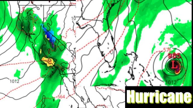
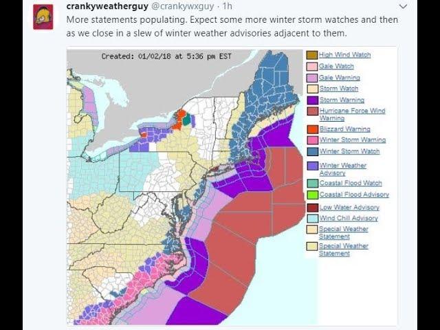
3rd Nor'Easter in 10 days?
Are you ready to face these wild weather challenges together?
We've got activity on all sides in this wave after wave after wave nor'easter parade 2018. Be ready. Have no fear. Stay Cool.
God bless everyone,
T
https://www.paypal.me/THORnews
https://www.patreon.com/thornews
@newTHOR on twitter
https://www.facebook.com/THORnewsthornews
THORNEWS PO BOX 35946
HOUSTON TEXAS
77235-5946
articles on the situation
https://www.accuweather.com/en/weather-news/downpours-locally-strong-storms-to-return-to-southern-us-this-weekend/70004359
https://www.accuweather.com/en/weather-news/downpours-locally-strong-storms-to-return-to-southern-us-this-weekend/70004359
Downpours, locally strong storms to return to southern US this weekend
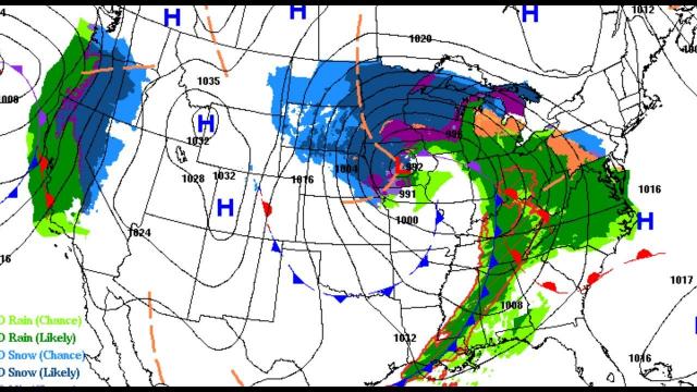
Nor'easter poised to bring snow, rain and wind to mid-Atlantic by early week
The same storm has the potential to drop snow in the southern and central Appalachians and evolve into another disruptive nor'easter for the mid-Atlantic and New England.
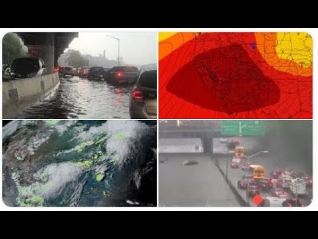
An area of rain and thunderstorms is likely to develop across the lower Mississippi Valley on Saturday and progress eastward across the Deep South through the balance of the weekend.
In order for the storm to turn northward and produce a broad swath of heavy snow from Washington, D.C., to Boston, the jet stream will have to dramatically change position to allow the storm to back closer to the coast.
“The most likely area for heavy rain will be from Arkansas to northern Louisiana, Mississippi, Alabama and perhaps into Tennessee,” AccuWeather Meteorologist Ryan Adamson said.
Georgia and the Carolinas may get a thorough soaking during the second half of the weekend.
The downpours will heighten the risk of hydroplaning and lower visibility along interstates 10, 20, 22, 40, 55, 59, 65, 75, 85 and 95. Airline passengers at the major hubs, including Atlanta and Charlotte, North Carolina, are likely to experience lengthier travel times due to flight delays.
“There is also a threat for locally severe storms, but this will depend on if all of the right ingredients come together,” Adamson said.
At this time, the best chance of a heavy accumulation of snow, clogged roads and power outages from clinging snow is in the mountains from southern West Virginia and west-central Virginia to western North Carolina eastern Tennessee and eastern Kentucky.
“The area at greatest risk for severe weather to occur will be from southern Arkansas and northern Louisiana down through southern Mississippi, Alabama and the Florida Panhandle, and the most likely time frame would be late Saturday into Sunday,” he added.
Should a few severe storms ignite, the primary threats would be large hail and winds strong enough to knock down trees and power lines. However, a few tornadoes cannot be ruled out.
Flooding is possible but will not be widespread, according to AccuWeather Lead Long-Range Meteorologist Paul Pastelok.
The ground has had an opportunity to dry out a bit following the deluge during the end of February that triggered extensive flash, urban and river flooding across the Mississippi and Ohio valleys. Thus, any incidents of urban or small stream flooding are likely to be localized with this event.
Snow is likely to turn to rain in the mountains of North Carolina and Tennessee on Sunday.
Farther to the northeast, including the Washington, D.C., area, a combination of rain and snow is likely in eastern Virginia, eastern Maryland, Delaware and southern New Jersey.
The winds will push water toward the coast and result in flooding at times of high tide from northeastern North Carolina to southern New Jersey. The worst conditions are likely in southeastern Virginia, northeastern North Carolina, the eastern part of Maryland and southeastern Delaware, where tides may run 1-3 feet above normal.
On Thursday morning, the Bonnet Carre Spillway in St. Charles Parish, Louisiana, was opened for only the 12th time in its 87-year history in order to relieve strain on levees and prevent possible flooding in New Orleans, according to NOLA.com.
Cities such as Norfolk, Virginia, and Ocean City, Maryland, should be prepared for flooding problems related to storm surge and heavy rainfall.
Wind gusts in this same zone may be strong enough to knock down trees and cause power outages.
Cities such as Norfolk, Virginia, and Ocean City, Maryland, should be prepared for flooding problems related to storm surge and heavy rainfall. Wind gusts in this same zone may be strong enough to knock down trees and cause power outages.


Comments