Tropical Storm DORIAN & The MULTIPLE September Hurricane Dangers.
Description
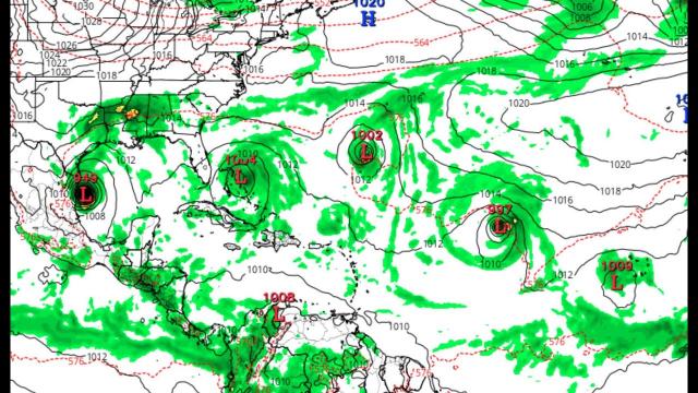
We're already looking at multiple threats to multiple areas.
Stay Aware. Be Prepared. Have a plan.
God bless everyone,
T LEWISON
5430 BIRDWOOD RD. #416
HOUSTON TEXAS 77096
HTTPS://WWW.PAYPAL.ME/THORNEWS
www.venmo.com/TEric-Lewison
$THORnews on CashApp
https://www.patreon.com/thornews
the crankywxguy blog
http://www.stormhamster.com/entry2/e082519b.htm
https://weather.com/storms/hurricane/news/2019-08-24-tropical-storm-dorian-hurricane-caribbean
Tropical Storm Dorian Forecast to Reach the Caribbean on Tuesday, Potentially as a Hurricane
Tropical Storm Dorian is churning westward toward the Lesser Antilles and is likely to bring rain and strong winds to southern parts of those islands in the first half of the week ahead.
Dorian is located several hundred miles east-southeast of Barbados, moving steadily west at 10 to 15 mph.
A tropical storm warning has been issued for Barbados. That means tropical storm conditions (39-73 mph winds) are expected there within the next 36 hours.
In addition, tropical storm watches are now in effect for St. Lucia along with St. Vincent and the Grenadines. Tropical storm conditions are possible in those areas within the next 48 hours.
On its predicted path, Dorian will approach the Windward Islands in the southern Lesser Antilles by late Monday or early Tuesday.
Dorian continues to be a rather small tropical storm, and that makes its intensity forecast uncertain.
Sea surface temperatures are warm ahead of the system, and upper-level winds are expected to relax. These factors favor intensification.
However, the mid-level atmosphere is moderately dry, and that may keep a brake on any rapid strengthening. If the storm can develop an inner core of moisture and keep it walled off from the dry air, more sustained intensification would be possible.
A NOAA Hurricane Hunter plane is en route to investigate the environment (i.e. wind shear, atmospheric moisture) around Dorian to get a better idea of the conditions that Dorian is facing, which should improve tropical models.
The most apparent threat that Dorian will bring is heavy rainfall, but at least a narrow stretch of the Windward Islands could get damaging winds near where Dorian passes through.
Dorian could approach the islands as a strong tropical storm or a low-end hurricane, but wind impacts will vary greatly from one island to the next due to the small size of this system.
Tropical storm-force winds may approach Barbados by late Monday night and the rest of the Windward Islands by early Tuesday.
Flooding rainfall is possible near where Dorian tracks through the Windward Islands. Rainfall totals of 2 to 4 inches (locally 6 inches) are possible in portions of the Lesser Antilles.
It’s too soon to know what impacts, if any, Dorian might bring later this week to Puerto Rico and Hispaniola.
The forecast further out in time is even more uncertain so it's too soon to know if Dorian will affect the mainland U.S. coastline.
Prime Time and a Prime Location
Dorian is located in the heart of the deep Atlantic tropics, also known as the Main Development Region. Tropical storms and hurricanes are most common in this region from late July into September as tropical waves move off Africa and into the Atlantic.
Such tropical waves emerging off the west coast of Africa are often referred to as Cabo Verde systems because many of them pass near the Cabo Verde Islands.