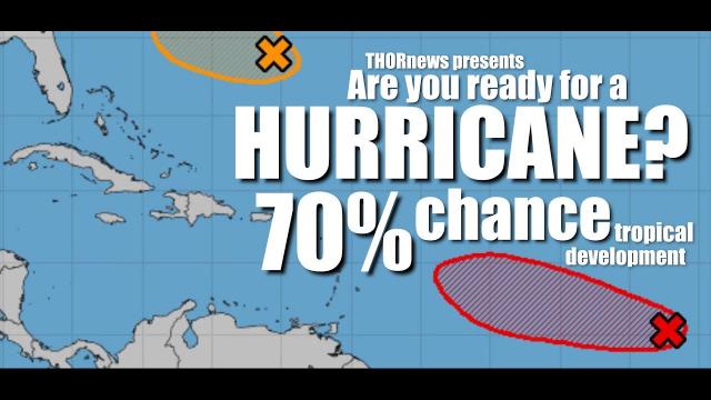
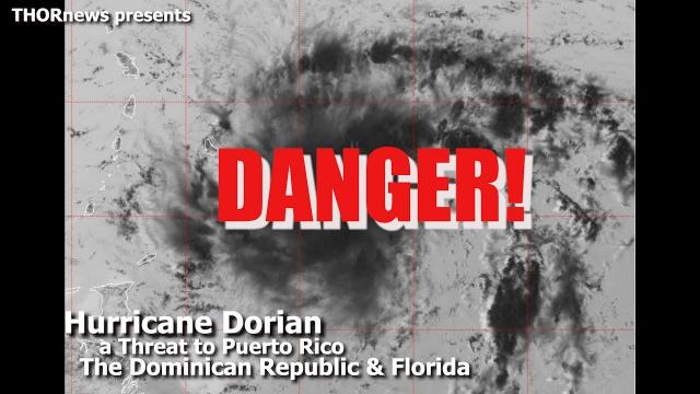
TD2 is headed towards Puerto Rico & might become a Hurricane.
Description
Tropical Depression 2 is soon to be Tropical Storm Beryl is now officially in play. Meteorologists are convinced that wind shear & Sahara Dust will tear it to pieces but me & the models disagree that this thing is "harmless" to Puerto Rico. It's got a decent rain field regardless.
God bless everyone,
T
T
https://www.paypal.me/THORnews
Tshirts
https://hitthebuttonbaby.com/
THORNEWS
PO BOX 35946
HOUSTON TEXAS
77235-5946
the excellent cranywxguy blog
http://www.stormhamster.com/entry/e070518.htm
The Surf Master
http://www.dabuh.com
articles
https://weather.com/storms/hurricane/news/2018-07-04-tropical-systems-watching-atlantic-early-july
Two Areas in the Atlantic Are Being Watched For Tropical Development
The National Hurricane Center is watching two areas in the Atlantic for tropical development.
One system near Bermuda will curve away from the U.S. and out to sea.
Invest 95L in the Atlantic will likely encounter hostile upper-level winds by this weekend, causing it to become less organized.
Two low-pressure systems in the Atlantic Ocean are being monitored for tropical development late this week, but neither of them is likely to pose a significant threat to land in the days ahead.
You can see the two areas of disturbed weather that the National Hurricane Center (NHC) is currently watching in the tropical outlook graphic below. One of them is located near Bermuda and the other is in the tropical Atlantic between Africa and the Caribbean Sea.
Here's an in-depth look at these two systems and why they are not a major concern at this time.
Tropical System Near Bermuda
The system closest to the U.S. and currently centered south of Bermuda has a medium chance of developing into a tropical depression by the end of this week, according to the NHC.
Regardless if it develops, this area of low pressure will track west-northwest, north and then northeast away from the U.S. coastline into the weekend. A cold front moving off the East Coast by Friday night will be responsible for deflecting this system out to sea.
Therefore, even if a tropical depression did develop there would be no direct threat to the U.S. since it would remain several hundred miles offshore. That said, it could increase the chance of rip currents in eastern North Carolina Friday-Saturday, the National Weather Service says.
Tropical System in the Atlantic
Showers and thunderstorms are flaring up in association with an area of low pressure moving westward between Africa and the Lesser Antilles. The NHC has dubbed this system Invest 95L in order to collect specialized data sets and computer model guidance on the area of interest.
Invest 95L has a low chance of forming into a tropical depression the NHC says, but they added that some additional development could occur in the next few days as it continues to churn westward.
By this weekend, this system will approach the Lesser Antilles in the eastern Caribbean. The good news is that upper-level winds will become more hostile for development by that time, likely preventing further organization.
That said, the area of disturbed weather could enhance moisture in the Lesser Antilles Sunday into Monday, leading to an uptick in shower and thunderstorm activity.
We will continue to monitor these two areas of interest in the Atlantic over the next few days, but for now, there is no major threat to be concerned about.
https://www.accuweather.com/en/weather-news/waters-off-us-east-coast-may-give-birth-to-next-tropical-storm-west-of-bermuda/70005394
Waters off US East Coast may give birth to next tropical storm west of Bermuda
"As this disturbance drifts westward, it may enter a zone of low wind shear and begin to develop some spin late this week," Vido said.
Wind shear is the change in wind direction and increase in speed at different layers of the atmosphere. A tropical storm is more likely to form in a low wind shear zone, rather than a high wind shear zone.
Steering winds are likely to increase, pick up the feature and pull it northward early this weekend. Later this weekend into next week, these steering winds will guild the feature northeastward.
"The only way this feature would impact the U.S. is if it became well-organized, such as a strong tropical storm," according to AccuWeather Senior Meteorologist Dan Pydynowski.
A strong tropical storm might produce enough winds to generate rough seas and surf along the mid-Atlantic and New England coasts, as well as Bermuda, while a poorly organized feature would not.
southeastern Newfoundland
Elsewhere over the Atlantic basin, conditions remain rather hostile for tropical development.
"There is another area of disturbed weather over the south-central Atlantic
"If that feature could somehow organize into a tropical depression or storm, it would likely encounter much greater wind shear farther west near the Leeward and Windward islands as well s over the Caribbean Sea,"
Beryl and Chris.