Super Wild Weather! Major California Storms & 222 Rivers Flooding in the South & so much more
Description
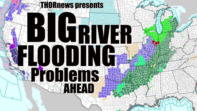
We've got an atmospheric river hitting California hard right now. That storm will continue until Thursday. On Saturday the next storm will arrive. There are 222 rivers flooding, most in the South with the next wave of storms fast approaching and records are falling like crazy.
God bless everyone,
T
https://www.paypal.me/THORnews
@newTHOR on twitter
https://www.facebook.com/thornewsgo
Tshirts
https://hitthebuttonbaby.com/
the crankywxguy blog
http://www.stormhamster.com/entry/e022619.htm
mike's weather page
http://www.spaghettimodels.com/
models
https://www.tropicaltidbits.com/analysis/models/
a look at the Sun
https://sdo.gsfc.nasa.gov/data/
https://weather.com/forecast/regional/news/2019-02-26-california-sierra-feet-of-snow-february-records
Atmospheric River to Pummel California's Sierra With Up to 10 Feet of Snow, Topping February Records
Another atmospheric river event is pounding California with feet of snow in the Sierra.
February snow records are falling in the Sierra.
The combination of this, plus high winds, is shutting down travel in the Sierra.
Heavy rain is also triggering flooding, mudslides and rockslides in Northern California.
High winds are also pounding the Sierra crest and areas downwind, including Reno, Nevada.
Another atmospheric river event is pummeling California with feet of snow in the Sierra Nevada Mountains, shattering February snow records at some ski resorts while also triggering flooding, rockslides and mudslides in lower elevations.
Happening Now
Heavy snow continues to pound the Sierra, generally above 4,500 feet. The combination of heavy snow and high winds prompted Interstate 80 to shut down overnight Monday night into Tuesday.
Several other routes into the Sierra were shut down Tuesday as well, according to Caltrans.
Many Sierra ski locations reported at least a foot of snow in 24 hours ending Tuesday morning. Caltrans reported 40 inches of snow had fallen in 24 hours at Donner Pass.
Despite all the snow, it was too windy to ski at some Sierra resorts. Lifts were on hold at Mammoth Mountain, and some lifts were closed Monday at Heavenly.
Strong winds have also been blasting parts of Northern California and Nevada. Winds gusted between 50 and 60 mph in Reno, Nevada, on Tuesday.
Rain is soaking lower elevations of Northern California, mainly north of Interstate 80, and that has triggered flooding and some landslides.
A number of mudslides shut down State Highway 49 in multiple locations. Just over 5 inches of rain was reported in Quincy, California, about 35 miles east-northeast of the fire-scarred town of Paradise.
Flooding was also reported in parts of Marin County, California, and the Napa Valley. All access roads into Point Reyes National Seashore, north of San Francisco, were flooded Tuesday morning.
Forecast
This latest pounding is being triggered by a plume of moisture known as an atmospheric river being piped into the state by an area of low pressure moving in from the Pacific Ocean
Atmospheric river events are now classified somewhat analogous to hurricanes. This atmospheric river is being categorized as a Category 3 event, meaning it's not only beneficial for the state's water supply, but also hazardous in terms of threats from floods and landslides.
The heaviest Sierra snow and low-elevation rain should fall through Wednesday morning. However, Sierra snow, and at least some low-elevation showers, should linger into Wednesday night and Thursday.
Those final snow totals are likely to be impressive, once again measured in feet.
Monday afternoon, the National Weather Service in Sacramento said parts of the northern Sierra could see up to 10 feet of snow into Wednesday.
In general, anywhere from 36 to 80 inches of storm-total snowfall was expected in the Sierra through Wednesday above 4,500 feet in elevation, NWS-Sacramento said.
This combination of prolific snow and high winds may lead to tree damage and power outages. Combined with the impressive snowpack already on the ground, it could also lead to impassable roads, side streets and even driveways. Snow slides into homes or roof collapses are possible in a few areas.
Mammoth Mountain has already clobbered its previous record-snowiest February, picking up 198 inches of snow so far this month.
Squaw Valley is likely to set its snowiest month on record, already measuring over 21 feet of snow this month before this storm kicked into gear.
Tuesday morning, a snow depth of 226.9 inches was estimated by the National Resources Conservation Service SNOTEL network at a sensor about 20 miles southwest of Truckee, California. Another sensor at Nevada's Mt. Rose Ski Area estimated a whopping 320 inches of snow cover at an elevation of 8,850 feet.
Most importantly, the Sierra is an important source of water for California when winter's snowpack melts in the dry season from late spring through early fall.