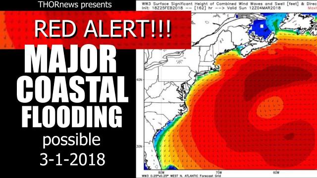
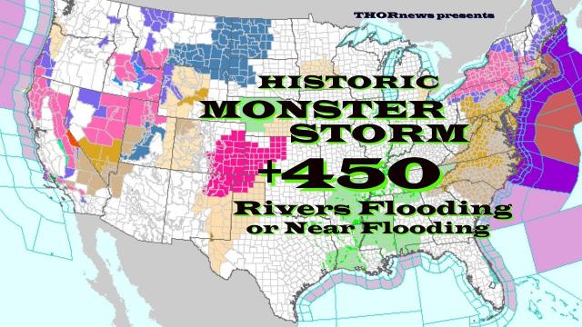
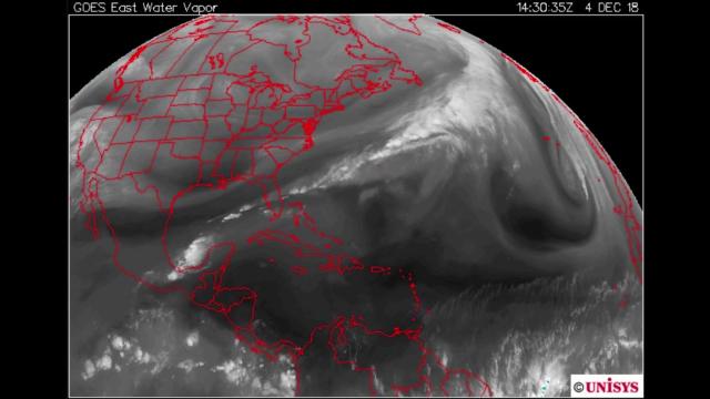
367 rivers flooding, East Coast Earthquakes, MAJOR Storms USA & Europe
Description
Planetary Orbital Angular Momentum is the answer to your question.
God bless everyone,
T
https://www.paypal.me/THORnews
@newTHOR on twitter
https://www.facebook.com/thornewsgo
Tshirts
https://hitthebuttonbaby.com/
the crankywxguy blog
http://www.stormhamster.com/entry2/e031119.htm
mike's weather page
http://www.spaghettimodels.com/
models
https://www.tropicaltidbits.com/analysis/models/
a look at the Sun
https://sdo.gsfc.nasa.gov/data/
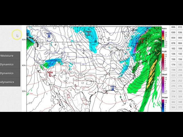
https://weather.com/storms/winter/news/2019-03-11-winter-storm-ulmer-forecast-west-plains-blizzard-conditions
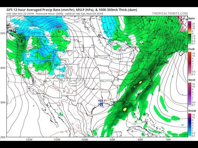
Winter Storm Ulmer Intensifying Into a Major Plains Blizzard With Heavy Snow and High Winds
Ulmer is intensifying in the Plains where it will produce heavy snow and high winds into Thursday.
Blizzard warnings have been issued from northeast Colorado to North Dakota and northwest Minnesota.
Travel conditions will be nearly impossible due to the combination of heavy snow and high winds.
The Denver metro area will be significantly impacted by snow and wind on Wednesday.
Widespread high winds will also affect locations not expected to see snow.
Ulmer has already set a preliminary low-pressure record in Pueblo, Colorado.
Much of the snow from Ulmer is in the Rockies as of early Wednesday morning.
Snow has also moved into parts of the High Plains, including Cheyenne, Wyoming. Deteriorating weather with increasing snow and wind, including blizzard conditions, will develop in other parts of the central High Plains late morning into the afternoon. That includes a swath from northeast Colorado, including Denver, to western South Dakota.
Blizzard warnings have been posted for portions of the northern and central High Plains, from northeastern Colorado into eastern Wyoming, southeastern Montana, western Nebraska, western and central South Dakota, central and eastern North Dakota and northwest Minnesota. This includes portions of the Denver metro area, as well as Cheyenne, Wyoming; Scottsbluff, Nebraska; Rapid City, South Dakota; Bismarck, North Dakota and Fargo, North Dakota.
Winter storm warnings, winter storm watches and winter weather advisories have been issued for other parts of the Plains and West.
Wednesday
Winter Storm Ulmer will reach its peak intensity in the Plains through Wednesday night as the low-pressure system strengthens. The atmospheric pressure in the storm could approach some of the lowest readings on record in Kansas.
Pueblo, Colorado, already set its preliminary, unofficial all-time record-low pressure early Wednesday morning, according to the National Weather Service. Colorado state climatologist Russ Schumacher tweeted it was the lowest pressure on record there since at least 1950.
Snow and strong winds will impact the northern and central Plains, as well as the Rockies. This will include parts of the Interstate 25 corridor in Colorado and Wyoming, including Denver and Cheyenne, Wyoming. Denver will start out the day with rain before transitioning to snow and increasing winds.
Blizzard conditions are likely where the snow and strongest winds overlap in the northern and central High Plains, with winds gusting 50 to 70 mph contributing to widespread blowing and drifting snow.
Interstate closures are possible, including Interstate 70 in Colorado, Interstate 80 in western Nebraska and Wyoming and Interstate 90 in western and central South Dakota.
Significant freezing rain accumulations are possible in a small area across central and northeast South Dakota. The icing may cause tree damage and power outages.
Snow or rain changing to snow and blizzard conditions will expand as far north and eastward as eastern North Dakota and northwestern Minnesota late in the day and overnight.
Areas that don't see snow from this storm in the Southwest and Plains will still see high winds. Wind gusts of 40 to 65 mph are likely in those regions on Wednesday.
The winds could cause localized power outages and tree damage and will also be a hazard for high-profile vehicles.
Ulmer will continue to impact the northern Plains with blizzard conditions but will begin to wind down later in the day.
Snow or rain changing to snow will also move through the upper Mississippi Valley into Thursday night.
Strong winds will grip a broad swath of the northern and central Plains and Midwest.
Blowing snow is likely into Thursday evening in the northern Plains as the winds whip up lingering falling snow and snow that is on the ground. Travel should be avoided in this region.
Significant snow will spread across a swath from southeastern Wyoming and northeastern Colorado to western Nebraska, South Dakota, eastern North Dakota and northwestern Minnesota.
The heaviest totals of 1 to 2 feet will bury parts of southeastern Wyoming, western Nebraska and southwestern and central South Dakota. A broader area from northeastern Colorado to eastern North Dakota could see 6 to 12 inches of snow.


Comments