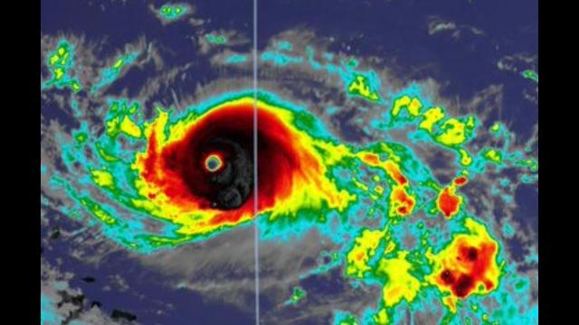
Red Alert! sustained 80 MPH WINDS & rapid Intensification continues as Hurricane Hannah slows!
Description
This Hurricane continues to over perform & could strengthen for several more hours.
God bless everyone,
T LEWISON
5430 BIRDWOOD RD. #416
HOUSTON TEXAS 77096
https://www.paypal.me/THORnews
https://venmo.com/TEric-Lewison
$THORnews on CashApp
https://www.patreon.com/thornews
TWC notes
https://weather.com/storms/hurricane/news/2020-07-24-tropical-storm-hanna-forecast
Tropical Storm Hanna Heads for Texas Gulf Coast; Inland Flooding a Danger Into Northeast Mexico
Tropical Storm Hanna is headed toward a Texas landfall Saturday.
The biggest danger is flooding rainfall.
Locally heavy rain will spread across South Texas into northeast Mexico.
That locally heavy rain will linger well after landfall.
Tropical storm-force winds are expected along and inland of the Texas coast.
Rough surf and minor coastal flooding are expected along the northern and western Gulf Coast.
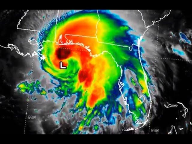
Tropical Storm Hanna formed in the Gulf of Mexico Thursday night and is headed toward a Texas landfall Saturday, with the potential for dangerous rainfall flash flooding extending well inland into northeast Mexico.
Hanna continues to slowly strengthen but is expected to be known for its flood potential.
Thursday night, Hurricane Hunter reconnaissance mission found winds ticked up just enough to upgrade Tropical Depression Eight to Tropical Storm Hanna, the record earliest eighth named storm, beating Tropical Storm Harvey's record, set in 2005, according to Phil Klotzbach, tropical scientist at Colorado State University. Hanna also formed before the previous record for earliest seventh storm, beating the record set by Gert on July 24, 2005.
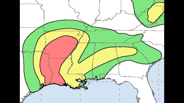
The map below shows the latest tropical storm watches and/or warnings issued. A watch means tropical storm conditions are possible within 48 hours. A warning means those conditions are expected in the next 36 hours.
Tropical storm watches north of San Luis Pass, Texas have been discontinued.
Tropical Storm Hanna is tracking west-northwestward across the Gulf of Mexico toward Texas. Satellite imagery shows this system is producing increasingly concentrated thunderstorms, especially on its southern side. Slow additional strengthening is possible before it reaches the coast Saturday.
Forecast Impacts
Heavy Rain Threat
This will be the primary concern with Hanna.
Some bands of showers and thunderstorms from Hanna will sweep into the Texas, Louisiana and Mississippi coasts Friday. Heavier rain may arrive along parts of the Texas coast overnight Friday night into Saturday morning and continue Saturday as the center makes landfall.
But as with most all tropical cyclones, this won't be just a coastal event.
Locally heavy rain will spread well inland in South Texas into parts of northeast Mexico. This locally heavy rain could persist into Sunday, perhaps Monday, particularly in northeast Mexico.
Flash flood watches have been issued for all of South Texas.
Rainfall totals of over 5 inches are possible in these areas, with locally higher amounts where bands of rain stall for a period of a few hours. This could lead to dangerous flash flooding and some river flooding, particularly in the mountainous terrain of Mexico's Coahuila, Nuevo Leon and northern Tamaulipas states.
Winds, Coastal Flooding and Surge
Tropical-storm-force winds could develop as soon as tonight or Saturday morning and are most likely along or near the Texas Coastal Bend. These winds are capable of some tree damage and sporadic power outages.
Persistent winds blowing onshore to the east of Hanna may produce areas of high surf, rip currents and possibly some minor coastal flooding at high tide, particularly along the northern Gulf Coast.
Coastal flooding closed the bridge along Cedar Lake Road in Biloxi, Mississippi, Thursday afternoon.
Some minor storm surge is expected from the Mexican border north to High Island, Texas, including Corpus Christi Bay, Matagorda Bay, and Galveston Bay. Water levels may climb as high as 3 feet above normally dry ground in this area during high tide.
Keep this in mind if you're spending time on the beaches.