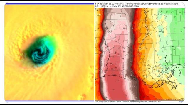
Hurricane Sally is going to be a slow rainmaking monster! 100 MPH sustained winds & will Strengthen!
Description
There are still a lot of questions about timing & intensity of landfall.
God bless everyone,
T LEWISON
J5430 BIRDWOOD RD. #416
HOUSTON TEXAS 77096
https://www.paypal.me/THORnews
https://venmo.com/TEric-Lewison
$THORnews on CashApp
https://www.patreon.com/thornews
weather channel video
https://weather.com/storms/hurricane/news/2020-09-12-tropical-depression-storm-sally-gulf-of-mexico
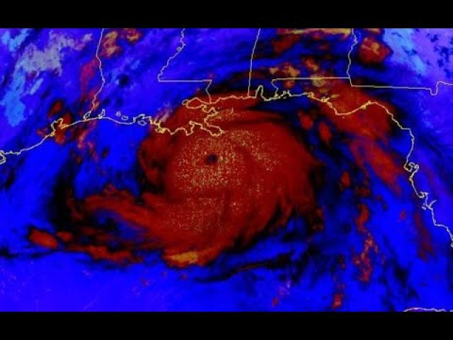
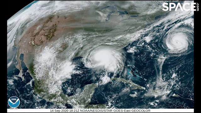
Tropical Storm Sally has reached the southeastern Gulf of Mexico.
The system will traverse the eastern Gulf of Mexico this weekend.
Heavy rain is the big threat from this system from Florida to Louisiana.
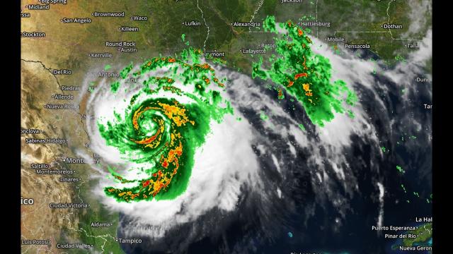
Sally is expected to become a hurricane before landfall.
Sally is the earliest "S" storm on record.
Tropical Storm Sally is moving through the southeastern Gulf of Mexico and will bring heavy rain and gusty winds to Florida and the Gulf Coast through the weekend and into next week, potentially as a hurricane.
A tropical storm watch has also been issued for the Florida panhandle from the Ochlockonee River to the Okaloosa/Walton County Line, including Apalachicola and Panama City. Tropical-storm-force winds are possible there by Sunday night.
A hurricane watch is possible later this weekend due to the expectation that Sally will become a hurricane before landfall.
It has been producing scattered showers and thunderstorms over southern Florida with bands of rain expected through the day.
Lower Matacumbe Key in the Middle Florida Keys has received 8-12 inches of rain since early Saturday morning.
These bands of rain are bringing gusty conditions to South Florida. Wind gusts of 40-55 mph were recorded from Boca Raton to Miami Beach
Saturday morning.
Slow organization is likely today as Sally moves away from southern Florida, but bands of rain will continue to swirl in across the state through the weekend.
A flood watch is in effect for portions of Florida, including Miami, Tampa and Apalachicola, where the system is expected to bring heavy rain and could cause flooding through the weekend.
Rip currents are also likely along both the West and East coast of Florida into Saturday.
A few tornadoes or waterspouts are also possible this afternoon and evening in the Florida Keys, in the Everglades, and Southwest Florida.
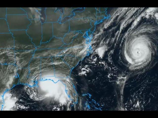
Gulf Coast Hurricane Threat
From there, Tropical Storm Sally is expected to move northwestward toward the northern Gulf Coast, likely as a tropical storm or low-end hurricane.
Sally is the earliest "S" storm to form during a season on record, beating 2005's Stan by 3 weeks.
The system will arrive on the northern Gulf Coast in the first half of next week as a high-end tropical storm or low-end hurricane, but exactly when and where that occurs is uncertain.
If Sally rides the right or northern side of the Hurricane Center's cone of uncertainty, it could arrive in western Florida as soon as Monday morning. If it instead rides the left or southern side of the cone of uncertainty, it could arrive in southwestern Louisiana Wednesday.
In either case, this system is expected to slowly inch toward the coast beginning Sunday and will spread rainfall, high surf and gusty winds to the shore well before landfall.
Some storm surge is also possible in from Mississippi to far western Florida.
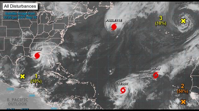
Active Gulf of Mexico Already
A second disturbance, noted as #2 in the graphic below, is producing limited thunderstorms south of the northern Gulf Coast.
It has a low chance of development but will bring rain and gusty winds to the northern and western Gulf of Mexico through the weekend and to South Texas and northern Mexico by early next week.
These systems could bring rainfall and possibly gusty winds to the area of western Louisiana ravaged by Hurricane Laura a few weeks ago.
Forecast Rainfall
Most of Florida will see more than an inch of rainfall, but parts of South Florida could see totals higher than 6 inches.
The relatively slow motion of whatever Sally is when it gets to the northern Gulf of Mexico could lead to high rainfall totals.
Sally could locally drop up to 8 inches of rain along the immediate Gulf Coast near and east of the point of landfall.
Much of Florida, southern Alabama, southern Mississippi and southern Lousiana should expect 1-3 inches of rainfall through Wednesday. The northwestern Bahamas can expect 1-4 inches of rainfall through Saturday.
Southwestern Louisiana, which was hit hard by Hurricane Laura, may get up to an inch of rainfall depending on the track of this system.
Parts of South Texas and northern Mexico may receive up to 2 inches of rain.
Hurricane Season's Second Half
With the peak of hurricane season passing on Thursday, activity will gradually decline through the end of the season in November.
According to the latest forecasts, numerous tropical storms and hurricanes are still expected over the next few months.