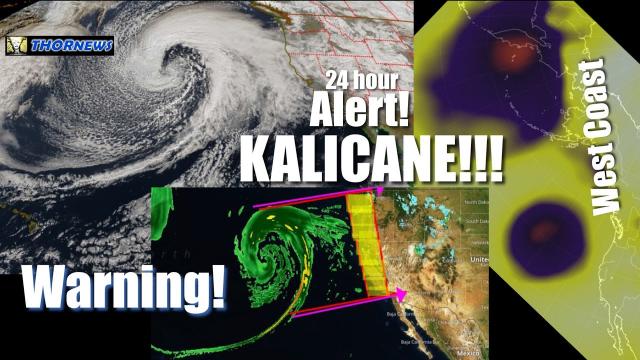
Red Alert! Massive WIND & rain Storm for Texas & East Coast Earthquakes
Description
This strange wind event is 800 miles high and 400 miles wide stretching from New Mexico to Oklahoma to Kansas to Arkansas
& the rain coming out of the pacific is heavy. Plus, we look at the planetary orbital angular momentum theory that will probably bring more Earthquakes to Tennessee and the East Coast. and more challenges.
God bless everyone,
T
https://www.paypal.me/THORnews
@newTHOR on twitter
https://www.facebook.com/thornewsgo
Tshirts
https://hitthebuttonbaby.com/
the crankywxguy blog
http://www.stormhamster.com/entry/e121218.htm
mike's weather page
http://www.spaghettimodels.com/
models
https://www.tropicaltidbits.com/analysis/models/
a look at the Sun
https://sdo.gsfc.nasa.gov/data/
article
https://weather.com/forecast/regional/news/2018-12-12-southeast-flood-threat-after-winter-storm-diego
Heavy Rain, Melting Snow Brings Another Flood Threat to Carolinas and Virginia, Adding to One of Wettest Years on Record
Another round of heavy rain will soak the Southeast Friday and Friday night.
Flash flooding may happen quickly due to saturated ground from North Florida to Virginia.
Lingering snowpack from Winter Storm Diego will melt, adding more water to rivers and streams.
This will prolong river flooding into next week in some areas.
Another round of heavy rain, combined with melting snow, might trigger flash flooding and additional river flooding Friday in parts of the Southeast, adding another chapter to one of the wettest years on record for some.
Last weekend, Winter Storm Diego dumped over a foot of snow in the southern Appalachians of North Carolina and parts of southern Virginia. Despite days with highs reaching the upper 30s or 40s this week, the snow hasn't entirely melted.
Areas that didn't pick up snow were soaked by at least 2 inches of rain from East Texas to the coastal Carolinas, prompting high-water rescues in Houston and leaving some roads in East Texas impassable.
Over the first weekend of December, up to 11 inches of rain triggered major flooding in parts of North Florida and South Georgia. Flooding reached the doors of homes in Waycross, Georgia.
A number of rivers remain above flood stage from Texas to North Florida to North Carolina. Soil moisture remains well above average for mid-December from Texas to the mid-Atlantic, according to NOAA's Climate Prediction Center.
The end result: most of the South and Southeast can't absorb additional heavy rain.
Many areas will have some time to dry out and some rivers will begin to lower by Friday, but it may not be in time in all rivers.
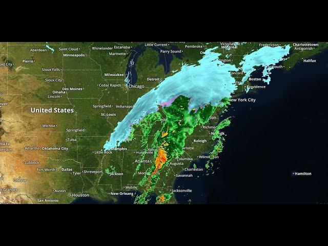
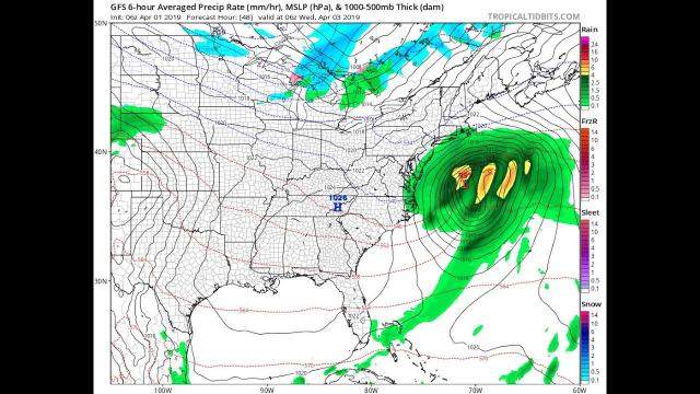
A sharp, southward plunge of the jet stream will pivot through the South Thursday into Friday, tapping a plume of deep moisture from the eastern Pacific Ocean and the Caribbean Sea.
Unlike Winter Storm Diego, this system will lack arctic air on its northern flank, and thus, rain will fall in most areas of the Southeast, even some higher elevations.
Forecast Timing
By early Thursday, showers and thunderstorms will begin to percolate across southern and eastern Texas and up into the mid-South. A few thunderstorms may affect early-morning commuters in the Houston metro area before clearing out by mid-morning.
Thursday, rain and thunderstorms will spread from the Ark-La-Tex region to the lower and mid-Mississippi Valley.
A few rain showers will also begin to curl around the low pressure system in northern Texas and eastern Oklahoma. A few snow showers are also possible in western north Texas and the Texas panhandle.
Thursday night, that general area of rain will slide eastward through the Deep South, from the northern Gulf Coast to the Tennessee Valley and Carolinas.
A few severe thunderstorms are possible from East Texas to the Florida Panhandle Thursday and Thursday night.
Friday, a band of heavy rain with embedded thunderstorms will slide eastward from North Florida to Virginia, with mainly lighter rain stretching westward from the Ohio Valley to the Ozarks.
Friday night, more steady soaking rain might spread up the Interstate 95 corridor of the mid-Atlantic and Northeast as rain continues southward near the coast to the Florida Peninsula, as well as that same westward arc around the upper-level low through the Ohio and Tennessee valleys.Much of the South and mid-Atlantic have a good chance to pick up at least 1 inch of rain through Saturday afternoon.
The best chance for heavier rain is in two corridors:
- From northern Florida through the eastern Carolinas
- Parts of Arkansas, eastern Oklahoma, northeastern Texas and northern Louisiana
This heavier rainfall is likely to trigger local flash flooding and may prolong ongoing river flooding in the Southeast into next week.


Comments