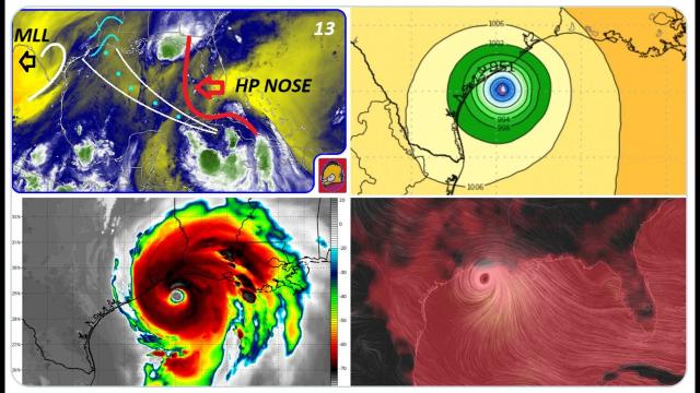
RED ALERT! Houston, we might have a problem! Hurricane Laura is intensifying & wobbling West!
Description
It would only take two major wobbles west to put Hurricane Laura into Galveston and Houston. Please be prepared & ready to evacuate.
God bless everyone.
T LEWISON
5430 BIRDWOOD RD. #416
HOUSTON TEXAS 77096
https://www.paypal.me/THORnews
https://venmo.com/TEric-Lewison
$THORnews on CashApp
https://www.patreon.com/thornews
TWC outlook
https://weather.com/storms/hurricane/news/2020-08-25-hurricane-laura-forecast-texas-louisiana
Hurricane Laura Is Strengthening and Expected to Strike Upper Texas, Louisiana Coasts as Category 3
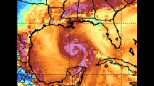
Laura strengthened into a hurricane Tuesday morning in the southern Gulf of Mexico.
Conditions in the Gulf of Mexico should allow Laura to strengthen significantly.
Laura is predicted to become a major hurricane prior to landfall on the upper Texas or southwest Louisiana coasts.
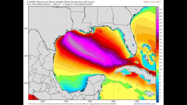
Life-threatening storm surge and damaging winds will affect areas near where Laura makes landfall.
Laura is also an inland flood risk as far north as Arkansas or southern Missouri.
Isolated tornadoes are also expected from Laura.
Hurricane Laura is intensifying over the Gulf of Mexico and expected to become a major hurricane prior to striking the upper Texas or southwest Louisiana coasts late Wednesday or early Thursday. Life-threatening storm surge and destructive winds will batter the coast and a threat of flooding rain and strong winds will extend well inland.
Residents along the upper Texas and southwest Louisiana coasts should prepare now for a hurricane strike. Follow any evacuation orders issued by local or state officials.
Current Status
Laura became the fourth hurricane of the 2020 Atlantic hurricane season Tuesday morning, based on measurements taken by NOAA hurricane hunter aircraft.
Laura has prompted hurricane and storm surge warnings for the Gulf Coast.
A storm surge warning is in effect from San Luis Pass, Texas, to the mouth of the Mississippi River in southeast Louisiana, including Galveston Bay and areas inside the Port Arthur, Texas, hurricane flood protection system.
This means a life-threatening storm surge is expected in the next 36 hours. Residents in these areas should heed all evacuation orders and instructions from local emergency management and take necessary precautions to protect life and property.
A hurricane warning is now in effect from San Luis Pass, Texas, to Intracoastal City, Louisiana. This includes Galveston, parts of the east Houston metro area, Beaumont and Port Arthur, Texas, Lake Charles, Louisiana, and several additional inland counties and parishes of east Texas and southwestern Louisiana extending north of Interstate 10.
Hurricane warnings are typically issued 36 hours before tropical storm-force winds are expected to begin, making storm preparations difficult.
Tropical storm warnings extend into the rest of the Houston metro area and extend east into south-central and southeast Louisiana, including the city of Lafayette. This means tropical storm conditions are expected with the next 36 hours.
A storm surge watch extends as far east as Ocean Springs, Mississippi, and as far west as Freeport, Texas. This watch includes Lake Pontchartrain, Lake Maurepas and Lake Borgne for areas outside of the southeast Louisiana Hurricane and Storm Damage Risk Reduction System. This watch means life-threatening inundation of water moving ashore over land is possible within the area in 48 hours or less.
A hurricane watch extends as far north as Lufkin, Texas, and tropical storm watches extend as far north as the Interstate 20 corridor from near Tyler, Texas, to Shreveport and Monroe, Louisiana.
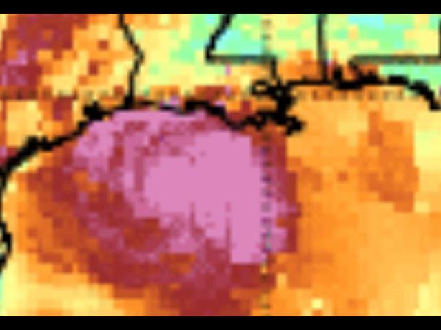
Laura is centered less than 450 miles southeast of Lake Charles, Louisiana. It's tracking to the west-northwest at just over 15 mph.
Satellite imagery shows the storm is becoming increasingly organized as it moves into a favorable environment for strengthening in the Gulf of Mexico.
U.S. Hurricane Threat
The National Hurricane Center (NHC) forecast shows Laura will curl more to the northwest by Wednesday.
It's possible Laura could undergo a period of rapid intensification according to the NHC. That means it could have a wind speed increase of at least 35 mph in 24 hours.
aura is predicted to become a major hurricane - Category 3 or stronger on the Saffir-Simpson Hurricane Wind Scale - prior to making landfall somewhere along the southwest Louisiana or upper Texas coasts Wednesday night or early Thursday morning. Conditions are expected to deteriorate in these areas by Wednesday.
There may still be subtle, yet important changes to the track and intensity forecast.
For instance, any westward shift of the track could increase the threat of Laura's strongest winds, storm surge and rain in the Houston-Galveston metro area. As a result, residents in these areas should prepare for a potential hurricane strike.
"