RED ALERT! TS Laura could hit Houston & Galveston or Louisiana as a major Hurricane
Description
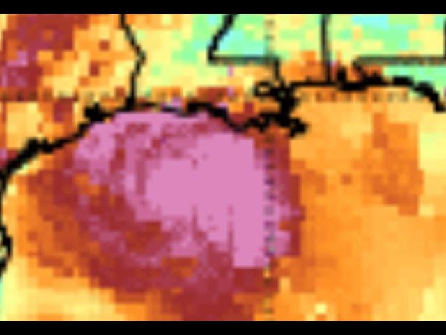
Models have been wonky but there is quite a bit of solid data pointing toward Laura becoming a strong or major hurricane & heading to central Texas or West Louisiana Wednesday or Thursday.
Be ready.
God bless everyone,
T LEWISON
5430 BIRDWOOD RD. #416
HOUSTON TEXAS 77096
https://www.paypal.me/THORnews
https://venmo.com/TEric-Lewison
$THORnews on CashApp
https://www.patreon.com/thornews
TWC outlook
https://weather.com/storms/hurricane/news/2020-08-24-tropical-storm-laura-hurricane-forecast-texas-louisiana
Tropical Storm Laura Poses an Increasing Major Hurricane Danger For the Texas and Louisiana Coast
Tropical Storm Laura will spread flooding rainfall to Cuba, Jamaica and the Cayman Islands.
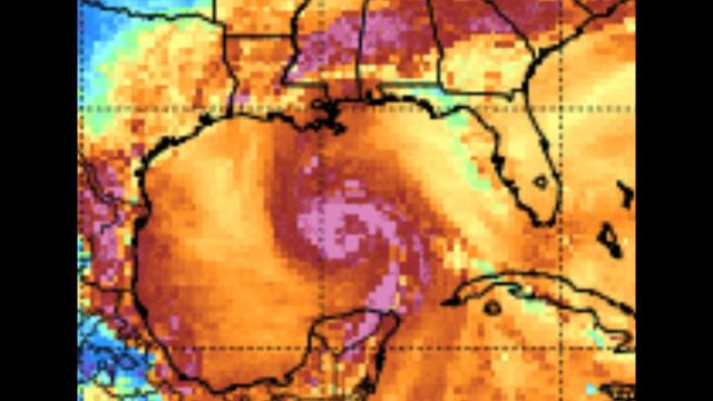
Laura will enter the Gulf of Mexico by early Tuesday.
Conditions in the Gulf of Mexico could allow Laura to strengthen significantly.
The intensity and track is still uncertain for when Laura approaches the U.S. Gulf Coast.
However, there is an increasing hurricane danger for parts of the Texas and Louisiana coasts by midweek.
It's too early to determine specific details on the impacts the Gulf Coast will see.
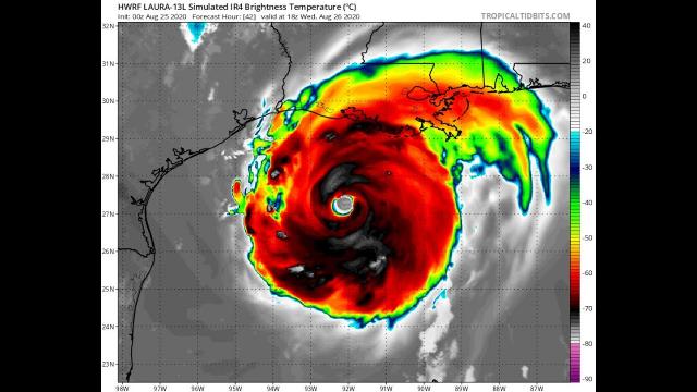
Tropical Storm Laura could strengthen quickly into a major hurricane in the Gulf of Mexico with a significant threat of storm surge, strong winds and flooding rainfall to parts of the Louisiana and Texas coasts later this week. However, its exact forecast track and intensity as it approaches the Gulf Coast is still highly uncertain.
Current Conditions
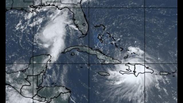
Laura is currently centered near central Cuba. Flooding rainfall and gusty winds will continue in parts of Cuba and Jamaica today.
Laura will continue to track west-northwest through Tuesday with heavy rainfall and tropical-storm-force winds spreading along its path into Cuba and parts of the Florida Keys.
Tropical storm warnings extend from Cuba to parts of the Cayman Islands and the middle and lower Florida Keys.
But then it's expected to enter the Gulf of Mexico by early Tuesday morning, where intensification is forecast to begin. It's possible that Laura could undergo a brief period of rapid intensification, according to the NHC. That means it could have a wind speed increase of at least 35 mph in 24 hours.
There are two main factors favoring intensification.
Water temperatures in the Gulf of Mexico are generally warmer than average, roughly 86 to 88 degrees Fahrenheit, plenty warm enough to fuel intensification of Laura.
Laura's path is expected to take it over the Loop Current, a current of deeper warm water flowing north from the northwest Caribbean Sea into the southeast Gulf of Mexico. That would be an even more impressive reservoir of fuel for Laura to gain strength.
These general ingredients occurring in the heart of the hurricane season suggests a potential for Laura to intensify to a stronger, possibly major - Category 3 - hurricane before it nears parts of the Texas and Louisiana Gulf Coasts sometime later Wednesday or early Thursday.
Keep in mind that there will likely be additional changes to the track and intensity forecast over the next few days.
"Users are again reminded to not focus on the exact details of the track or intensity forecasts as the average NHC track error at 72 hours is around 100 miles and the average intensity error is around 15 mph," the NHC said early Monday morning.
The bottom line is that Laura is likely to bring storm surge, rainfall and wind impacts to parts of Texas and/or Louisiana Gulf Coasts by midweek. As of right now, the center of Laura is most likely to make landfall somewhere from the upper Texas coast to the southwest or central Louisiana coast. But keep in mind that a hurricane isn't just a point. Impacts will extend far from where the center eventually moves inland.
Depending on its exact track, Laura could also spread rain and wind impacts farther inland through parts of the lower Mississippi Valley and Ohio Valley late this week.
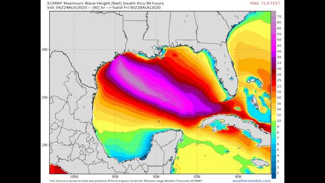
The NHC forecast indicates that 5 to 10 inches of rainfall, with maximum amounts of 15 inches, is possible from portions of the west-central U.S. Gulf Coast to the lower Mississippi Valley during the second half of this week, with the potential for flash flooding to extend well inland.
All interests along the Texas and Louisiana coasts should monitor this forecast closely and make preparations for a possible hurricane strike. Check weather.com for updates.
Caribbean Forecast
Heavy rainfall will be the primary impact from Laura in the northern Caribbean. The rainfall could cause flash flooding and mudslides, particularly in Cuba and Jamaica through Monday.
Rainfall totals of 4 to 8 inches are possible in Jamaica and Cuba, with isolated totals of 12 inches.
The Cayman Islands is expected to receive 2 to 4 inches of rainfall, with maximum amounts of 6 inches in some spots.
Up to 2 inches of rain may fall in the Florida Keys, Turks and Caicos and the northwest Bahamas.
Gusty winds from Laura could also cause tree damage and knock out power in some areas.