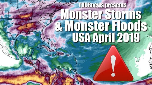
Monster Storm to hit USA. It is the 1st of 5 storms in two weeks & WoW the Sun.
Description
With a wild looking Sunspot/Filament complex turning our way and the Eris alignment in 9 days, I'd buckle up and look alive. We've got some big challenges in April.
God bless everyone,
T
https://www.venmo.com/TEric-Lewison
https://www.paypal.me/thornews
send mail to
5430 Birdwood Rd. #416
Houston, Tx 77096
Leakcon 2019
Denver May 18th and 19th
LeakCon2019 is SOLD OUT but you can still be there bu purchasing the livestream.
It's the only way...
LeakCon2019 Live-Stream https://bit.ly/2TTbPIq
https://leakcon2019.ticketspice.com/leakcon2019
latest crankywxguy blog
http://www.stormhamster.com/entry2/e040819.htm
the danielle banks video
https://weather.com/storms/winter/news/2019-04-09-how-winter-storm-wesley-could-set-april-pressure-snowstorm-records
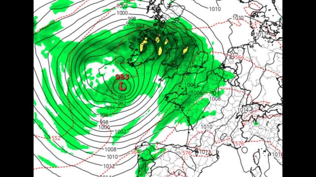
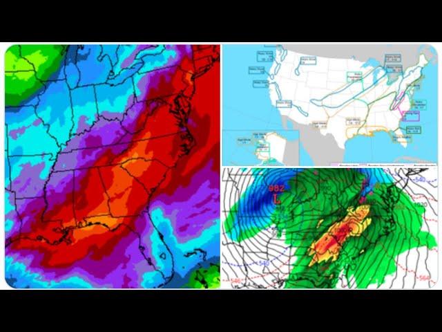
Wesley's low-pressure center could flirt with all-time April low-pressure records in parts of the Plains, according to data compiled by NOAA Weather Prediction Center meteorologist David Roth.
Computer forecast models indicate the area of low pressure will bottom out in the upper-970s to lower-980s millibars. Record-low pressures for April in the region where Wesley is forecast to track when the system is at its strongest – generally between Kansas and southern Nebraska – range from about 978 to 982 millibars, so some of these records could be in jeopardy Wednesday or Thursday.
But it's not clear this storm will be strong enough to be deemed a "bomb cyclone" because its atmospheric pressure might not meet the meteorological definition for bombogenesis, a 24-millibar pressure drop in 24 hours or less.
Wesley may bring to mind a storm almost exactly one year ago, Winter Storm Xanto, which dumped over a foot of snow in Sioux Falls, South Dakota, and the Twin Cities and up to 33 inches of snow in northeastern Wisconsin.
In some parts of Minnesota and South Dakota, Wesley could flirt with all-time April snowstorm records, including the Twin Cities, which set their April record during Xanto last year, when 15.8 inches piled up between April 13-16.
All it would take is more than 7.6 inches Wednesday night through early Friday for Minneapolis/St. Paul to see one of its 10 heaviest April snowstorms.
Some parts of South Dakota and southwestern Minnesota could pick up more than 20 inches of snow from Wesley.
Wesley will be an intense low-pressure system that could flirt with all-time April low-pressure records in parts of the Plains, according to data compiled by NOAA Weather Prediction Center meteorologist David Roth. That said, it's not clear this storm will be strong enough to be deemed a "bomb cyclone" since its atmospheric pressure might not meet the meteorological definition for bombogenesis, which is a 24-millibar pressure drop in 24 hours.
Blizzard warnings have been issued by the National Weather Service from parts of northeastern Colorado to southeastern Wyoming, western and central Nebraska, far northwestern Kansas, South Dakota and southwestern Minnesota. This includes Denver; Cheyenne, Wyoming; Scottsbluff, Nebraska; and Pierre, South Dakota.
Various winter storm watches and warnings and winter weather advisories have also been posted from portions of the northern and central Rockies into the upper Mississippi Valley and northern Great Lakes.
By Friday, Wesley should be weakening, with lingering snow in upper Mississippi Valley and northern Great Lakes. As it reaches the East, it will mainly produce rain and thunderstorms, even into northern New England.
Forecast Impacts
There is still some uncertainty in the exact placement and amounts of snow from Winter Storm Wesley, but a general scenario is coming into focus.
At least 6 inches of snow now appears likely in a swath from Wyoming and northeastern Colorado to northern Michigan.
Within that swath, it's likely at least a foot of snow will accumulate over parts of South Dakota, northern Nebraska, southern Minnesota and northwestern Wisconsin. A few locations in this zone may see accumulations of 20 to 30 inches.
Minneapolis/St. Paul could see one of its 10 heaviest April snowstorms if it picks up more than 7.6 inches Wednesday night through early Friday.
Denver may also see several inches of snow, along with blizzard conditions, later Wednesday into Thursday.
The combination of strong winds and snow will create blizzard conditions in parts of the Plains and Midwest Wednesday into early Friday, making travel treacherous, if not impossible, in parts of Minnesota, northern Iowa, South Dakota, Nebraska, Wyoming, northeastern Colorado and northwestern Kansas. Road closures are possible, potentially including along stretches of interstates 29, 70, 80 and 90. Snow drifts of multiple feet are possible in some areas.
Accumulation of wet, heavy snow and wind may lead to power outages and tree damage in some spots, something typical of strong early- and late-season snowstorms. There could also be wind damage in areas that receive little or no snow, something we saw in last month's bomb cyclone.