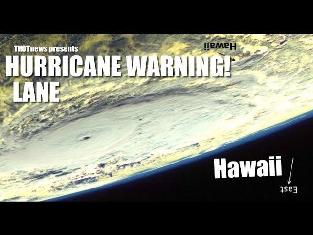
Hurricane Hector TS Warning 4 Hawaii - close & strong Hurricane, not a direct hit
Description
A tropical Storm warning has been issued for Hawaii.
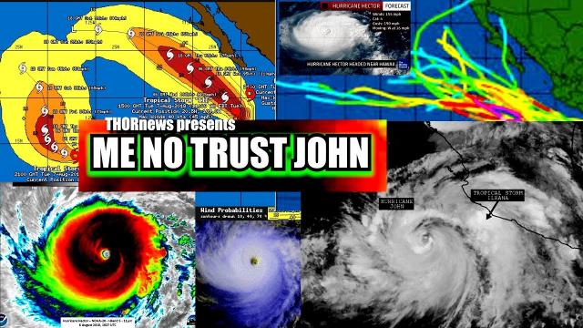
10:00 pm Hawaii time - August 7th 2018. Hector looks like a strong Category 3 Hurricane. Estimated Wind gusts between 60 to 125 mph is the spread between Euro & GFS models. 1 inche to 5 inches of rain is the spread over 10 days on rain. The wind gusts predicted for the main land range from 20 to 40 miles per hour according to GFS & Euro.
I'd guess 10 inches of rain over 10 days, 60-70+ mph wind gusts and some radical waves. projected to pass 100-150 miles away.
It should be a good storm but not too bad. I'll keep you posted if the situation changes. unless i fall asleep. I've been working for about 17 hours now. but Hurricanes charge me up. Stay safe. Be cool. Stay cool. Aloha. God bless everyone,
T
https://www.paypal.me/THORnews
Tshirts
https://hitthebuttonbaby.com/
THORNEWS
PO BOX 35946
HOUSTON TEXAS
77235-5946
the crankywxguy blog
http://www.stormhamster.com/entry/e073118.htm
the wave master
https://dabuh.com/
http://www.hawaiinewsnow.com/story/38797281/hector-still-category-4-hurricane-expected-to-pass-south-of-islands
Tropical storm warning in effect for Big Island as Hector moves west
HONOLULU (HawaiiNewsNow) -
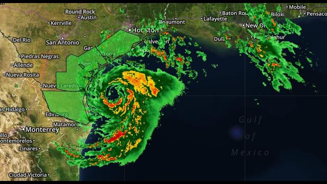
A tropical storm warning has been issued for the Big Island as Hurricane Hector continues its march westward as a strong Category 4 storm, bringing the threat of monster surf and strong winds starting late Tuesday and into Wednesday.
A tropical storm warning means that tropical storm conditions are expected.
At 8 p.m. Tuesday, Hector was packing maximum sustained winds of 130 miles per hour, with occasional higher gusts.
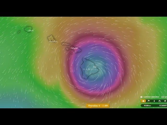
On the current forecast track, the center of Hector is slated to pass 100 to 150 miles south of the Big Island on Wednesday. Forecasters note that hurricane-force winds extend up to 40 miles from the center of the storm, and tropical-storm-force winds extend outward up to 115 miles.
"Far northern fringes of the hurricane will brush the Big Island Wednesday," forecasters said in an update.
According to the Central Pacific Hurricane Center, the center of the hurricane was located about 315 miles southeast of Hilo on Tuesday night. Any deviation northward could bring Hector close enough to impact the Big Island.
Wednesday.
MORE
HNN Hurricane Center
A tropical storm warning means that tropical storm conditions are expected.
At 8 p.m. Tuesday, Hector was packing maximum sustained winds of 130 miles per hour, with occasional higher gusts.
On the current forecast track, the center of Hector is slated to pass 100 to 150 miles south of the Big Island on Wednesday. Forecasters note that hurricane-force winds extend up to 40 miles from the center of the storm, and tropical-storm-force winds extend outward up to 115 miles.
"Far northern fringes of the hurricane will brush the Big Island Wednesday," forecasters said in an update.
According to the Central Pacific Hurricane Center, the center of the hurricane was located about 315 miles southeast of Hilo on Tuesday night. Any deviation northward could bring Hector close enough to impact the Big Island.
Big Island officials are taking precautions in advance of the storm nearing the state. The Mayor's office has issued an emergency proclamation for Hawaii Island.
The storm was moving west at roughly 16 mph.
Possible impacts to the islands include:
Surf: Swells generated by Hector are forecast to reach southeast and east shores of the Big Island and Maui late Tuesday.
A high surf warning has been issued for east-facing shores of Hawaii Island for 12-13 foot waves.
A high surf advisory has been issued for east-facing shores of Maui for 6-10 foot surf. Both are in effect through 6 p.m. Wednesday. Higher than usual tides will combine with the large surf to increase the threat of coastal inundation.
Wind: Tropical-storm-force winds (39 to 73 mph) are possible across the Big Island late Tuesday and Wednesday.
Rain: Rains from the deep tropical moisture surrounding Hector could affect the Puna and Kau Districts of Hawaii Island, and some of those rain showers may be locally heavy at times, especially on east and southeast-facing slopes.
Over the next few days, Hector is expected to gradually weaken.


Comments