Hawaii & the East Coast to be hit by Hurricanes September 12th-ish?
Description
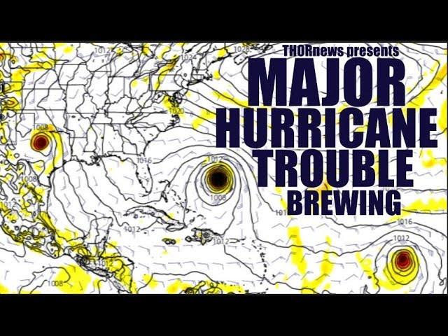
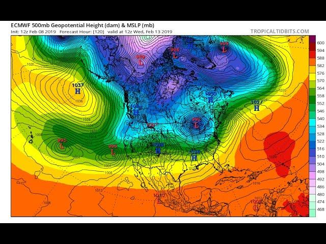
One week from now could be the absolute most dangerous weekend in American history with Hurricane Olivia threatening to make landfall on Hawaii & Hurricane Florence threatening to strike the East Coast. Plus the lowest pressure system ever recorded in the next typhoon to plague the west pacific. Don't be scared. Have a Plan. Be Prepared. God bless everyone. Stay Cool. - T
https://www.paypal.me/THORnews
Tshirts
https://hitthebuttonbaby.com/
THORNEWS
PO BOX 35946
HOUSTON TEXAS
77235-5946
the crankywxguy blog
http://www.stormhamster.com/entry/e090618.htm
the wave master
https://dabuh.com/
https://www.youtube.com/user/MrMBB333
https://weather.com/storms/hurricane/news/2018-09-06-hurricane-florence-atlantic-ocean-bermuda-us-east-coast
Hurricane Florence Still an Uncertain Threat to Bermuda, U.S. East Coast Next Week
Florence has weakened due to wind shear, but it will reintensify next week.
Florence will generate swells that will begin to affect the U.S. East Coast by this weekend.
There is a large amount of uncertainty when it comes to Florence's path next week.
Interests in Bermuda and along the U.S. East Coast should monitor Florence's forecast.
Hurricane Florence has weakened temporarily over the open Atlantic Ocean, but it will reintensify this weekend and may pose a threat to Bermuda and parts of the U.S. East Coast next week.
As of late Thursday afternoon, Florence was centered more than 1,000 miles east-southeast of Bermuda, moving toward the northwest.
Florence previously underwent rapid intensification, with winds increasing from 75 mph at 11 a.m. EDT Tuesday to 130 mph by 5 p.m. EDT Wednesday. Rapid intensification is defined as an increase in wind speed of at least 35 mph in 24 hours or less.
Almost immediately after that explosive strengthening, Florence was steered into strong southwesterly winds aloft, providing wind shear – a change in wind direction and/or speed with height – that is disrupting Florence's small core, stepping down its intensity.
Florence is not an immediate threat to any land areas through Monday.
However, Florence will generate swells that will begin to affect Bermuda on Friday and the U.S. East Coast by this weekend, the National Hurricane Center said. Swells will also propagate to north and northeastward-facing coasts of the Lesser Antilles, Puerto Rico, Hispañola, the Turks and Caicos and the Bahamas into this weekend.
These swells will produce life-threatening surf and rip current conditions at these beaches.
Warm ocean temperatures and decreasing wind shear this weekend and into early next week should allow Florence to reintensify.
There remains a rather large uncertainty in Florence's potential track relative to Bermuda early next week since the exact evolution of the upper-level weather pattern that steers Florence is uncertain.
One way to see the uncertainty is through the variety of computer model forecast tracks through the next six days, shown below.
The closer together the lines are indicates more forecast confidence, and increasing distance between the lines indicates a lack of certainty of the upcoming steering pattern by the models.
Over 800 miles separate the northernmost models from the southernmost models, which is why our confidence is very low beyond a couple of days.
There is no hurricane watch for Bermuda at this time. It appears the timing of Florence's potential impact would be roughly Tuesday. But, again, it is far from certain if Bermuda will take a direct hit at all.
Uncertain U.S. East Coast Threat Next Week
Beyond that, there is a chance that Florence could move on a path that would take it close to, or directly strike, at least parts of the East Coast of the United States later next week.
For now, there is a large amount of uncertainty in this long-range forecast, but we will continue to monitor Florence for that possibility and provide more updates in the coming days.
Florence will move toward the west-northwest along the southern periphery of a high-pressure system located to its north through Saturday.
A possible fork in the road comes in play early next week.
That area of high pressure may be eroded by a subtle southward plunge of the jet stream moving over eastern Canada and the far northwestern Atlantic Ocean. That could pull Florence more toward the northwest, feeling the influence of that jet stream plunge.
On the other hand, if Florence doesn't feel as much influence from the jet stream, it could remain tracking farther west as another area of high pressure builds over the western Atlantic Ocean. If that happened, it could bring Florence uncomfortably close to parts of the East Coast mid- to late next week.