Flooding & Wildfires - West. Central. South. & NorthEast
Description
God bless everyone,
T
https://www.paypal.me/THORnews
Tshirts
https://hitthebuttonbaby.com/
THORNEWS
PO BOX 35946
HOUSTON TEXAS
77235-5946
the crankywxguy blog
http://www.stormhamster.com/entry/e081318.htm
the wave master
https://dabuh.com/
https://www.accuweather.com/en/weather-news/wet-weather-to-perpetuate-flood-threat-in-the-northeast-early-this-week/70005765
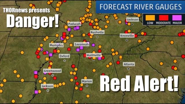
Dangerous flooding that has already hit across portions of Ohio, Pennsylvania, New Jersey, New York state and Massachusetts will worsen over the coming days as rounds of heavy rain inundate the northeastern United States.
During Friday night, flooding downpours hit portions of Ohio and southwestern Pennsylvania.
On Saturday, portions of northern New Jersey and the New York City area were hit hard by torrential rain and flooding.
During Monday morning, multiple water rescues were performed in southeastern Pennsylvania. In Bradford County, Pennsylvania, water was flowing over a portion of U.S. Route 220. Flooding occurred in Monmouth County, New Jersey.
More flooding is likely from the latest, slow moving storm to affect the region.
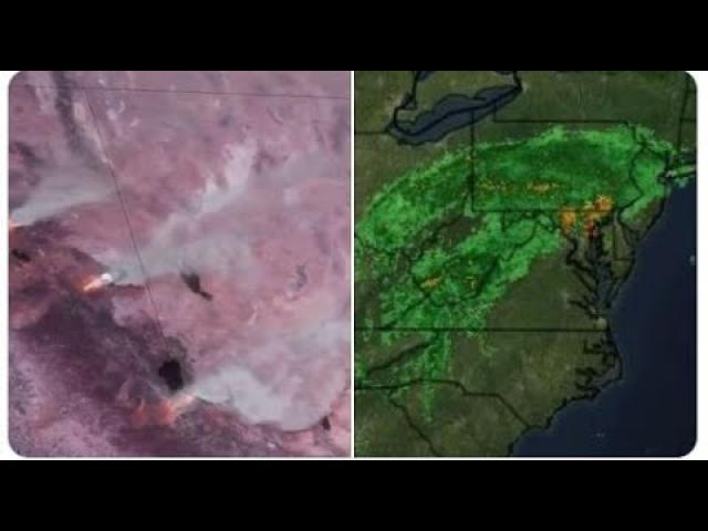
A system is expected to track slowly across the Northeast through Tuesday, promoting widespread wet weather.
While showers and thunderstorms will tend to fill-in from Ohio to New Hampshire and South Carolina into Monday night, communities from Pennsylvania to New Jersey and New York state and southwestern New England should brace for another round of torrential rainfall and flooding.
"Whether 5 inches of rain falls in as many days or an inch of rain falls in an hour, enough rain is expected to fall to lead to rising rivers and urban and small stream flooding," warned AccuWeather Senior Meteorologist Alex Sosnowski.
"The rain may lead to delays and cancellations of some sporting events and could make moving into a new home, apartment or dorm quite difficult," Sosnowski said.
Through Tuesday, some places could receive several inches of rain, which would have trouble being absorbed by the already saturated ground.
Unlike the rainy pattern a couple of weeks ago, a number of coastal areas will not be spared from the worst of the rain this time.
Anyone planning a trip to any coastal community from Ocean City, Maryland; to Jones Beach, New York; will need to find indoor entertainment for the first couple days of the week.
While Tuesday will be sunnier at these locations to start, storms could threaten beachgoers later in the day. Any storms on Monday and Tuesday could contain gusty winds, downpours and lightning, making the beach a dangerous spot to be caught without shelter.
Poor drainage and low-lying areas flood the quickest, so anyone living, working or traveling through urban areas will need to be on the lookout for rapidly-rising water.
Motorists should not attempt to traverse a flooded roadway. It is impossible to tell how deep the water is, and the road underneath may have washed out. You are not only putting your vehicle at risk, but also your life and the lives of others.
For the latest forecast updates and flood watches and warnings for your area, download the free AccuWeather app.
"Since the pattern is looking more likely to remain wet through August, there may be a heightened concern for significant flooding as the hurricane season peaks during September and early October," Sosnowski said.