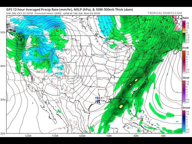
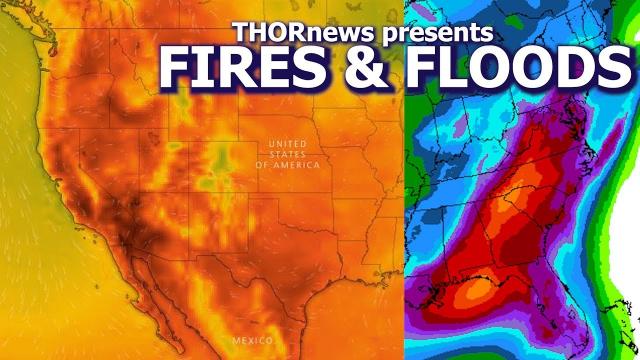
East Coast Floods & West Coast Heat & Fires is the next 48 Hour forecast
Description
and yes, of course there will be trouble in between.
God bless everyone,
T
https://www.paypal.me/THORnews
Tshirts
https://hitthebuttonbaby.com/
THORNEWS
PO BOX 35946
HOUSTON TEXAS
77235-5946
the crankywxguy blog
http://www.stormhamster.com/entry/e080118.htm
the wave master
https://dabuh.com/
articles on storms
https://www.accuweather.com/en/weather-news/flooding-rainfall-to-threaten-eastern-us-through-the-end-of-the-week/70005663
Flooding rainfall to threaten eastern US through the end of the week
More torrential downpours will swamp the Appalachians and are forecast to push to the Atlantic coast into the start of the weekend.
Flooding will continue to be a major concern. Expect low-lying and poor drainage flooding to occur first during periods of heavy rainfall.
"With more heavy rainfall ahead, additional flash flooding along streams and creeks will be likely through the end of the week," warned AccuWeather Meteorologist Kyle Elliot.
"Through Friday, areas hit repeatedly by drenching downpours may receive an additional 4-8 inches of rain," Elliott said.
Remember to turn around, don't drown.
"Motorists traveling near small streams should pay close attention to water levels and turn around if water covers the roadway ahead," Elliott said.
Flooding is likely to escalate to some of the rivers in the region, especially those with headwaters in the Appalachians.
Stretches of the Susquehanna, Juniata, Potomac, Elk, Kanawha, Shenandoah and Allegheny rivers have been on the rise this week.
Flooding was reported in east-central Alabama on Thursday afternoon causing some roads to become impassable.
@NWSBirmingham @postpaper @spann Many roads are flooded in the Southeast part of Cherokee County. Don't attempt driving down these roads. CR 126 and CR 185. #alwx #bmxwx pic.twitter.com/YGA3w7A5bi
— Matt Teal (@Matt_CherokeeCo) August 2, 2018
"Late this week, minor to moderate flooding is possible along portions of these rivers and others where there are no levees," according to AccuWeather Senior Meteorologist Alex Sosnowski.
Communities that are especially vulnerable to flooding may face evacuation notices as water levels rise.
Download the free AccuWeather app to track storms and stay up to date on the latest local flood watches and warnings.
While rounds of drenching rain and flooding problems escalate over the Appalachians and Piedmont areas into Friday, downpours are forecast to spread eastward during Thursday night, Friday and Friday night.
Areas that have not received much rain early this week, such as areas near and east of Interstate 95 and the beaches, are likely to join in on the Appalachian's frequent, locally heavy rainfall into the start of the weekend.
Since much of the I-95 corridor and the immediate Atlantic coast is highly urbanized with extensive development and paved surfaces, the risk of flash flooding will increase. At the very least, motorists may face areas of flooded underpasses and ponding on stretches of highways and city streets.
Intertwined in the likelihood of flooding, some of the strong thunderstorms that develop can have damaging consequences.
While not as widespread as Wednesday's severe thunderstorms that stretched from Atlanta to New York City, storms in these areas on Thursday will still be capable of producing damaging wind gusts. Trees and power lines will topple easily in the heavily saturated soil.
"Anywhere the sun pops out for a few hours along the Atlantic seaboard, the risk of gusty thunderstorms crashing in will be greatest during the afternoon and evening hours through Friday," according to AccuWeather Lead Long-Range Meteorologist Paul Pastelok.
Following a couple weeks of relentlessly wet weather in the eastern United States, a new weather pattern is finally on the horizon. The drying trend will progress eastward during Friday night and Saturday.
The period from Sunday to Tuesday will be much less stormy, but it may feel like a steam bath.
Communities impacted by road closures and property damage due to the heavy rainfall will be able to begin cleanup efforts this coming weekend.