East Coast! Be Prepared! Models have MONSTER HURRICANE trending West
Description
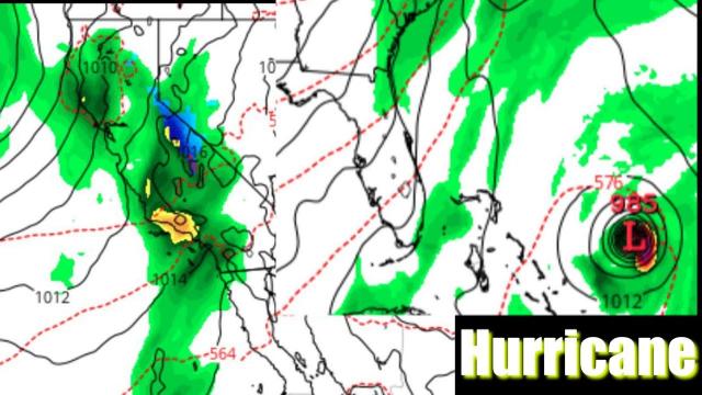
Models are already trending West on what is sure to be a monster Hurricane. We've got 2 weeks to watch & prepare. There is no reason to be scared. Plan & Prepare Now. Stay Cool. God Bless Everyone.
T
https://www.paypal.me/THORnews
Tshirts
https://hitthebuttonbaby.com/
THORNEWS
PO BOX 35946
HOUSTON TEXAS
77235-5946
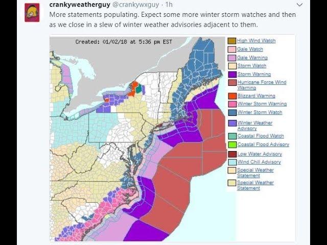
the crankywxguy blog
http://www.stormhamster.com/entry/e08318.htm
the wave master
https://dabuh.com/
https://www.usatoday.com/story/news/nation/2018/08/29/hurricane-season-coming-life-atlantic/1132669002/
'Weather models have flipped the switch': Hurricane season coming to life in the Atlantic
The sleeping giant may be about to awaken.
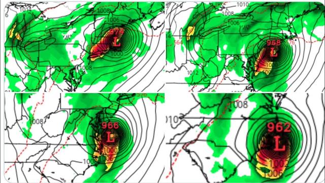
Hurricane activity in the Atlantic Ocean, Caribbean Sea and Gulf of Mexico is forecast to ramp up over the next couple of weeks. "Weather models have flipped the switch on the Atlantic hurricane season and see multiple areas of development possible, starting mainly this weekend," weather.us meteorologist Ryan Maue said.
One storm could spin up in the Caribbean over the next few days and affect Florida over the Labor Day weekend. Looking further ahead, "there is the potential for two or three tropical features spinning over the Atlantic by the second weekend in September," AccuWeather meteorologist Dan Kottlowski said.
The next tropical storm or hurricane in the Atlantic basin will be called Florence.
One of the reasons for the predicted increase in activity is that wind shear, which tends to rip apart developing hurricanes, appears to be decreasing. "There are signs now that wind shear may drop over a significant part of the Atlantic basin over the next couple of weeks," said AccuWeather meteorologist Bernie Rayno.
It's too early to predict exactly where or when any storm might form or whether a storm will affect land areas.
With the peak of hurricane season close at hand, there are signs that the tropical Atlantic may soon spring to life with the potential for direct impact on the coastal United States in the days ahead: https://t.co/QhcvGMUlltpic.twitter.com/d6Rljc3sox
— AccuWeather (@breakingweather) August 28, 2018
"When models start suggesting tropical cyclone development many days in advance in multiple parts of the Atlantic basin, while they might not be right about exactly when and where, it does indicate that the atmosphere is changing and it’s about to get busy overall for September," Weather Channel hurricane expert Rick Knabb said.
Regardless of what happens this year, 2018 will be hard-pressed to top the calamitous 2017 season, which featured monster hurricanes such as Harvey, Irma and Maria. Overall, 10 hurricanes formed in the Atlantic last year, well above the average of six.
The prediction for a busy September this year follows an unusually quiet August for the Atlantic. For the first time since 2013, no hurricanes formed in August in the Atlantic basin.
"A quiet August does not guarantee a quiet Atlantic hurricane season," said Colorado State University meteorologist Phil Klotzbach. In 1961, he said, no hurricanes formed in August, but four major hurricanes blew up in September.
This innocuous looking patch of clouds needs to be monitored as it steadily moves northwest, with some chance for development. If you live in the Southeast or along Gulf Coast ... stay updated on the forecast. This is not 10 days out. It's this weekend/early next. #flwx#alwxpic.twitter.com/mIrWP51vis
— Greg Postel (@GregPostel) August 29, 2018
September is the peak month for Atlantic hurricanes, recording more