Monster Hurricane Michael hits the Gulf Coast & East Coast in 72 Hours
Description
This is no joke. Be ready. Don't die. Stay cool. God bless everyone T
https://www.paypal.me/THORnews
Tshirts
https://hitthebuttonbaby.com/
THORNEWS
PO BOX 35946
HOUSTON TEXAS
77235-5946
cranky weather guy blog
http://www.stormhamster.com/entry/e100718.htm
Bobbi Storm blog
https://hurricaneharbor.blogspot.com/2018/10/tropical-update-sunday-models-show.html
https://weather.com/storms/hurricane/news/2018-10-07-tropical-storm-hurricane-michael-forecast-gulf-coast-florida
Tropical Storm Michael Strengthening in Northwestern Caribbean Sea, Could Threaten Northeastern Gulf Coast as a Hurricane Midweek
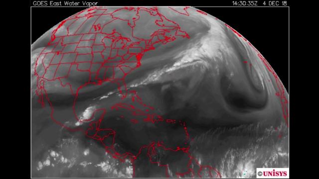
Tropical Storm Michael is strengthening in the northwestern Caribbean Sea.
Michael could threaten the northeastern Gulf Coast as a hurricane in the week ahead.
Storm surge, damaging winds and heavy rain are likely impacts along the northeastern Gulf Coast by midweek.
Tropical storm warnings have been issued for parts of western Cuba and the northeastern Yucatan Peninsula.
Tropical-storm-force winds could arrive on the northeastern Gulf Coast by late Tuesday or early Wednesday.
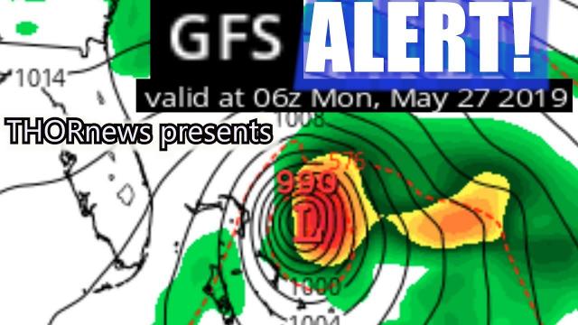
Tropical Storm Michael is strengthening in the northwestern Caribbean Sea and could threaten the northeastern Gulf Coast as a Category 2 hurricane by midweek with dangerous storm surge, damaging winds and heavy rainfall.
Michael is currently centered about 105 miles east-southeast of Cozumel, Mexico, moving slowly toward the north.
Tropical storm warnings have been posted for western Cuba and Mexico's northeastern Yucatan Peninsula, including Cancun. Tropical-storm-force winds (39-plus mph) are expected to first reach the tropical storm warning area Sunday night, making outside preparations difficult or dangerous.
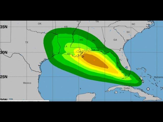
Rainfall totals of 3 to 7 inches are forecast over western Cuba, with 2 to 4 inches over the Yucatan Peninsula and Belize through Tuesday. Isolated maximum amounts of 12 inches are possible in western Cuba.
These downpours could contribute to life-threatening flash flooding and mudslides, particularly in areas of mountainous terrain.
Michael's outer rainbands are also expected to produce 2 to 4 inches of rain across the Florida Keys through Tuesday.
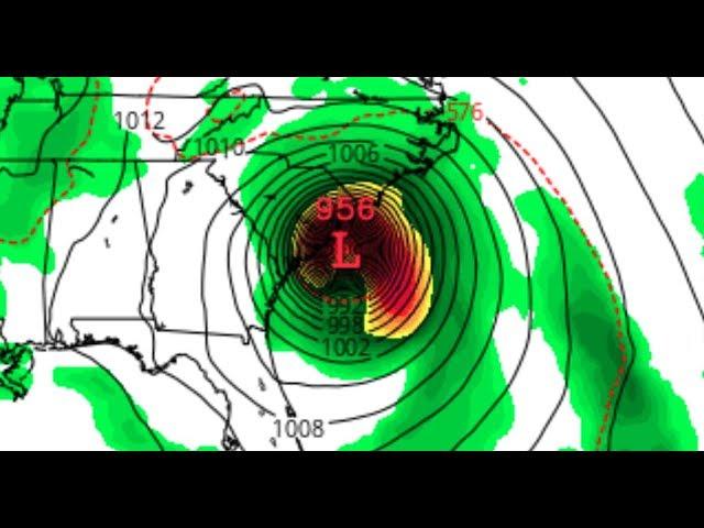
Forecast guidance is unanimous that Michael will be drawn northward through the Gulf of Mexico and pose a threat to the northeastern Gulf Coast by midweek.
Upper-level winds are expected to become more favorable for intensification in the Gulf of Mexico than they are right now, and sea-surface temperatures are above average along Michael's path as well. Both of these factors should assist in a gradual strengthening of Michael into a hurricane before landfall.
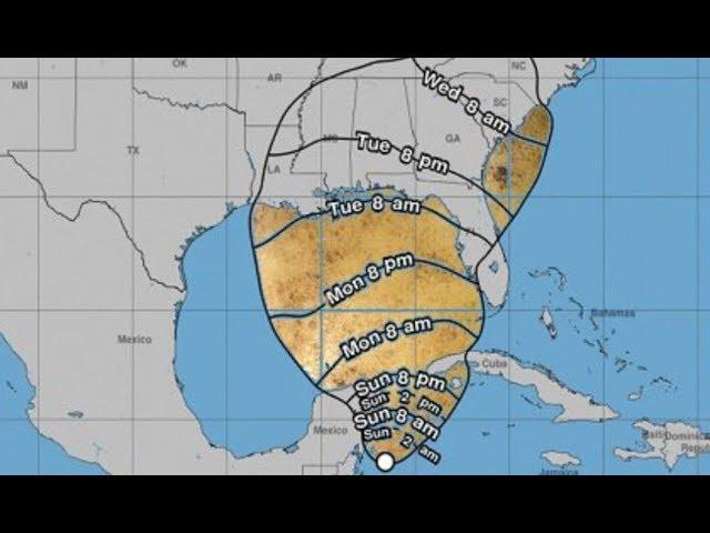
It's too early to determine the exact magnitude of the impacts from this system, but here's a general overview of what we know right now.
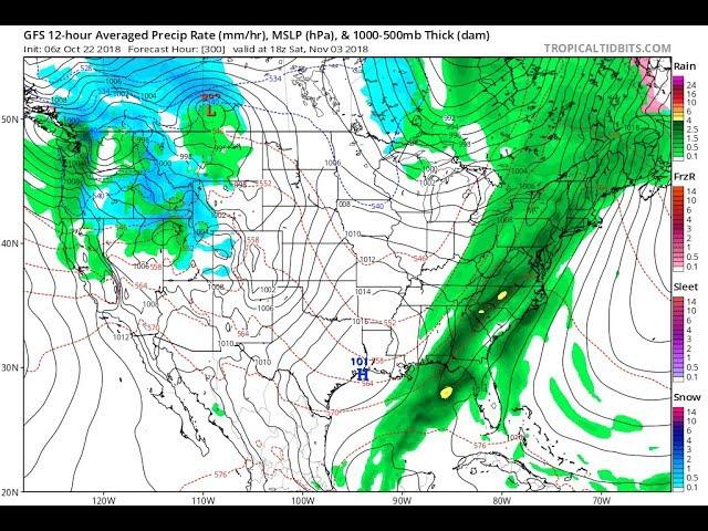
- Timing: Landfall is most likely to occur somewhere between the Florida Panhandle and the Big Bend of Florida Wednesday into Wednesday night. Depending on how quickly or slowly this system moves northward, the center of Michael could approach the Florida Gulf coast as soon as Tuesday night or as late as Thursday morning. After landfall, this system will then move farther inland across the southeastern U.S. into late-week.
- Intensity: The National Hurricane Center is forecasting this system to be a Category 2 hurricane when it makes landfall. However, the intensity forecast is uncertain, and Michael could be weaker or stronger than that at landfall.
- Wind: Tropical-storm-force winds (39-plus mph) are most likely to arrive on the northeastern Gulf Coast Wednesday morning, particularly from southern Alabama to the Florida Panhandle and Big Bend. Winds of that strength could arrive as soon as Tuesday evening, however, depending on how fast Michael moves. Hurricane-force winds (74-plus mph) are possible in a smaller area near where the center moves inland. Tree damage and power outages are possible along the path of Michael near and inland from the northeastern Gulf Coast.