Cristobal will continue to strengthen over central USA into Canada! Our next TS/Hurricane June 21st!
Description
Cristobal still has 100 hours of fuel in its tank & expect our next big storm at the ring of fire eclipse on june 21st.
God bless everyone,
T LEWISON
5430 BIRDWOOD RD. #416
HOUSTON TEXAS 77096
https://www.paypal.me/THORnews
https://venmo.com/TEric-Lewison
$THORnews on CashApp
https://www.patreon.com/thornews
video
https://weather.com/storms/hurricane/news/2020-06-07-tropical-storm-cristobal-landfall-forecast-gulf-coast-sunday
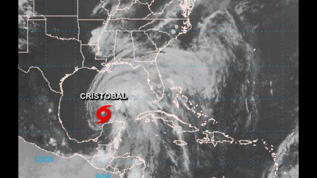
Tropical Storm Cristobal Heads for Gulf Coast Landfall With Flooding Rain, Storm Surge and Gusty Winds
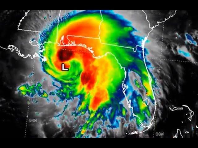
Cristobal will make landfall along the Gulf Coast today.
Tropical storm and storm-surge warnings have been issued.
Rain, wind and coastal flooding may linger into Monday along the northern Gulf Coast.
Cristobal's remnants are expected to move northward into the upper Midwest with heavy rain and gusty winds.
Tropical Storm Cristobal will make landfall on the Gulf Coast today with threats of flooding rainfall, storm-surge flooding, tornadoes and gusty winds. Cristobal is also expected to spread heavy rain and gusty winds through the lower Mississippi Valley and upper Midwest early this week.
The Latest
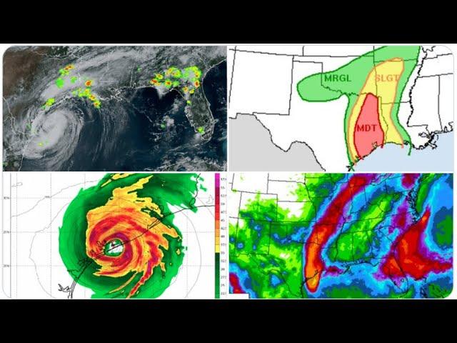
Bands of heavier rain are pushing ashore from southeastern Louisiana to North Florida and South Georgia.
Rainfall rates of 3 to 6 inches per hour Sunday morning triggered significant flash flooding in parts of downtown Jacksonville, Florida, trapping cars. Farther west, one observer near Hopewell, Florida (Madison County), reported 8.17 inches of rain in the 24 hours ending Sunday morning.
A tornado watch has been issued for southern Mississippi and southern Alabama until 5 p.m. CDT. This includes Mobile, Alabama, and Biloxi and Gulfport, Mississippi.
Storm surge has caused water to cover roads near Waveland and Bay St. Louis, Mississippi, where water levels were nearly 4 feet above normal late Sunday morning.
Water levels were running about 5.3 feet above normal tide level Sunday afternoon at Shell Beach, Louisiana, along the Mississippi River Gulf Outlet, southeast of New Orleans near the southern shore of Lake Borgne.
Tropical-storm-force winds (39-plus mph) are located mainly north and east of the center of circulation, as depicted in the orange shading below. Winds have gusted over 40 mph at New Orleans Lakefront Airport.
Maximum sustained winds in Cristobal remain at 50 mph as of Sunday afternoon.
Cristobal is tracking northward with a forward speed of around 5 mph as it moves closer to the Louisiana coastline.
No significant strengthening is forecast prior to the landfall of Cristobal's circulation center Sunday afternoon or early evening.
Current Tropical Alerts
The National Hurricane Center has issued a storm-surge warning from the mouth of the Mississippi River eastward to Ocean Springs, Mississippi, including Lake Borgne. This means there is a danger of life-threatening inundation from rising water moving inland from the shoreline within the specified area.
Storm-surge watches are in effect from east of Morgan City, Louisiana, to the mouth of the Mississippi River.
The NHC has issued a tropical storm warning for parts of the northern Gulf Coast from east of Intracoastal City, Louisiana, to the Walton/Okaloosa County line in Florida, and well inland into eastern Louisiana and southern Mississippi. The warning means that tropical storm conditions (sustained winds of 39 to 73 mph) are expected within 36 hours.
Forecast U.S. Impacts
Storm Surge, Coastal Flood, High Surf
Cristobal's large windfield will drive high surf to the beaches of the entire Gulf Coast, but particularly along and to the east of the track, from Louisiana to western Florida, generating dangerous rip currents and coastal flooding.
The combination of dangerous storm surge and high tides will cause normally dry areas near the coast to be flooded by rising waters moving inland.
Here are the high tides of most concern for coastal and storm-surge flooding along the northern Gulf Coast from Louisiana to western Florida:
-Sunday midday: Peak flooding expected.
-Monday midday: Lingering coastal flooding possible, but not as high as Sunday.
Rainfall Flood Threat
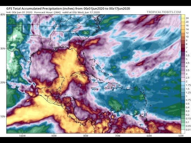
The NHC is predicting the following rainfall totals along the path of Cristobal and its remnants:
-Central Gulf Coast and lower Mississippi Valley: 4 to 8 inches (locally, up to 12 inches)
-Eastern Gulf Coast, upper and mid-Mississippi Valley and Northern Plains: 2 to 4 inches (locally, up to 6 inches)
Heavy rainfall from Cristobal will trigger flash flooding in some areas.
Again, given the storm's lopsided nature, the heaviest rain and highest flood threat are expected along and well to the east of its path from Louisiana to at least the Florida Panhandle.
NOAA's Weather Prediction Center issued a rare "high risk" of excessive rainfall and flooding through early Monday in southeastern Louisiana and southern Mississippi, including New Orleans.