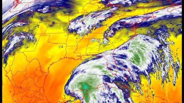
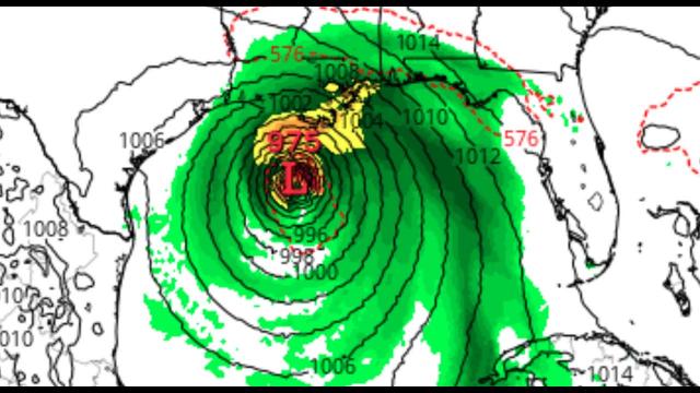
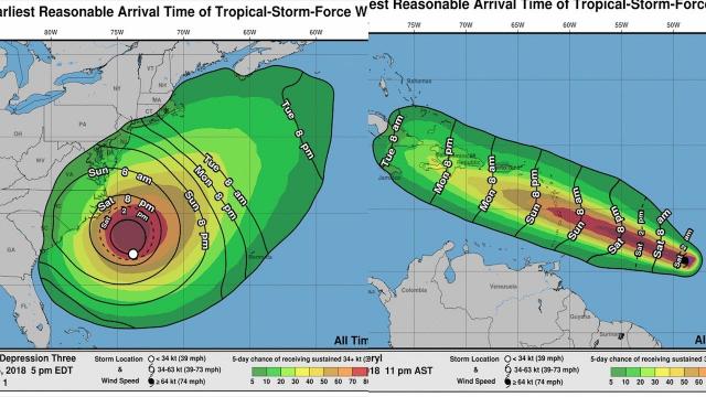
ALERT! Invest 93L is Now Tropical Depression 3 & will soon be Monster Hurricane Cristobal imho.
Description
regardless of intensity this storm is going to be HUGE.
God bless everyone,
T LEWISON
5430 BIRDWOOD RD. #416
HOUSTON TEXAS 77096
https://www.paypal.me/THORnews
https://venmo.com/TEric-Lewison
$THORnews on CashApp
https://www.patreon.com/thornews
video on
https://weather.com/storms/hurricane/news/2020-05-31-watching-gulf-of-mexico-tropical-depression-storm-development-june
Gulf of Mexico an Area to Watch For Possible Development of a Tropical Depression or Storm This Week
A tropical depression or tropical storm may form late week in the Gulf of Mexico.
It is too soon to be certain it will form and, if so, where it will track.
The Gulf of Mexico is a favored area for development in June.
This may be spawned by a large system called a Central American Gyre and the remnants of a former eastern Pacific tropical storm.
The gyre and tropical storm remnants could produce dangerous flooding in Mexico and Central America.
A tropical depression or storm could form in the western Gulf of Mexico this week as the Atlantic hurricane season officially begins.
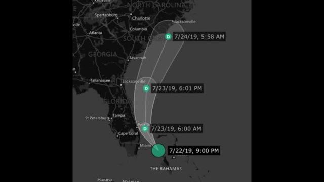
We've already checked Arthur and Bertha off this season's list, making this the sixth Atlantic hurricane season in a row with at least one named storm before the official June 1 kickoff. The next storm to form in the Atlantic basin would be given the name Cristobal.
The National Hurricane Center has highlighted an area for possible tropical development in the southwest Gulf of Mexico, as noted by the circle below. Right now, there is a medium chance of development in this area during the next five days, but those odds could increase or decrease in the week ahead.
It remains too soon to determine where this potential system might track if it does form. There is a chance it could remain stuck in the vicinity of the southwest Gulf and Mexico, or it could eventually track northward through the western Gulf toward the U.S.
So for now, check back with us at weather.com for the latest on this potential tropical system. If anything, this is a reminder to refresh or develop your hurricane plan now.
Incidentally, we could be flirting with the record earliest third named Atlantic storm, which is currently held by Tropical Storm Colin on June 5, 2016.
Potential Development Triggers: Amanda's Remnants and Central American Gyre
This tropical development may be spawned from something called a Central American Gyre, or CAG. This "gyre" is a large, broad area of low pressure that often forms in late spring and early fall over Central America and the western Caribbean Sea.
One such CAG has developed and will park itself over far southeast Mexico and Central America through the week ahead.
The key here is that these CAGs can spawn tropical storms in the Caribbean Sea, Gulf of Mexico or eastern Pacific Ocean.
Tropical Storm Amanda formed from this CAG in the eastern Pacific near the coast of Guatemala this weekend. It's weakened to a tropical depression over Central America where it will eventually dissipate, but the leftover energy and spin from Amanda could play a role in triggering tropical development in the southwest Gulf this week.
It remains too soon to determine where this potential system might track if it does form. There is a chance it could remain stuck in the vicinity of the southwest Gulf and Mexico, or it could eventually track northward through the western Gulf toward the U.S.
So for now, check back with us at weather.com for the latest on this potential tropical
Incidentally, we could be flirting with the record earliest
Potential Development Triggers: Amanda's Remnants and Central American Gyre
This tropical development may be spawned from something called a Central American Gyre, or CAG. This "gyre" is a large, broad area of low pressure that often forms in late spring and early fall over Central America and the western Caribbean Sea.
One such CAG has developed and will park itself over far southeast Mexico and Central America through the week ahead.
The key here is that these CAGs can spawn tropical storms in the Caribbean Sea, Gulf of Mexico or eastern Pacific Ocean.
Tropical Storm Amanda formed from this CAG in the eastern Pacific near the coast of Guatemala this weekend. It's weakened to a tropical depression over Central America where it will eventually dissipate, but the leftover energy and spin from Amanda could play a role in triggering tropical development in the southwest Gulf this week.
That National Hurricane Center says that 10 to 15 inches of rain (locally up to 20 inches) could fall through the middle of this week in El Salvador, southern Guatemala, western Honduras and the Mexican states of Tabasco and Veracruz. Areas from northwest Nicaragua and Belize to the Mexican states of Quintana Roo, Campeche, Chiapas and Oaxaca could see 5 to 10 inches of rain.