Alert! Be Ready! Hurricane* in the Gulf in 5+days & potential Big Earthquake
Description
Since my Eris Alert! Warning started on September 26th, there has been an uptick in danger. Indonesia had a 7.5 Earthquake & Tsunami on the 28th and a volcano eruption followed there days later. and yesterday 10 volcanoes erupted around the world. We've got a giant coronal hole and most likely a hurricane or heavy storm in the Gulf of Mexico. The Alignment happens in the 17th so we are all on high alert. Don't be scared. Have a plan. Be prepared and stay cool. God bless everyone, T
https://www.paypal.me/THORnews
Tshirts
https://hitthebuttonbaby.com/
THORNEWS
PO BOX 35946
HOUSTON TEXAS
77235-5946
@newthor on twitter
https://www.facebook.com/thornewsgo
the crankywxguy blog
http://www.stormhamster.com/entry/e100418.htm
the wave master
https://dabuh.com/
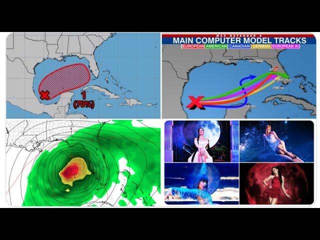
https://weather.com/storms/hurricane/news/2018-10-05-tropical-development-gulf-of-mexico-caribbean-outlook
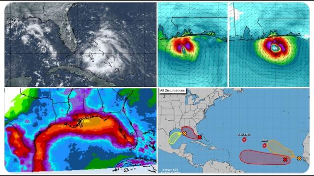
A Tropical Depression May Form By Early Next Week in the Gulf of Mexico or Western Caribbean Sea; Flood Threat For Central America
Low pressure over Central America and the western Caribbean Sea is being monitored.
A tropical depression or storm may form by next week and move into the Gulf of Mexico.
The next tropical storm would get the name Michael.
Heavy rain and flooding are threats in Mexico's Yucatan Peninsula and Central America.
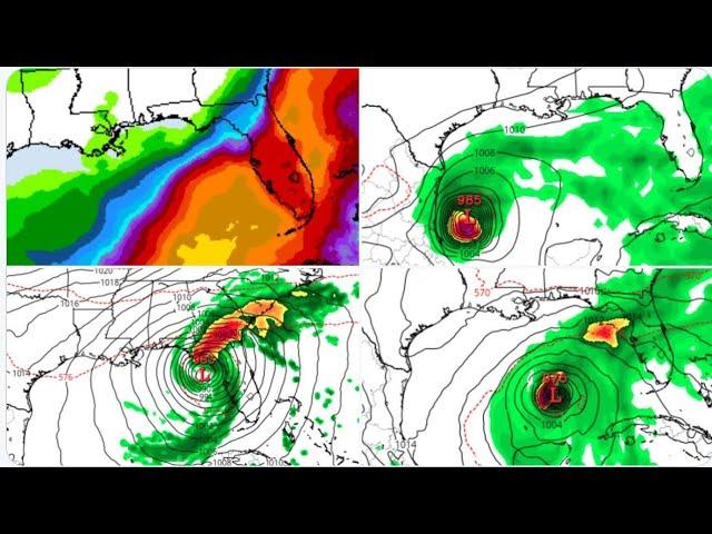
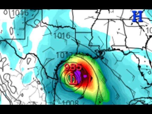
A tropical depression or storm may form by early next week in the western Caribbean Sea or Gulf of Mexico out of a large gyre of low pressure over Central America that will, regardless, trigger dangerous flash flooding over parts of Mexico and Central America.
A broad area of low pressure known as a Central American Gyre (CAG) is producing several clusters of showers and thunderstorms over Central America and the adjacent waters of the western Caribbean Sea and eastern Pacific Ocean.
These gyres most often form in late spring and early fall and can spawn tropical storms as late as November and as early as May in both the Atlantic and eastern Pacific basins. Sometimes a CAG can trigger a tropical cyclone in each basin at the same time.
45 people are talking about this
Twitter Ads info and privacy
One year ago, Hurricane Nate was spawned out of a CAG, making landfall along the northern Gulf Coast.
Does this mean history will repeat itself?
Outlook
Roughly 50 percent of Central American gyres have a tropical cyclone associated with them, according to Dr. Philippe Papin, atmospheric scientist at the U.S. Naval Research Laboratory. "When a tropical cyclone does occur, it tends to form on the northeastern side of the [gyre] and rotates counterclockwise around the larger circulation," Papin told weather.com in late September 2017.
In the short term, there is one factor inhibiting development.
A ribbon of strong westerly winds aloft is over the western Caribbean Sea, providing wind shear - the change in wind speed and/or direction with height - that is hostile to developing and active tropical cyclones.
This wind shear over the western Caribbean Sea is notably stronger than one year ago when Nate formed.
However, by early next week, this ribbon of wind shear may lift north, which could make the atmosphere more conducive for a small area of low pressure on the east or northeast side of the CAG to develop.
The National Hurricane Center currently has assigned a medium risk of tropical development early next week to this area of the Caribbean Sea or southern Gulf of Mexico.
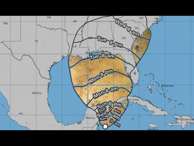
This disturbance is expected to drift northwestward toward Mexico's Yucatan Peninsula, then into the Gulf of Mexico over the next few days.
The majority of our forecast guidance at this time then suggests whatever forms, either just a tropical disturbance with a surge of moisture, tropical depression, or perhaps a tropical storm, would then be drawn northward and could eventually be a threat to parts of the U.S. Gulf Coast next week.
If this disturbance is able to organize and strengthen into a tropical storm, it would receive the name Michael.
For now, interests along the U.S. Gulf Coast should simply monitor the progress of this disturbance.
Regardless of development, this Central American Gyre will bring torrential rainfall to portions of Central America and the Yucatan Peninsula over the next few days, a feature common to most all CAGs.
These downpours could contribute to potentially dangerous and destructive flash flooding and mudslides.
Recent Notable Gyre-Induced Tropical Storms, Hurricanes
As mentioned above, Hurricane Nate was generated from a CAG one year ago.
Nate was retired from future use as a hurricane name primarily due to catastrophic flooding in Central America as Nate was forming. Thousands of homes were damaged or destroyed, and both agriculture and transportation infrastructure was significantly damaged.
Another recent example of gyre-induced tropical cyclone formation occurred in 2010 when Tropical Storm Nicole formed just south of Cuba from the gyre in late September.