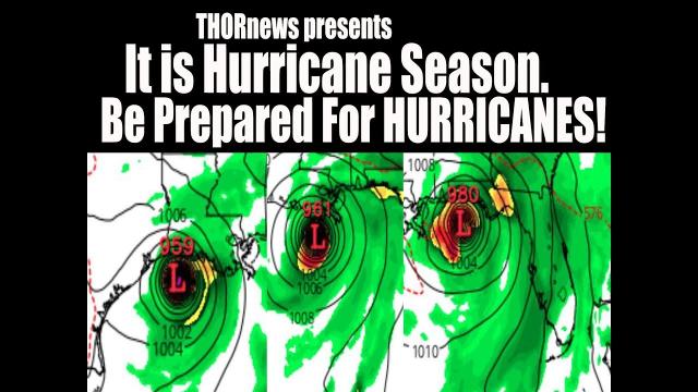
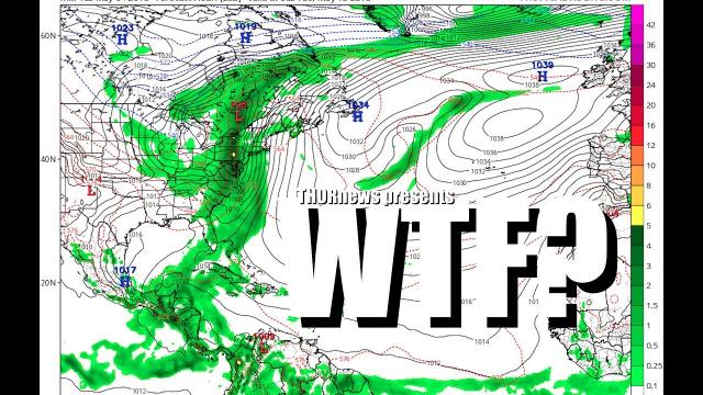
Wake Up America! The Weather is wilder than you realize! Gordon + Hurricanes
Description
Gulf Coast. We've got a lot of flooding. Hawaii. You've got a lot of moisture headed your way. And the future of hurricanes is unknown but signs point to dangerous and many. Jebi is causing a major disaster in Japan. Don't be scared. Have a plan. Be prepared. Work together. Stay Cool. God bless everyone - T
https://www.paypal.me/THORnews
Tshirts
https://hitthebuttonbaby.com/
THORNEWS
PO BOX 35946
HOUSTON TEXAS
77235-5946
the crankywxguy blog
http://www.stormhamster.com/entry/e090418.htm
the wave master
https://dabuh.com/
https://www.accuweather.com/en/weather-news/florida-us-gulf-coast-on-alert-for-budding-tropical-depression/70005956
Tropical Storm Gordon to strike US Gulf coast at near hurricane strength Tuesday evening
Gordon, currently a strong tropical storm, may make landfall as a Category 1 hurricane over the central Gulf coast Tuesday evening.
The storm made landfall over the southern tip of the Florida Peninsula on Monday.
"Gordon made a first landfall near Flamingo, Florida, shortly after 9 a.m. EDT Monday," according to AccuWeather Senior Meteorologist Rob Miller.
"As a result, Gordon is likely to make two landfalls in the United States this week," Miller said.
Gordon is moving quickly along and is expected to make a second landfall, perhaps as a Category 1 hurricane, along the corridor from Louisiana to Mississippi during late Tuesday or Tuesday night.
Louisiana Gov. John Bel Edwards declared a state of emergency Monday afternoon ahead of the storm's expected arrival in southeast Louisiana.
A voluntary evacuation has been ordered in Grand Isle, Louisiana, Mayor David Camardelle announced on the town's Facebook page on Monday.
Expect surf and sea conditions to build to dangerous levels over the northeastern and north-central Gulf of Mexico and adjacent shoreline on Tuesday. Bathers should use caution throughout the Gulf coast for occasional large waves and occasionally strong rip currents into midweek.
Strong wind gusts, battering waves, above-normal tides, minor coastal flooding, flash flooding and a couple of isolated tornadoes and waterspouts will be concerns in coastal areas from the upper Florida Gulf coast to the Louisiana Mississippi Delta region into Tuesday night.
Sporadic power outages are likely and a few trees may be downed as the storm makes landfall near the Mississippi, Alabama and Louisiana borders during Tuesday evening and moves inland to the northwest across southern Mississippi and northern and eastern Louisiana during Tuesday night and Wednesday.
Since Gordon is likely to make landfall around the time of low tide Tuesday evening, a storm surge of 2 feet with the potential for a local surge up to 4 feet is most likely. Expect some low-lying coastal roads that typically take on water during above-normal tides to be flooded.
However, the risk of wind damage and flooding would increase if significant strengthening occurs.
By the time of landfall late Tuesday or Tuesday night, Gordon may reach Category 1 hurricane strength.
Flooding to be greatest risk from Gordon
People should not let their guard down even if Gordon does not reach hurricane strength and remains a tropical storm at landfall.
Anyone living or traveling through New Orleans, Biloxi, Mississippi, and Mobile, Alabama, should prepare for potential travel delays and disruptive flooding around the middle part of the week related to direct impacts from Gordon.
Flash flooding is likely to pose the greatest risk to lives and property from the central Gulf Coast to the lower Mississippi Valley. Download the free AccuWeather app to stay aware of flooding dangers in your area and receive the latest tropical alerts.
Four to 8 inches of rain can fall from the western Florida Panhandle through southern Alabama and into Mississippi. There is the potential for an AccuWeather Local StormMax™ of 12 inches over the central Gulf coast.
This rainfall will lead to flooding and possibly even some washouts of roadways, according to AccuWeather Hurricane Expert Dan Kottlowski.
The storm may eventually join up with a non-tropical system across the northern tier of the country and enhance flooding downpours in the nation's midsection.
"This merge would not occur until late in the week and this weekend, but could bring a renewed threat of flooding in parts of the central Plains and Midwest," Sosnowski said.
Meanwhile, Tropical Storm Florence has moved well away from the Cabo Verde Islands and was spinning over the central Atlantic this week. Florence has to be watched in the long-term as the storm may strengthen significantly and could wander close to the coast of the eastern U.S. next week.