USA HURRICANE MADNESS: 4 Tropical Waves to Watch in Atlantic & 4 in the Pacific
Description
It's about to get lit. I am VERY concerned about Hawaii. Also, almost sure trouble for Florida & Possible Texas. This situation should be monitored and if you live on the Coast. Check in every 12 hours with your Weather Updates. Plan. Prepare. Now. Please.
God bless everyone,
Stay cool.
T
https://www.paypal.me/THORnews
Tshirts
https://hitthebuttonbaby.com/
THORNEWS
PO BOX 35946
HOUSTON TEXAS
77235-5946
the crankywxguy blog
http://www.stormhamster.com/entry/e083018.htm
the wave master
https://dabuh.com/
https://weather.com/storms/hurricane/news/2018-08-29-tropical-development-possible-gulf-of-mexico-florida-bahamas
Tropical Development is Possible Labor Day Weekend Near the Bahamas or Florida Next Week; Likelier Storm Development Closer to Africa.
There is a chance of tropical development Labor Day weekend closer to home.
This system may develop in the Gulf of Mexico next week.
The tropical wave that may develop is currently near the Lesser Antilles.
Another tropical wave will likely develop late this week in the far eastern Atlantic Ocean.
September is the peak month for Atlantic hurricanes and tropical storms.
A tropical wave will enhance shower activity by late this Labor Day weekend near the Bahamas or Florida. The wave has a low chance of development as it moves into the Gulf of Mexico next week, just one thing we're watching as the Atlantic hurricane season wakes up from its August slumber.
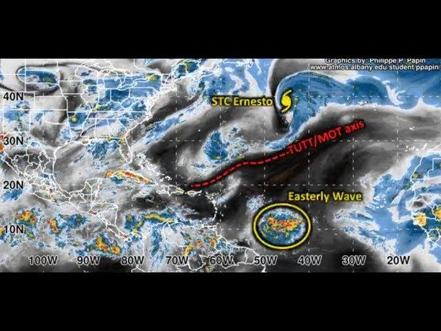
The tropical wave – essentially, an area of low pressure without a closed circulation – is currently gliding west-northwest through the Lesser Antilles, producing showers and storms.
Currently, wind shear – the change in wind direction and/or speed with height – is sufficiently low to allow this tropical wave to develop slowly over the next few days.
However, once the tropical wave reaches the Bahamas or the northern Greater Antilles
Steered by high pressure aloft parked over the eastern United States, this system may then move into the Gulf of Mexico next week.
There are some uncertainties in the suite of numerical forecast guidance, including how much land this tropical wave will interact with and how much wind shear may be in place over the Gulf of Mexico
However, a factor favoring development is the warm water in the Gulf of Mexico, with sea-surface temperatures above average and ample heat content. If a system can get into the Gulf of Mexico, it will have a better than usual chance of development.
holiday weekend plans
Bahamas, Florida, and possibly along the northern Gulf Coast Sunday into Labor Day, even if the system doesn't develop, something to keep in mind if you have holiday weekend plans in these areas.
The numerical models that do develop a tropical system move it inland relatively quickly, instead of stalling over the warm Gulf of Mexico water or near the Gulf Coast.
That would put a cap on its potential to intensify. But, again, this is all highly uncertain this far out in time.
Now is a good time to either develop or refresh your hurricane plan.
East Atlantic Wave to Watch
Multiple tropical waves are forecast to emerge off the coast of western Africa, potentially spinning up into tropical cyclones as they track westward across the tropical Atlantic Ocean, known as the Main Development Region MDR
Often referred to as African easterly waves, tropical waves are batches of energy and general spin in the atmosphere that develop due to temperature contrasts in northern Africa. The frequency and intensity of these waves
The National Hurricane Center said Wednesdatropical wave moving off the African coast by early Friday will likely develop in the eastern Atlantic by this weekend.
The system will near the Cabo Verde Islands late this week into this weekend as the tropical wave moves westward. The archipelago of more than 500,000 people will receive gusty winds and occasionally heavy rainfall.
This system will move into the open Atlantic Ocean into next week. The majority of forecast model guidance suggests it may curve northward into the central Atlantic Ocean, and not pose a land threat, but that is not a certainty at this point.
The system could be potentially strong as it moves away from the Cabo Verde Islands.
Following the tropical wave's interaction with the Cabo Verde Islands United States or the Caribbean.
"Medium-range models are indicating an uptick in activity over the Atlantic's Main Development Region in the coming 10 to 15-plus days, "Many forecasters are seeing numerous strong low-pressure systems, associated with the model's prediction of an uptick in African easterly waves pushing off western Africa, across the MDR towards the end of the European model's ensemble runs."
One of the reasons for this potential uptick in activity is that the Madden-Julian Oscillation MJO