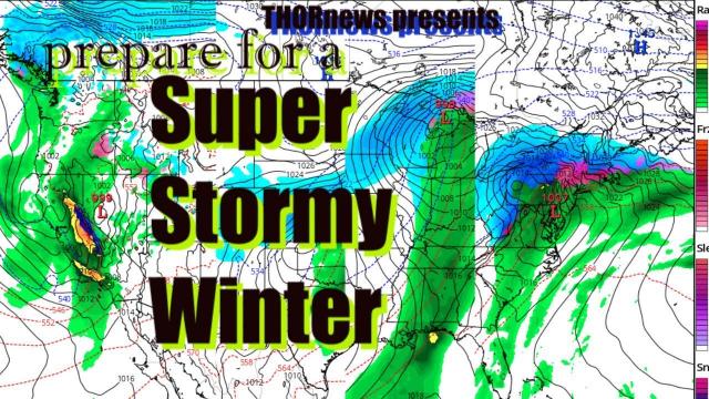
The INSTANT FREEZE has Begun! N. EAST COAST prepare for a rough 2 weeks.
Description
A form of the "worst case scenario" I laid out appears to be possible, probable or happening right now.
God Bless everyone,
T
https://www.paypal.me/THORnews
@newTHOR on twitter
https://www.facebook.com/thornewsgo
Tshirts
https://hitthebuttonbaby.com/
the crankywxguy blog
http://www.stormhamster.com/entry/e010319.htm
mike's weather page
http://www.spaghettimodels.com/
models
https://www.tropicaltidbits.com/analysis/models/
a look at the Sun
https://sdo.gsfc.nasa.gov/data/
https://weather.com/storms/winter/news/2019-01-15-winter-storm-harper-snow-forecast-plains-midwest-northeast
Winter Storm Harper Will Intensify as it Heads Into the Northeast Sunday With Heavy Snow, Sleet and Ice
A significant winter storm will hammer parts of the Midwest and East this weekend.
Heavy snow and whiteout conditions are possible Saturday in parts of the Midwest.
The heaviest snow is likely in parts of the Northeast Sunday.
Ice accumulation and power outages are also concerns.
Moderate coastal flooding is possible on the Massachusetts coast.
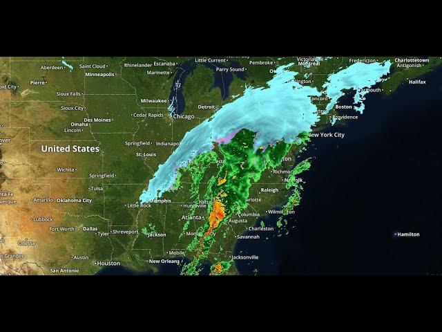
Winter Storm Harper will spread its mess of snow, ice and wind across parts of the Midwest and into Northeast this weekend after already pummeling parts of the West and Plains.
This storm is tapping into cold air as it moves through the central and eastern states through this weekend, delivering a widespread swath of significant snow.
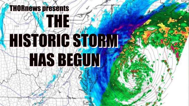
Happening Now
Snow is falling in portions of the eastern Great Lakes and interior Northeast, as of mid-evening Saturday. Moderate to heavy snow is falling from northern Ohio into much of Pennsylvania.
Areas of white out snow are occurring in northern Ohio and southern Illinois. Parts of southeastern Missouri has had 8 plus inches of snow so far.
At least a foot of snow fell Friday into Saturday in southeastern South Dakota, southern Minnesota and eastern Wisconsin, including a report of 15 inches near Heron Lake, Minnesota.
The southern warmer side produced strong to severe thunderstorms from eastern Louisiana to southern Alabama, including at least one strong tornado near Wetumpka, Alabama, on Saturday.
Winds are increasing behind the center of low pressure and snowfall rates remain high in parts of the lower Midwest, including into Ohio where 4-8 inches of snow has fallen so far. White out conditions are possible this evening.
Strong winds in parts of the Plains and Midwest are causing reduced visibilities due to blowing and drifting of snow, even in areas where it is no longer snowing.
Saturday Evening
A large area of snow, heavy in some areas, is expected from the southern Great Lakes, into the interior Northeast, with snow arriving in New England mainly late Saturday.
Strong winds may accompany the snow in the Midwest and interior Northeast, potentially leading to white out in some areas.
A band of sleet and freezing rain is possible from middle Tennessee northeastward into Ohio and eastward to the lower Hudson Valley and southern New England.
Precipitation will change to rain along at least parts of the Interstate 95 corridor overnight from New York to Boston.
Sunday
Snow is expected over the interior Northeast from parts of New York state north of the middle Hudson Valley to parts of New England.
Snow is also expected in parts of the Appalachians from eastern Tennessee through western Pennsylvania.
This snow will linger in portions of northern New England Sunday night.
Strong winds will buffet much of the East, leading to areas of blowing and drifting snow.
Some minor to moderate coastal flooding is possible along the New England and Long Island coasts, mainly during high tide on Sunday morning.
Some sleet and/or freezing rain is likely in coastal and southern New England.
New York City is likely to see mostly rain, which could be heavy at times.
Boston will switch from snow to rain in the overnight hours into early Sunday as temperatures temporarily warm up.
A flash freeze is a growing concern from Boston to New York in areas that get above freezing early Sunday. Temperatures will plummet through the day, freezing any rain or sleet that is on the ground at the time.
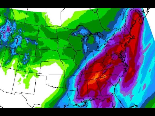
Snowfall:
A swath from the lower Midwest to the interior Northeast and New England is likely to pick up heavy snowfall.
Parts of upstate New York and New England are likely to pick up 1-3 feet of snow.
Snowfall amounts along the immediate Interstate 95 corridor, especially from southern New England through the New York City tri-state area are expected to be lower due to a change to sleet, freezing rain and rain. However, there remains some uncertainty on how quickly the changeover to rain occurs, if that occurs, and how long snow persists on Harper's back edge.
The amounts shown, particularly from southeastern Massachusetts to central New Jersey, may not match what you