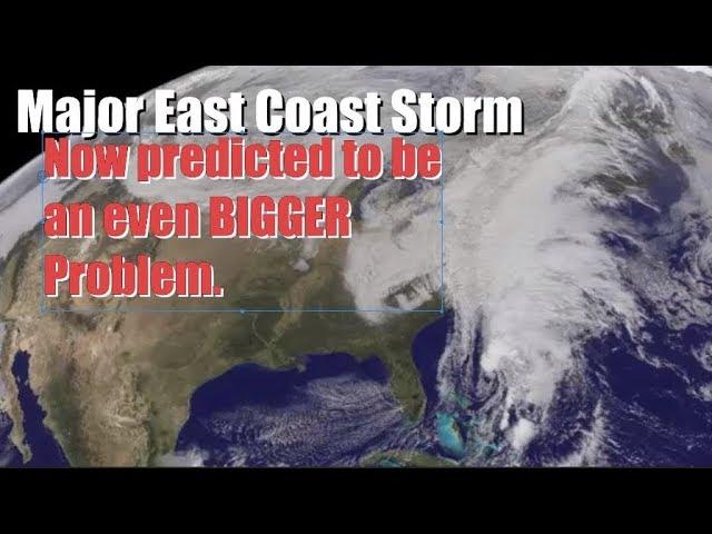
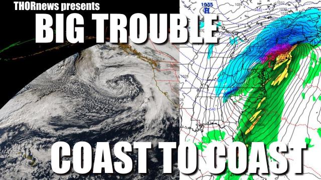
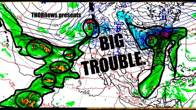
RED ALERT! This Bizarre VOODOO* Storm threatens Florida & the East Coast! THIS IS DANGER
Description
There is a strange magic wand of water pouring out of the Port of New Orleans towards Florida and up the East Coast. This major rain event is going to last for 3 weeks. Until that Wand thing stops everyone needs to monitor this situation,
God bless everyone,
T
T
https://www.paypal.me/THORnews
Tshirts
https://hitthebuttonbaby.com/
THORNEWS
PO BOX 35946
HOUSTON TEXAS
77235-5946
the excellent cranywxguy blog
http://www.stormhamster.com/entry/e072218b.htm
The Surf Master
http://www.dabuh.com
data site
http://www.spaghettimodels.com/
flood article
https://www.accuweather.com/en/weather-news/rounds-of-rainfall-to-escalate-flood-concerns-in-eastern-us-this-week/70005562
Rounds of rainfall to escalate flood concerns in eastern US this week
This past weekend's rainstorm was only the start of an abnormally wet pattern that will elevate the flood risk in the eastern United States into the end of the month.
The rainstorm drenched northern Virginia and Maryland with 3-7 inches of rain on Saturday and Saturday night, which triggered flash flooding, stranded vehicles and prompted water rescues and road closures.
Baltimore smashed a 131-year-old rainfall record on July 21 as 4.79 inches fell. The previous record from 1887 was 2.76 inches.
In the days following this rainstorm, residents should not expect a return of the dry weather that graced the region during the second half of last week.
“A cycle of daily rounds of showers and thunderstorms is likely to repeat on most days this week,” AccuWeather Meteorologist Kyle Elliott said.
A stream of moisture from the tropical regions of the Atlantic Ocean will be directed at the East Coast for much of the week, leading to days of downpours, travel delays and ruined outdoor plans.
Rainfall amounts are likely to run well above normal during this time frame, according to Elliott.
On average, most areas in the Northeast pick up 3-4 inches of rainfall during the month of July. However, some places in the mid-Atlantic have already received two times these amounts during the first three weeks of the month.
"The pattern this week can lead to additional localized totals of 5-10 inches somewhere in the corridor between the central Appalachian Mountains to the coasts of the mid-Atlantic and North Carolina," AccuWeather Senior Meteorologist Kristina Pydynowski said.
"Amounts on the upper end of that range are most likely along the eastern slopes of the mountains," she said.
Further rainfall will struggle to soak into ground that is already saturated, heightening the risk of flash flooding, rising streams and rivers that can overflow their banks and road washouts and closures.
“The pattern may escalate into a serious flood threat for some communities this week,” AccuWeather Senior Meteorologist Alex Sosnowski said.
In addition to flooding, mudslides can be triggered in the mountains. People with plans to camp or hike along the mountain range will need to keep close tabs on the weather situation this week.
There is also a risk of tree damage as a few of the thunderstorms can produce strong winds. Trees sitting in extremely wet soil can topple more easily than when it is drier.
Motorists may face slower travel times on the roadways as a result of the downpours.
Airline passengers traveling into and out of the major East Coast hubs should be prepared to face an uptick in weather-related delays.
Despite the setbacks, the pattern may completely wipe out the pockets of abnormally dry to moderate drought conditions from the Carolinas to New England.
“While the pattern may not bring rain every day everywhere, people may get frustrated by the frequency of showers and thunderstorms as far as outdoor plans, sporting events and construction projects are concerned,” Sosnowski said.
After a damp start to the week, a wedge of dry air set to overtake eastern New England on Tuesday and Wednesday is expected to keep the region drier than most locations in the Northeast.
Downpours will take aim farther west from the Carolinas to New York state on these days.
Late in the week, enough dry air may envelop the aforementioned corridor to limit the amount of downpours compared to days earlier in the week, while also pushing the heaviest rain into New England.
AccuWeather Lead Long-Range Meteorologist Paul Pastelok expects the wetter-than-normal pattern to continue for much of the East right into the start of August.
The unfolding wet pattern may not only cause more daily rainfall records to fall, but this month can end as one of the top 10 wettest Julys on record in some communities. This includes Washington, D.C., and Baltimore.