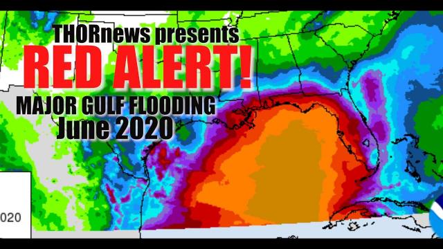
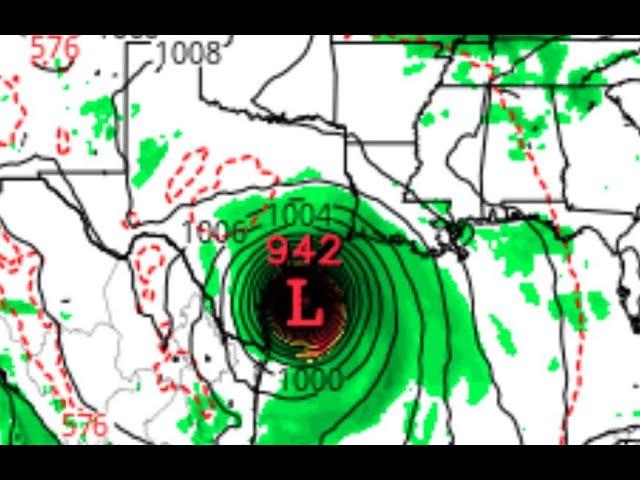
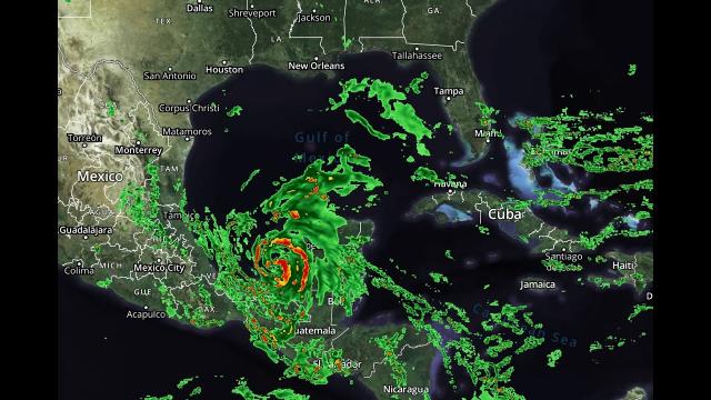
RED ALERT! Cristobal will be Hurricane Strength with a Predator Shape at landfall! Major Floods!
Description
WARNING: the eclipse energy is strong and has me tilted.
God bless everyone,
T LEWISON
5430 BIRDWOOD RD. #416
HOUSTON TEXAS 77096
https://www.paypal.me/THORnews
https://venmo.com/TEric-Lewison
$THORnews on CashApp
https://www.patreon.com/thornews
video
https://weather.com/storms/hurricane/news/2020-06-05-tropical-storm-cristobal-depression-gulf-coast-weekend-forecast
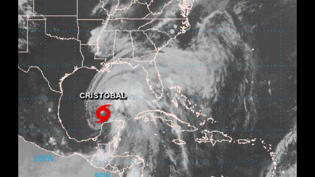
Cristobal Regains Tropical Storm Strength as It Heads for Gulf Coast
Tropical Storm Cristobal is finally moving faster over eastern Mexico.
It will emerge into the Gulf of Mexico tonight.
It will then head toward a northern Gulf Coast landfall as a tropical storm by later Sunday.
Tropical storm and storm surge watches have been issued.
Cristobal's impacts should begin to reach the Gulf Coast on Saturday.
Rain, wind and coastal flooding may linger into Monday along the northern Gulf Coast.
Cristobal's remnants are expected to move north into the upper Midwest next week.
Locally heavy rain will continue to trigger life-threatening flooding and mudslides in Mexico and Central America.
Tropical Storm Cristobal is still moving over Mexico but will track toward the Gulf Coast of the United States this weekend with expansive threats of flooding rain, coastal flooding, high surf and strong winds.
The National Hurricane Center has issued a tropical storm watch for parts of the northern Gulf Coast from Intracoastal City, Louisiana, to the Alabama/Florida border, including Lake Pontchartrain and Lake Maurepas. This means tropical storm-force winds (sustained winds of at least 39 mph) are possible in the area within the next 48 hours.
A tropical storm warning is in effect for parts of Mexico's Yucatan Peninsula, including Cancún and Cozumel. Tropical storm conditions are expected in parts of the warning area over the next few hours.
NHC has issued a storm surge watch from Grand Isle, Louisiana, to Ocean Springs, Missisippi, including Lake Borgne. This means potentially life-threatening inundation from rising water moving inland from the coast is possible within the next 48 hours.
Further to the east, a storm surge watch is also in effect from Indian Pass to Arepika, Florida, as some of Cristobal's impacts will extend well east of its center.
Cristobal weakened to a tropical depression Thursday morning but restrengthened into a tropical storm on Friday afternoon. Some additional strengthening is expected after it moves out into the Gulf of Mexico later on Friday.
Cristobal has made its predicted northward turn and is now picking up a bit of forward speed over eastern Mexico's Campeche state following its landfall Wednesday morning just west of Ciudad del Carmen.
Water vapor satellite imagery also indicates a reservoir of very dry air over the western Gulf of Mexico that looks likely to be ingested by Cristobal's circulation, another negative for tropical cyclones.
Finally, Gulf of Mexico water temperatures are currently somewhat warmer than average for early June and warm enough to support tropical development but not as warm as in midsummer, and deep heat content is lacking in the western Gulf.
All these factors should keep a lid on significant intensification of this system as it nears the U.S. Gulf Coast late in the weekend. The most likely scenario is a tropical storm landfall.
Even if Cristobal doesn't attain hurricane status, that doesn't mean it won't have serious impacts.
Cristobal is expected to have a rather large wind field for a tropical storm. Furthermore, early-June storms like Cristobal tend to be lopsided, with significant impacts far from the track of the center.
In this case, with a northward-moving Cristobal in the Gulf of Mexico, this will spread significant impacts well to the east of the center. These impacts may also arrive well ahead of the center making landfall.
This is yet another case where the forecast path will not tell the whole story of impacts.
The heaviest rainbands from Cristobal should begin to arrive along parts of the Gulf Coast as soon as Saturday, particularly in the afternoon and evening.
Again, given the storm's lopsided nature, the heaviest rain and highest flood threat is expected to fall along and well to the east of its path from Louisiana to at least the Florida Panhandle, if not parts of the Florida Peninsula.
This heavy rain could persist in bands along the northern Gulf Coast into Monday, and pockets of heavy rain will also spread northward as Cristobal heads inland into Tuesday.
Parts of the lower Mississippi Valley could see up to 12 inches of rain through Tuesday, and parts of the mid-Mississippi Valley could be soaked by several inches of rain as Cristobal's remnant moves through early next week.
Storm Surge, Coastal Flood, High Surf
Cristobal's large wind field will drive high surf to the beaches of the entire Gulf Coast, but particularly along and to the east of the track from Louisiana to western Florida, generating dangerous rip currents and coastal flooding.