Major Alert! New California Hyrdothermal Vent Field, Big Storm & Rain Records shattered
Description
We have to unite. We are running out of time.
God bless everyone,
T
https://www.paypal.me/THORnews
@newTHOR on twitter
https://www.facebook.com/thornewsgo
Tshirts
https://hitthebuttonbaby.com/
the crankywxguy blog
http://www.stormhamster.com/entry/e122618.htm
mike's weather page
http://www.spaghettimodels.com/
models
https://www.tropicaltidbits.com/analysis/models/
a look at the Sun
https://sdo.gsfc.nasa.gov/data/
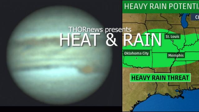
https://www.accuweather.com/en/weather-news/severe-storms-may-threaten-lives-property-from-texas-and-oklahoma-to-tennessee-and-mississippi/70006985
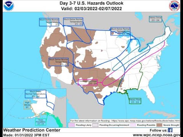
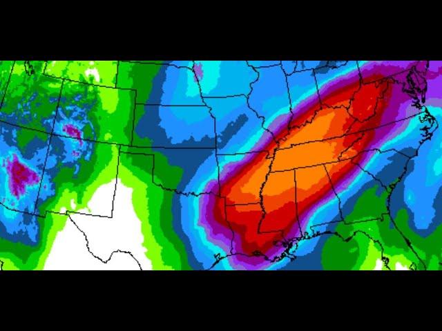
While millions of people may be focused on post-holiday activities, severe thunderstorms, including the potential for a few tornadoes, will shift eastward from Texas and Oklahoma to Louisiana, Arkansas, Mississippi and western Tennessee prior to the end of this week.
A storm will grow in size and strength over the central United States into Thursday. The storm is forecast to produce heavy snow and whiteout conditions on its northern and western flank and flooding rain on its southern and eastern flank.
Where the air becomes warm and humid enough, locally drenching thunderstorms will spring up and turn severe over part of the Deep South.
The full spectrum of severe weather is anticipated with these storms. Everything from frequent lightning strikes to flooding downpours, hail, strong wind gusts and isolated tornadoes may occur with this setup into Thursday afternoon.
This is a situation where people should monitor the weather for changing conditions in their area. This is not only for the potential approach of a severe thunderstorm or tornado, but also for when the threat of severe weather has passed.
Download the free AccuWeather app to check the latest forecast and receive severe weather bulletins for your location.
Drenching thunderstorms with small hail can occur as far north as central Kansas and southwestern Missouri on Wednesday.
However, the most violent storms are likely to occur farther south.
The first powerful storms are likely to erupt from west-central Texas to central Oklahoma late Wednesday afternoon.
Isolated severe storms may also occur farther to the east in eastern Oklahoma and northeastern and coastal Texas Wednesday evening.
The threat for isolated tornadoes is likely to occur mainly during the nighttime hours or during twilight, which may add to the danger.
Airline passengers should anticipate delays as storms approach the Dallas metro area during Wednesday evening. Other major cities that may be affected early Wednesday evening include Oklahoma City.
The storms are likely to organize into a solid or broken line that marches eastward and reaches parts of western Arkansas to central and northeastern Texas during Wednesday night.
The severe weather threat may peak in Houston, Shreveport, Louisiana, and Little Rock, Arkansas, until late Wednesday night or during the morning rush hour on Thursday. Motorists and airline passengers should anticipate delays on the roads and airports.