Houston & SE Texas under Tornado Watch until 4am & Puerto Rico Earthquakes persist
Description
God bless everyone.
T LEWISON
5430 BIRDWOOD RD. #416
HOUSTON TEXAS 77096
WWW.PAYPAL.ME/THORNEWS
www.venmo.com/TEric-Lewison
$THORnews on CashApp
https://www.patreon.com/thornews
ty susan nancy
check out the crankywxguy blog
http://www.stormhamster.com/entry2/e010920.htm
video
https://weather.com/forecast/regional/news/2020-01-06-severe-thunderstorms-tornadoes-flood-threats-south
Severe Weather Outbreak, Including Tornadoes, Likely in the South Friday and Saturday
An outbreak of severe thunderstorms, including damaging winds and tornadoes, is likely to spread across much of the South Friday into Saturday.
A strong disturbance in a sharp southward-plunging jet stream will pivot through the South beginning Friday. Southerly winds ahead of an advancing frontal system will tap warm and very humid air by January standards from the Gulf of Mexico and pull it into much of the South and Ohio Valley.
This setup will provide high wind shear – the change in wind speed and/or direction with height – and enough instability for severe thunderstorms.
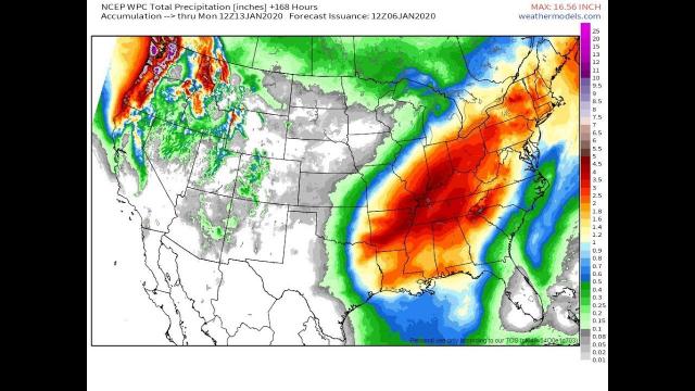
The ample moisture in play will also wring out heavy rain in some other areas that may lead to flash flooding and river flooding.
Let's step through the severe weather outlook, then discuss where the flood threat is highest.
Severe Threat Outlook
Friday
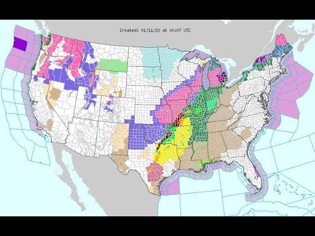
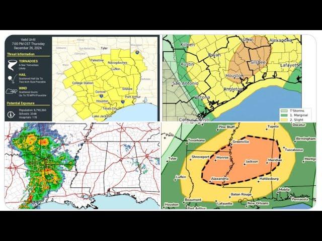
Severe thunderstorms are expected to break out by afternoon from parts of eastern Oklahoma and eastern Texas to western Arkansas and perhaps western Louisiana.
Friday night, severe thunderstorms will continue to be widespread from eastern Texas into Arkansas, southern Missouri, Louisiana and possibly into parts of western Mississippi and western Tennessee.
The severe weather threat will be from a long, advancing line of thunderstorms known as a squall line. This line of storms could have widespread damaging wind gusts and embedded tornadoes.
There might also be individual supercell thunderstorms that form ahead of the squall line, with a threat of tornadoes, large hail and damaging winds.
Saturday
Severe thunderstorms will likely continue to track through parts of the Deep South from Louisiana to Mississippi, Alabama, Tennessee, the Florida Panhandle and parts of Georgia.
This activity will likely be ongoing early Saturday morning in the form of a squall line near the western edge of the red areas depicted below, and will continue to spread farther east through much of the day.
How much severe weather lasts into Saturday evening from the Carolinas to North Florida remains somewhat uncertain.
Once again, some tornadoes are expected. Damaging thunderstorm winds should remain a significant threat as the cold front and squall line of thunderstorms accelerates.
It's also possible that there could be stronger winds spreading into parts of the mid-Atlantic and Northeast on Saturday night as an area of rain spreads through those regions.
There will also be a significant threat of flash flooding from this storm, and river flooding may last for some time after the storm is gone. For the latest forecast on this flood threat, check out our latest article here.
Check back with us at weather.com for the latest updates in the coming days on this potential severe weather and flash flood event.