High Alert! Hurricanes. River Flooding & Wild Weather USA
Description
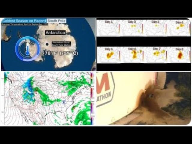
Due to all the River Flooding, Storms & Cyclonic Activity in the Oceans, I am putting y'all all on Asteroid Fight Club HIGH ALERT until October 10th, 2018. Have a Plan. Be Prepared. Don't Be Scared. Stay Cool.
God bless everyone, T.
https://www.paypal.me/THORnews
Tshirts
https://hitthebuttonbaby.com/
THORNEWS
PO BOX 35946
HOUSTON TEXAS
77235-5946
the crankywxguy blog
http://www.stormhamster.com/entry/e092618.htm
the wave master
https://dabuh.com/
https://www.surfline.com/surf-news/rosa-rapidly-intensifying-becomes-major-hurricane-swell-surf-socal-baja/35130
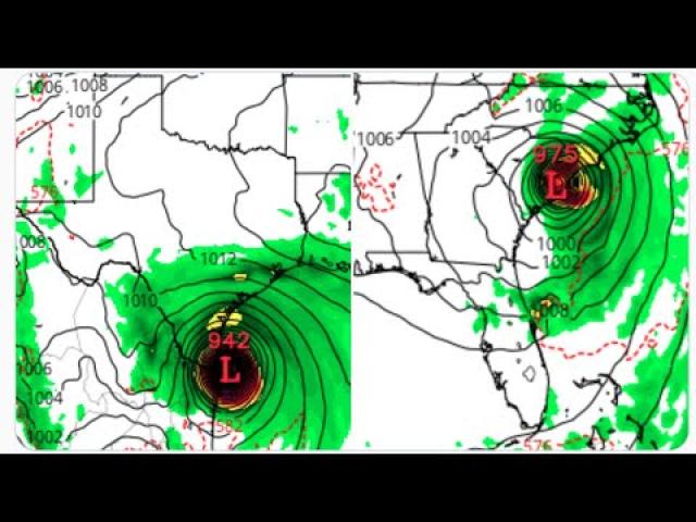
Rosa was upgraded to a hurricane with 65kt sustained winds on Wednesday morning as it undergoes a period of rapid intensification. This strengthening phase is expected to continue through the day and Rosa could become a Cat 3 hurricane by Thursday. After this period of rapid intensification, slower strengthening is expected through the rest of the week and into the first half of the weekend. As we move through the weekend, Rosa is expected to encounter unfavorable conditions and gradually weaken heading into next week.
Rosa is less than 500 miles south-southwest of the tip of Baja, moving west-northwest at nine knots. This heading continues for the rest of the week then the storm is forecast to turn more northwest by the start of the weekend, trending more northerly as we move into next week.
Read: Latest expert forecast analysis for Santa Barbara – Ventura– North LA – South LA– North OC – South OC – North SD – South SD – Northern Baja – Southern Baja
While there is some uncertainty on the longer range track of Rosa, the majority of models point to a west-northwest track during the next couple days. This would put Rosa in the SoCal swell window during the first half of today. If the cyclone tracks more northwest as expected late this week and into the weekend in response to a trough tracking toward the US West Coast, it would be an excellent track for SoCal swell production and occur while Rosa is near peak intensity.
Assuming Rosa follows forecasts and model guidance and, more importantly, trends to the very favorable NW to NNW track late this week and this weekend, Southern California/N Baja could see medium to solid SSE to S swell fill in over the weekend and into next week. Southernmost Baja should see surf a couple days prior to that.
Conditions are favorable for the hurricane to rapidly intensify, and Rosa could become a major hurricane on Thursday morning. Some additional strengthening is possible through Friday.
Gradual weakening is expected this weekend due to lower sea surface temperatures, drier air and increasing vertical wind shear.
Rosa will likely turn more toward the north this weekend in response to an upper-level trough or southward dip in the jet stream that will be approaching the southwestern United States.
Late this week and into this weekend swells from Rosa will likely cause life-threatening surf and rip current conditions to portions of the southwestern Mexican coast and southern Baja California Peninsula.
Early next week impacts to the U.S. are possible depending on Rosa's track.
Impacts Are Possible in the Southwestern U.S.
Location and strength of the upper-level trough, which is expected to amplify and push eastward into the West early next week, will play an important role in the path of Rosa.
A stronger trough would likely pull Rosa northward sooner and the center of its remnants could potentially track into the Desert Southwest on Monday or Tuesday. A weaker trough could cause Rosa to dissipate over the Pacific with fewer impacts.
Rosa will weaken as it tracks northward. There is uncertainty if it would survive that far north.
However, there are indications that at least some rain from Rosa will spread northward into the Southwest as early as Sunday. High surf and dangerous rip current conditions are also possible along the California coast beginning this weeken
In addition, the upper-level trough and cloud cover will bring cooler temperatures with high temperatures near to slightly below average for early October.
It's too soon for details on how much rain will fall or where the greatest impacts will be, so be check back to weather.com for updates.
Kirk has made a comeback as a tropical storm east of the Lesser Antilles.
Tropical storm watches and warnings have been issued.
Kirk will arrive in the Windward Islands on Thursday.
Life-threatening flash flooding and mudslides are the biggest danger.
Kirk is then expected to be ripped apart by stronger wind shear in the Caribbean Sea this weekend.
Tropical Storm Kirk has redeveloped east of the Lesser Antilles and will bring a threat of flooding rain, mudslides and some tropical-storm-force winds to parts of the Windward Islands beginning Thursday.
Tropical storm warnings have been posted for Barbados, St. Lucia, Dominica, Martinique and Guadeloupe, meaning tropical-storm-force winds (39-plus mph) are expected in these areas within 36 hours.


Comments