DEADLY Friday the 13th Blizzard & Tornado storm has begun & will last through Monday
Description
https://www.paypal.me/THORnews
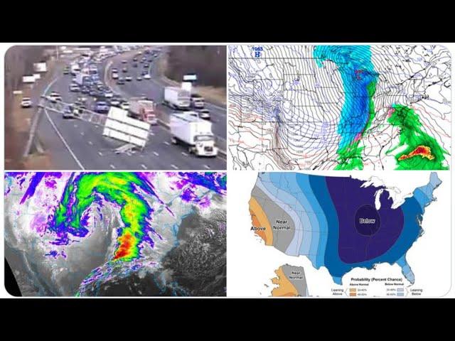
This slow moving monster which is to take place Friday April 13th-Tuesday April 17th is potentially the WORST non Hurricane storm I can remember seeing in my 5 1/2 years at THORnews.
Please be prepared & Stay Aware.
God bless everyone,
T
THORNEWS PO BOX 35946
HOUSTON TEXAS
https://www.patreon.com/thornews
@newTHOR on twitter
https://www.facebook.com/THORnewsthornews
articles on situations
https://www.accuweather.com/en/weather-news/multi-day-severe-outbreak-isolated-tornadoes-loom-across-central-southern-us/70004655
Multi-day severe outbreak, isolated tornadoes loom across central, southern US
An outbreak of severe thunderstorms, including the potential for a few tornadoes, is anticipated from portions of the central and southern Plains to the Mississippi, Ohio and Tennessee valleys spanning Friday and Saturday.
The eruption of thunderstorms will be inspired by a strong temperature contrast, fueled by daytime heating and a surge of Gulf of Mexico moisture and enhanced by strong winds and dry air aloft.
More than 22 million people will be at risk for severe weather on Friday alone. This day, the potential for damaging weather conditions will extend from near the Nebraska and Iowa border, southward to central Texas and eastward to Louisiana, Arkansas, Missouri and western Illinois.
Airline passengers should anticipate major flight delays and a high number of flight cancellations centered on the major hub of Minneapolis.
The area likely to receive between 6 and 12 inches of snow is forecast to extend from central Montana to northeastern Wyoming, much of South Dakota, southern North Dakota, northern Nebraska, much of southern Minnesota and northwestern Wisconsin.
Blizzard conditions are projected from much of Nebraska, South Dakota and southern North Dakota to central and southern Minnesota to northern Wisconsin.
The storm has the potential to bring 1 to 2 feet of snow to part of the same area that is likely to experience blizzard conditions.
Other major cities in the region likely to be adversely affected by the snowstorm include Sioux City, Iowa; Valentine, Nebraska; Rapid City, Huron and Pierre, South Dakota; Miles City, Montana; Ortonville, Minnesota; and Eau Claire, Wisconsin.
Significant turbulence is likely and may lead to issues during landing and takeoff well away from the center of the blizzard and may impact the hubs of Denver, St. Louis and Chicago.
In addition to heavy snow, blizzard conditions and severe thunderstorms, a significant buildup of ice may occur in part of Ontario, northern New Yor state and northern New England.
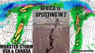
http://www.ktva.com/story/37906312/big-crack-is-evidence-that-east-africa-could-be-splitting-in-two
Big crack is evidence that East Africa could be splitting in two
(CNN) A large crack, stretching several kilometers, made a sudden appearance recently in south-western Kenya.
The tear, which continues to grow, caused part of the Nairobi-Narok highway to collapse and was accompanied by seismic activity in the area.
The Earth is an ever-changing planet, even though in some respects change might be almost unnoticeable to us. Plate tectonics is a good example of this. But every now and again something dramatic happens and leads to renewed questions about the African continent splitting in two.
The Earth's lithosphere (formed by the crust and the upper part of the mantle) is broken up into a number of tectonic plates.
These plates are not static, but move relative to each other at varying speeds, "gliding" over a viscous asthenosphere.
A severe thunderstorm and flooding rainfall are possible in Peoria, Illinois; Indianapolis; Louisville; Kentucky; Jackson, Mississippi; New Orleans; and Mobile, Alabama; on Saturday.
One area may focus near and north of the Ohio River, while a second area is likely farther south, perhaps from Tennessee to the Gulf coast.
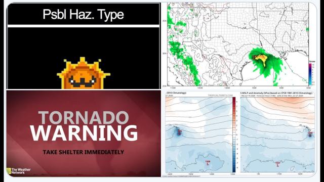
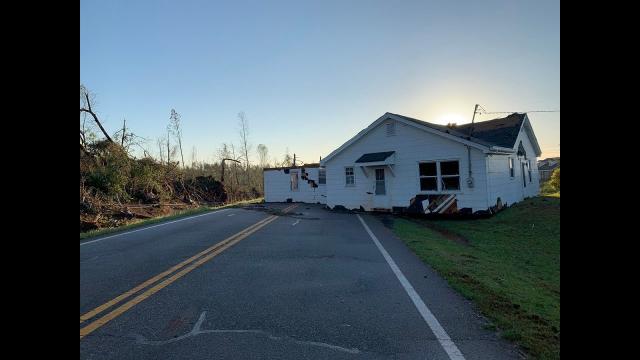
A second tornado has been reported near De Kalb, Texas, or in extreme northeast Texas near the Oklahoma and Arkansas borders.
A radar-confirmed tornado moved very near Mountainburg, Arkansas late Friday afternoon. Damage to several homes and debris in the air has been reported by local troopers. Power lines are down in the town.
Severe thunderstorms are expected across a wide area through the evening, from eastern Texas, Louisiana and Mississippi northward to eastern Oklahoma, Arkansas, western Tennessee, Missouri, eastern Kansas, Iowa and far western portions of Illinois and Kentucky.
Severe thunderstorms will likely continue in the South, possibly as a squall line. The greatest probability of severe weather appears to be in southeastern Louisiana, southern and eastern Mississippi, Alabama and the Florida Panhandle, but at least scattered severe storms are possible as far north as the Ohio Valley.
parts of Virginia to the Carolinas, Georgia and Florida.