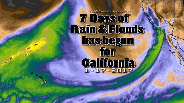
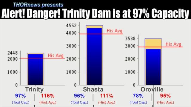
California Floods: 3 more storms in next 10 days & 2 Reservoirs over Capacity.
Description
This spring is going to be a wild and dangerous ride.
Don't be scared. Be Prepared & now is the time to work together.
God bless everyone,
T
https://www.paypal.me/THORnews
@newTHOR on twitter
https://www.facebook.com/thornewsgo
Tshirts
https://hitthebuttonbaby.com/
the crankywxguy blog
http://www.stormhamster.com/entry/e22819.htm
mike's weather page
http://www.spaghettimodels.com/
models
https://www.tropicaltidbits.com/analysis/models/
a look at the Sun
https://sdo.gsfc.nasa.gov/data/
https://www.accuweather.com/en/weather-news/next-pacific-storm-to-take-aim-at-california-this-weekend/70007573
Next Pacific storm to take aim at California this weekend
Following devastating flooding at midweek, California residents will have a short window of time to prepare for the next storm, set to arrive late on Friday.
"The first precipitation associated with the weekend storm should move onshore Friday night, with the bulk of the moisture streaming into the state on Saturday," said AccuWeather Meteorologist Kyle Elliott.
Areas recently hit hard by heavy rain and dangerous flooding can receive more rainfall this weekend. This includes places such as the San Francisco and Santa Rosa areas as well as Guerneville, which was evacuated as floodwaters overflowed from Russian River on Tuesday.
Water levels will rise again, and areas that escaped the worst impacts from flooding and mudslides earlier this week may experience them this time.
It will be important to plan ahead in order to protect property and livelihoods, and to stay up to date on local warnings and evacuation notices.
While residents of these areas should prepare for worsened flood conditions, the heaviest rain is expected to land farther south.
The highest rainfall totals are expected in the foothills of the Sierras as well as over coastal areas. Road closures are likely as flooding and mudslides make stretches of highway, including Highway 1, impassable.
Anyone on the road should drive with extreme caution, as low visibility and standing water can make driving extremely hazardous in times of heavy rain. Motorists should keep an eye out for downed trees and mudslides and never attempt to traverse a flooded roadway.
Extensive airline delays are possible as heavy rain, low visibility and gusty winds batter the region on Saturday.
Ski resort workers will need to keep their plows and shovels handy, as another round of heavy snow is also on tap with several feet of fresh accumulation possible.
Dry weather is expected to overspread the state on Saturday night, this time lasting for a few days before the next storm moves onshore next Tuesday or Wednesday.
The weekend storm will provide another fresh influx of cool air, maintaining the unusually chilly weather that has been in place in California over the past couple of weeks.
This has prevented downtown Los Angeles from reaching 70 degrees Fahrenheit in February, the first time this has happened in more than 100 years of record keeping.