Are you ready for a Wild Hurricane Season?
Description
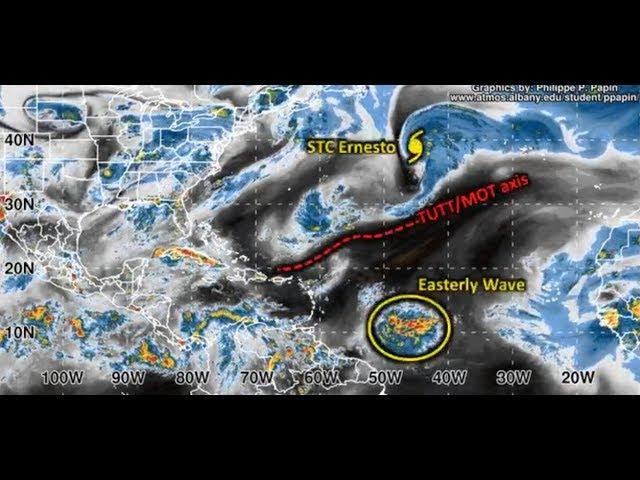
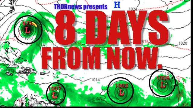
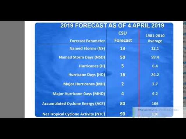
Yes. I am aware that the African dust & Wind shear are high but if those situations drop off after the August 11th Solar Eclipse, it is on like Donkey Kong & Texas & Florida & the East Coast will be in danger.
God bless everyone,
T
https://www.paypal.me/THORnews
Tshirts
https://hitthebuttonbaby.com/
THORNEWS
PO BOX 35946
HOUSTON TEXAS
77235-5946
the crankywxguy blog
http://www.stormhamster.com/entry/e080518b.htm
the wave master
https://dabuh.com/
https://weather.com/storms/hurricane/news/2018-08-01-threat-tropical-storm-hurricane-hector-hawaii
Hurricane Hector Could Pose a Threat to Hawaii This Week
Hector will likely remain a major hurricane in the Pacific Ocean to start this week.
It is still too soon to determine how close to Hawaii it will ultimately track.
A closer track could bring strong winds, heavy rain and coastal flooding to at least parts of the islands.
High surf, rip currents and at least breezy conditions are likely impacts.
Interests in Hawaii, especially the Big Island, should monitor the progress of Hector.
Hector has intensified to Category 4 status and will likely remain a major hurricane for the beginning of the week ahead, and it may pose a threat to at least part of the Hawaiian Islands by midweek.
Centered over 1,100 miles east-southeast of the Big Island of Hawaii, Hector is moving just north of due west along the southern periphery of a high-pressure system.
Hector is in an area with low vertical wind shear, which has allowed it to grow into a powerful hurricane. The increasingly drier air along Hector's future path will induce slow weakening over the next few days.
A southward plunge of the jet stream in the northern Pacific Ocean well north of Hector will weaken the aforementioned steering high enough to bend Hector a bit northward early this week.
How far north it bends is critical.
The more north Hector tracks before turning westward again, the bigger direct threat the hurricane could pose to at least parts of Hawaii by later Tuesday or Wednesday.
Having said that, it is still too soon to determine how close Hector will track to Hawaii this week, and thus, whether impacts such as damaging winds, flooding rain and coastal flooding from storm surge will affect parts of the island chain. Hawaii's Big Island has the greatest chance of seeing some direct impacts from Hector since it is located farthest south.
The Big Island could see tropical-storm-force winds (39-plus mph) by late Tuesday or early Wednesday, particularly on the southern tip of the island and eastward-facing coastlines.
Increasing swells are also likely, leading to high surf and dangerous rip currents at beaches during the middle of the week ahead, regardless of the exact track.
It is also increasingly likely that an influx of moisture will reach the islands with increasing shower activity.
Several reconnaissance flights have been scheduled into Monday to help determine the large-scale weather pattern associated with Hector's future path. This could help improve forecast guidance early this week and allow for additional details on what impacts to expect from Hector.
For now, all interests in the Hawaiian Islands, particularly the Big Island, should monitor the progress of Hector.
https://www.accuweather.com/en/weather-news/typhoon-shanshan-to-threaten-japan-later-this-week/70005681
Typhoon Shanshan to threaten Japan later in the week
Typhoon Shanshan will approach Japan later in the new week with heavy rain and high winds.
While the tropical cyclone is over the open western Pacific Ocean, it will track northwest and threaten Japan by the middle of the week.
Shanshan strengthened into a typhoon, with the equivalent strength of a Category 1 hurricane in the Atlantic and East Pacific basins, on Saturday. Shanshan will track northwest and remain over the open ocean with no direct impacts to land.
As the storm begins to approach eastern Japan early in the week, rough seas and surf will begin to reach the eastern coastline of Japan and also threaten shipping interests in the region.
Shanshan will approach the coastline of Japan by midweek causing rain and wind to move into the Greater Tokyo Area by Wednesday afternoon, local time.
This would bring significant impacts to the Japan mainland with the greatest risk for damaging winds and flooding rainfall across eastern and northern Honshu, including the Greater Tokyo Area.
The worst and most widespread impacts to land will occur from later Wednesday into Thursday.
Parts of this threat area recently endured flooding and locally damaging winds from former Typhoon Jongdari.
Another round of heavy rainfall and strong winds could result in widespread power outages and tree damage, along with an elevated risk for mudslides and transportation disruptions.


Comments