Alert! Tropical Storm Arthur to hit New Jersey New York New England! Venus Retrograde Surprise?
Description
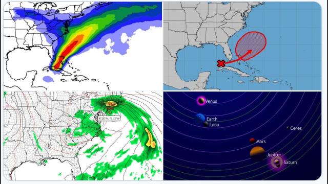
The latest GFS run has 996 mb Tropical Storm Arthur hitting New Jersey then New York then New England in 72 hours. This falls in the 7 day post Venus Retrograde window I have been discussing all year so be prepared for it to surprise us and intensify to hurricane strength.
God bless everyone,
T LEWISON
5430 BIRDWOOD RD. #416
HOUSTON TEXAS 77096
https://www.paypal.me/THORnews
https://venmo.com/TEric-Lewison
$THORnews on CashApp
https://www.patreon.com/thornews
video on storm
https://weather.com/storms/hurricane/news/2020-05-16-future-arthur-invest-90l-subtropical-tropical-florida-southeast
Tropical Storm Arthur, First of the 2020 Atlantic Hurricane Season, Likely This Weekend off Southeast Coast
The National Hurricane Center is tracking its first area for development in the Atlantic in 2020.
A tropical or subtropical storm is expected to form near or just north of the Bahamas this weekend.
Once it becomes a storm, It will be named 'Arthur'.
It is then expected to track northeast, but remain off the Southeast coast through early next week.
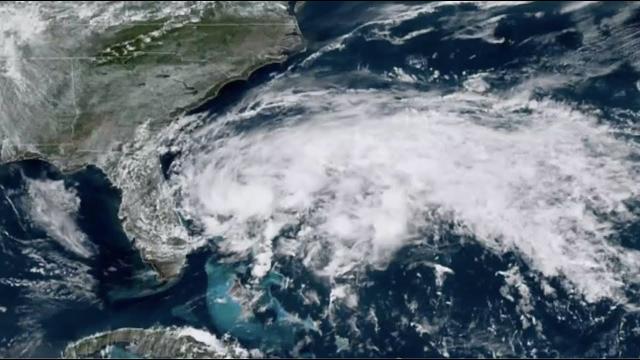
The first tropical or subtropical storm of the 2020 Atlantic hurricane season, "Arthur", is expected to form near the Bahamas this weekend, but will only bring a glancing blow of rain to parts of Florida, and high surf to parts of the Southeast coast.
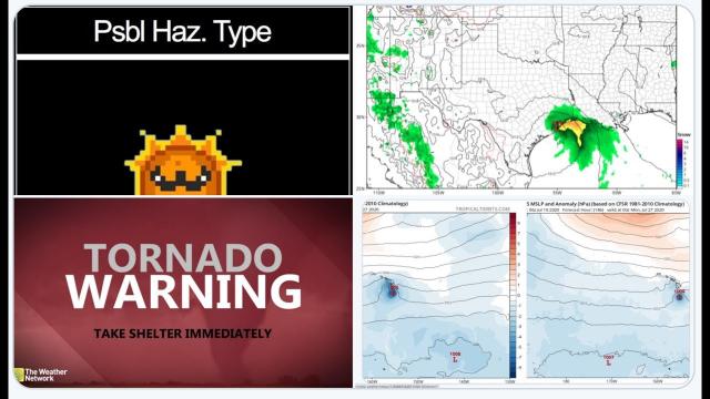
A broad area of low pressure located near the southeast coast of Florida has been producing disorganized showers and thunderstorms, along with gusty winds over parts of South Florida and the northwestern Bahamas.
Friday morning, Miami and Ft. Lauderdale took the brunt of the heaviest rain. Rain fell at the rate of almost 2 inches per hour, triggering a flash flood warning for Miami-Dade County, where street flooding was reported to be widespread, according to the National Weather Service.
Thursday, over 5 inches of rain pounded Florida's Middle Keys, a top 10 wettest day all-time in Marathon, Florida, triggering some street flooding. Wind gusts as high as 45 mph were recorded in the Lower Keys Thursday.
Wind shear, a shredding of clouds by varying winds in different layers of the atmosphere, has continued to decrease and become more favorable for slow development of this disturbance since Thursday.
These winds are expected become far more favorable Saturday.
The Hurricane Hunters are scheduled to fly into this developing system Saturday, to help figure out what is going on in the lowest levels of the atmosphere, and to discern if the system has become a tropical or subtropical depression or storm.
Invest 90L is likely to sharpen and acquire characteristics of a subtropical or tropical storm this weekend as it moves northeastward.
A subtropical depression or storm exhibits features of both tropical and non-tropical systems. This includes no cold or warm fronts, a broad wind field and at least some thunderstorms removed some distance from the center.
The National Hurricane Center issues advisories and forecasts for subtropical depressions and storms. They are assigned a number or name, just like a tropical depression or storm. This year's first named storm in the Atlantic basin would be Arthur.
Florida, Bahamas Rain, Wind, Waves
This system will gradually have less impacts over South Florida even as it develops and strengthens because thunderstorms are expected to be on the eastern side of the system, but some showers and thunderstorms are possible into this weekend.
The heaviest rain from the system is expected to fall over the Bahamas through Saturday.
The system will continue to provide gusty winds to Florida and the Bahamas this weekend.
Those gusty onshore winds will likely create dangerous rip currents and high surf along much of Florida's eastern coast. The National Weather Service in Miami is warning that there is a high risk of rip currents at South Florida beaches. This rip current threat should spread north along Florida's Atlantic beaches through the weekend as the system gains steam.
Where "It" May Track
Once the storm forms, it is then expected to move north-northeast, with its center remaining off the East Coast, trasurf and rip currents to beaches from Florida to Georgia, the Carolinas, Virginia Tidewater, and possibly farther north up the Eastern Seaboard into early next week.
There is at least a low chance that this system will be close enough to the East Coast to provide some rainfall from the Carolinas northward to southeastern New England early next week.
It could also bring some coastal flooding at high tide in some of these areas.
Check back with us at weather.com for forecast updates as these details come into focus.
Preseason Storms Have Been Common Lately
This potential development off the Southeast coast is another example of how storms can sometimes form before the hurricane season officially begins on June 1.
Since 2015, at least one named storm has developed before June 1 each hurricane season, some of which had impacts in the United States and elsewhere in the Atlantic Basin.