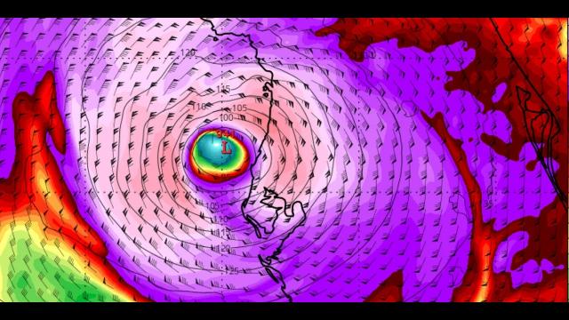
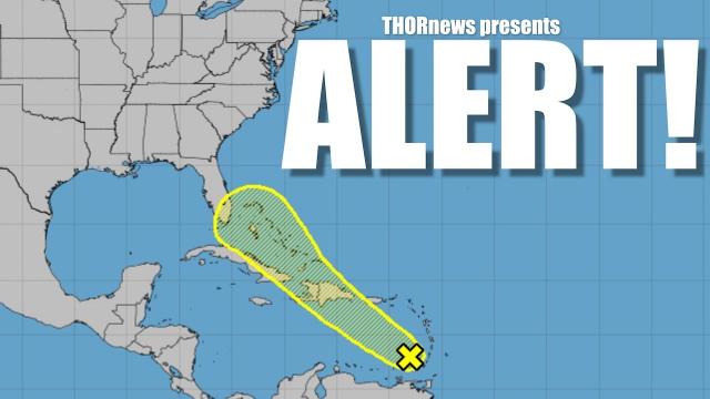
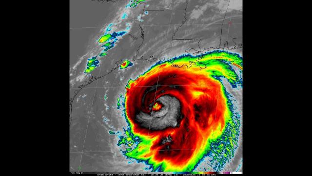
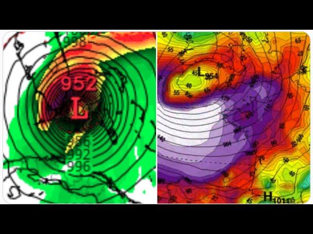
Alert! Danger! NASTY Hurricane Ahead 4 Waves to Watch + Eurocane hits London
Description
I'm not in a good mood.
God bless everyone,
T
T LEWISON
5430 BIRDWOOD RD. #416
HOUSTON TEXAS 77096
HTTPS://WWW.PAYPAL.ME/THORNEWS
the CrankyWXguy blog (Not me but recommended reading)
https://www.palmbeachpost.com/news/20190729/hurricane-season-systems-beginning-to-bubble-in-atlantic
Hurricane season: Systems ‘beginning to bubble’ in the Atlantic
The tropical wave south of Puerto Rico is not a concern, but new systems expected to launch from Africa as Phase 2 of storm season nears.
A sloppy collection of rain showers in the eastern Caribbean Sea caught the attention of National Hurricane Center forecasters this week as the tropical conveyor belt in the Atlantic basin chugs punctually to life.
The tropical wave south of Puerto Rico had just a 10 percent chance of development over five days as of 8 p.m. Monday with meteorologists unsure it would survive a clawing wind shear or the soaring peaks of Hispaniola.
A more inviting atmosphere awaits it in the Florida Straits, but early forecasts show the most South Florida could expect is higher chances of rain late this week as the disturbance skirts a path east of the state similar to the system last week.
“The impacts could be a shot of heavier rain, but if it stays east, the rain chances will be lower,” said Robert Garcia, a meteorologist with the National Weather Service in Miami. “For people who may want to boat this weekend or go over to the Bahamas, it’s something to keep an eye on.”
Forecasters are also eyeing a more robust wave that tumbled off the coast of Africa into the main incubator for peak-season cyclones — a yawning stretch of fertile Atlantic that begins east of the Cabo Verde Islands. As of 8 p.m., it had a 20 percent chance of development over the next five days.
“Right on schedule, systems are beginning to bubble in the Atlantic,” said Bob Henson, meteorologist and writer at Weather Underground, part of IBM. “In general, you expect the deep Atlantic tropics to become more active as we get into August and that’s exactly what’s happening.”
The easterly African waves that serve as embryos for Atlantic tropical cyclones move off the coast every three to five days this time of year. They form when rainfall patterns shift in Africa, sending thunderstorm systems toward a ribbon of swift winds at about 15,000 feet called the African Easterly Jet. On the south side of that stream of air, the storms begin to rotate, spinning toward the coast like pinwheels.
“We are seeing a pretty active wave train for this early,” Henson said.
The last named storm this season was Barry, which lasted just three hours at hurricane strength as it made landfall along the central Louisiana coastline on July 13. Before Barry, subtropical storm Andrea spun harmlessly for less than 24 hours in the far off Atlantic in late May.
Tropical Depression 3 tried to become Chantal last week, but fizzled before earning a name.
“It’s kind of par for the course, you expect junk in June and July, and I can’t think of anything more junky looking than Barry,” said Phil Klotzbach, a hurricane researcher with Colorado State University who will begin issuing hurricane forecasts every two weeks on Aug. 5. “Even if the next couple of weeks are quiet, it doesn’t really say that much about the season.”
At least seven hurricanes have made landfalls in Florida during July, including 2005′s Hurricane Dennis, which hit the Panhandle as a Category 3 cyclone. August counts about 19 Florida hurricane landfalls, six of which were Category 3 or higher. The strongest August storm for Florida was 1992′s Category 5 Hurricane Andrew.
Earlier this month, the Climate Prediction Center said the hurricane-destroying climate pattern El Niño will transition to neutral by the end of summer, a time when the Atlantic basin will still be in the throes of peak storm season.
“Usually a neutral forecast means neutral conditions for hurricane season, so we expect an average year all else being equal,” said Falko Judt, a research meteorologist with the National Center for Atmospheric Research.
Without a strong signal from El Nino or La Nina, more localized weather patterns can drive tropical development, Henson said.
Warmer ocean temperatures, frontal boundaries and the Madden Julian Oscillation — a large-scale area of storminess that circles the globe every 30 to 60 days. Henson notes that sea surface temperatures in the Atlantic are similar to the 2018 hurricane season where the subtropics had warmer water than the true tropics.
“We haven’t had a real noteworthy season so far,” Henson said. “Seasonal outlooks have been calling for a near-average season, but even a quiet season can produce an Andrew.”