4 Possible Hurricanes in the Atlantic = Florence 2 AND Sandy 2?
Description
this ain't no joke.
God bless everyone,
T
https://www.paypal.me/THORnews
Tshirts
https://hitthebuttonbaby.com/
THORNEWS
PO BOX 35946
HOUSTON TEXAS
77235-5946
the crankywxguy blog
http://www.stormhamster.com/entry/e092118.htm
the wave master
https://dabuh.com/
https://www.miamiherald.com/news/weather/hurricane/article218788400.html
Hurricane forecasters are watching out for four tropical systems. Again.
After a brutal start to September, when Florence and three other named storms churned across the Atlantic at once, hurricane season is simmering again.
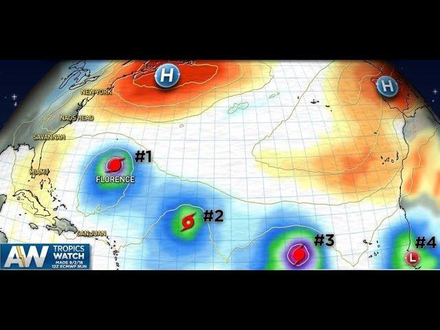
On Friday afternoon, National Hurricane Center forecasters were watching four systems with the potential to become tropical depressions or storms. The storm closest to the U.S., and headed for the Windward Islands, became better organized during the day after a messy morning and could become a tropical depression by Friday night, forecasters said in a 4:20 p.m. update.
A wave rolling off the African coast could also blossom into a tropical depression next week.
“We can’t let our guard down yet,” Senior Hurricane Specialist Mike Brennan said.
Two other systems churning to the north, including one spawned by Florence’s trailing energy, are less ominous. One closer to the U.S. coast has lower odds of becoming a storm while the second is more likely, but far from the U.S. coast.
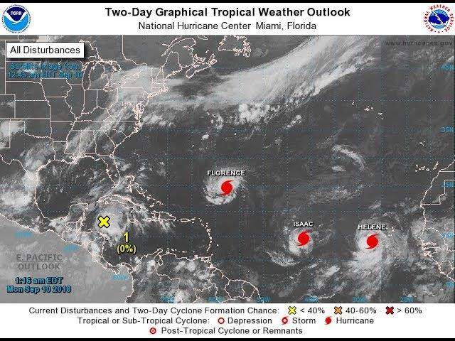
The uptick follows a brief lull after Florence made landfall last Friday morning in North Carolina, where widespread flooding from heavy rain continues, and tropical storms Helene, Isaac and Joyce swirled around the Atlantic. Gordon also made a sudden appearance, crossing the Keys as a tropical storm, but fizzled out before the others got their start.
For South Florida, the most worrisome months are still to come.
“We still have that secondary bump in activity as we get into mid-October and start to see fronts in the Gulf of Mexico and the Caribbean,“ Brennan said. “And one of the most likely times for us to be affected in South Florida is in October, when storms develop in the northwest Caribbean and then get picked up and moved to the north, northeast.”
Having four systems in the basin at once this time of year is not unusual, he said. In fact, having so many, but none as tropical depressions or storms, is more unusual.
The year was always expected to be busy. In May, the National Oceanic and Atmospheric Administration forecast an above-average season with 10 to 16 named storms and one to four major hurricanes. In August, as an El Niño weather pattern showed signs of forming over warm Pacific waters, which can generate upper levels winds in the Atlantic to help smother storms, they scaled back the number of storms to 9 to 13 named storms and two or fewer major hurricanes.
But so far, the El Niño has been a little slower to develop than expected. In August, forecasters said the system was more than likely to develop in the fall. This month, they lowered the odds to 50-50 during the fall and more likely over winter months.
The systems brewing in the Atlantic now are scattered and varied. The closest system, located 500 miles east of the Windward Islands Friday and moving west at 10 mph, organized quickly during the day, with odds for a storm bumped up from just 10 percent in the morning to 40 percent in the afternoon. However, dry air and wind shear should keep it from intensifying more by the end of the weekend.
Farther north, a system spun off Florence is also likely to face dry air and strong wind shear hampering it. Forecasters gave it just a 30 percent chance over five days on Friday afternoon. To the northeast, a system between Bermuda and the Azores has a far greater chance as it collides with more favorable conditions — forecasters put the odds at 70 percent over five days — but poses no threat to the U.S. coast.
The system to watch remains far away, about 600 miles southeast of the Cape Verde islands. However, it’s expected to slowly get better organized as it moves at a quick clip of 15 to 20 mph and could be a tropical depression by next week.
“We certainly can’t exhale here in South Florida yet,” Brennan said
Local groups start rlief drive for victims of Hurricane Florence
As North Carolina rivers swell, Florence ‘never more dangerous.’ Death toll rises to 17
I drove through the hurricane. Don’t be like me.
Isaac has ‘dissipated,’ but not done soaking the Caribbean; 2 storms remain in Atlantic
Hurricane Florence rains trigger possible coal-ash spill into lake at Wilmington plant
This recent break in tropical activity came after a busy first half of September. This was no surprise, as the active period came at the peak of hurricane season in the Atlantic.
uda and the Azores