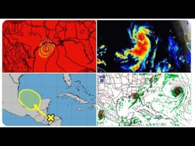
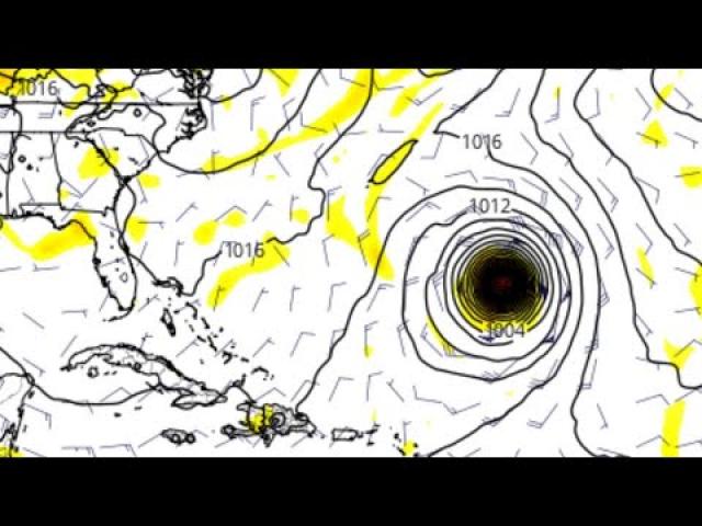
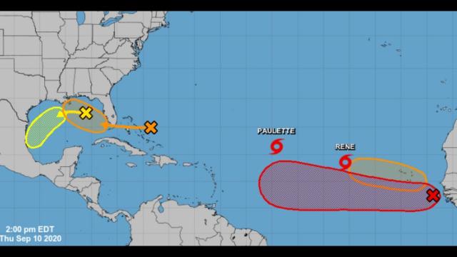
1st Landfalling Hurricane of the Season/Year?
Description
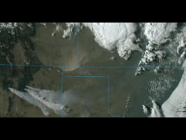
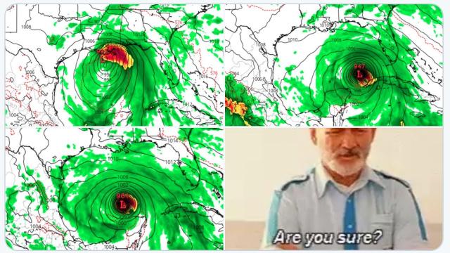
It looks like we've got MAJOR trouble on our hands in 16 days.
This one looks real. This one looks like real trouble. Gulf Coast & Atlantic Coastal states. Watch this one closely.
God bless everyone,
T
https://www.paypal.me/THORnews
THORNEWS PO BOX 35946
HOUSTON TEXAS
77235-5946
https://www.accuweather.com/en/weather-news/severe-storms-isolated-tornadoes-to-threaten-damage-in-northeastern-us/70004855
Evacuations ordered as Hawaii's Kilauea Volcano erupts; Magnitude 6.9 earthquake rocks Big Island
Severe storms, isolated tornadoes to threaten damage in northeastern US
Steam and lava were seen spewing from a crack in the earth's surface.
"Additional vents and new lava outbreaks may occur and at this time it is not possible to say where new vents may occur," the USGS said.
While many of the hundreds of small earthquakes reported earlier this week were below a magnitude of 3.0, several larger earthquakes were reported around the big island on Friday.
Shortly after 12:30 p.m. HST Friday, a magnitude 6.9 earthquake occurred on the south flank of the volcano, the USGS reported. This is the strongest earthquake to hit the island since a magnitude 7.1 quake occurred on Nov. 29, 1975.
The Pacific Tsunami Warning Center said there was no threat of a tsunami.
Damage to trees and power lines is expected to be the most widespread impact from the storms. However, there can also be hail and a few isolated tornadoes.
One thunderstorm produced a wind gust of 61 mph when it tracked over Detroit's Metropolitan Airport earlier on Friday afternoon.
More than 265,000 customers were without power across Michigan, according to PowerOutage.us. Over half of those affected are customers of DTE Energy in southeastern Michigan.
A tree toppled by high winds is being blamed for injuring a postal worker in South Lyon (located northwest of Detroit), Michigan, the Detroit Free Press reported.
Pittsburgh and Williamsport, Pennsylvania; Buffalo, Binghamton, Syracuse and Albany, New York; Burlington and Brattleboro, Vermont; Lebanon, New Hampshire; and Portland, Maine; are among the other cities that may be rocked by the violent weather.
Those out hiking, biking or taking part in other outdoor activities should keep a close eye to the sky and keep up-to-date with local severe alerts.
Enabling audible alerts on your cell phone is a great way to receive severe weather bulletins as they are issued so you can seek shelter accordingly.
Loose outdoor items should be secured or stowed away in a garage or house until the storms have passed.
Motorists along stretches of Interstates 70, 79, 80, 81, 86, 87, 90 and 91 should be prepared to face downpours heavy enough to slow travel, drastically reduce visibility and create a heightened risk of hydroplaning at highway speeds.
The risk of flash flooding will be limited to a localized level given the quick-moving nature of the overall storm system.
“The severity of the thunderstorms is expected to lessen prior to reaching the I-95 corridor from Boston southward,” said AccuWeather Senior Meteorologist Kristina Pydynowski.
There is the potential for brief delays during the early innings of the MLB games in New York City on Friday evening.
“Wind damage may not be confined to thunderstorms,” Pydynowski warned. "More prolonged gusty winds outside of thunderstorms can be strong enough to cause power outages, tree damage and flight delays. Drivers of high-profile vehicles should use caution for dangerous crosswinds."
Wind May 4
These are the expected wind gusts outside of the severe thunderstorms set to cross the Northeast.
Gusty winds in excess of 40 mph are expected to spread from the Lower Peninsula of Michigan to New York state by Friday evening. The gusty winds will then focus on New England Friday night.
As the storms exit on Friday night, it will mark the end of the record warm spell. However, residents should not get their hopes up for a dry weekend, as some wet weather will return Saturday into Sunday.


Comments