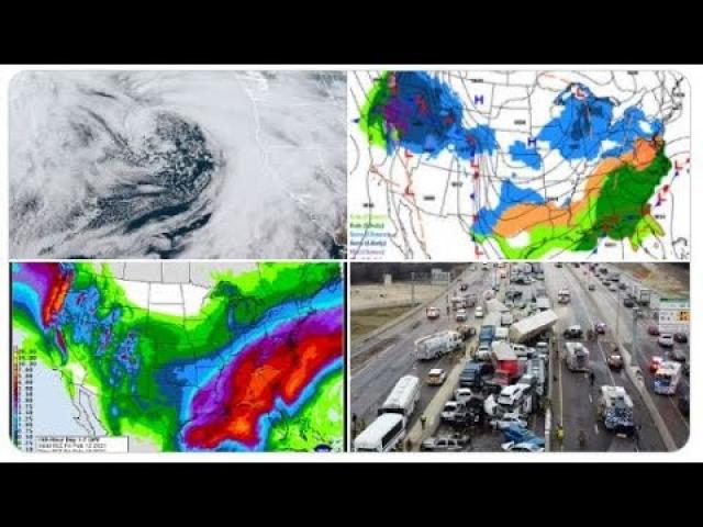
RED ALERT! Record Breaking Double Coast to Coast storms hitting USA before Thanksgiving
Description
This is the most dangerous week of weather of the year for the USA
and it might get worse through December.
God bless everyone,
T LEWISON
5430 BIRDWOOD RD. #416
HOUSTON TEXAS 77096
WWW.PAYPAL.ME/THORNEWS
www.venmo.com/TEric-Lewison
$THORnews on CashApp
https://www.patreon.com/thornews
check out the crankywxguy blog. he's a genius
http://www.stormhamster.com/entry2/e112319.htm
a video
Thanksgiving Travel Headaches Likely Across U.S.; Multiple Storms Expected From Coast to Coast
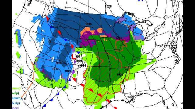
n active weather pattern is shaping up for Thanksgiving week.One system will bring snow and rain to the central U.S. Tuesday and the East Wednesday.Another system will bring a prolonged siege of rain and snow to the West starting Tuesday.The second storm bring more snow and rain to the central U.S. late this week.
Thanksgiving travel headaches are likely this week as multiple storm systems track across the country with rain, snow and wind.
More than 55 million travelers are expected to travel 50 miles or more from their homes for the holiday, according to AAA. This makes it the second-highest Thanksgiving travel volume since AAA began tracking in 2000, behind only the record set in 2005.
Here is our latest thinking on the forecast through the week ahead.
Tuesday's Outlook
One low-pressure system should be located over the Midwest, while a second system will push ashore into the West Coast Tuesday into Tuesday night.
Travel Concerns: Weather-related travel delays are likely for much of the Midwest into the lower Mississippi Valley, as well as in parts of the Rockies and from Central California to the Pacific Northwest.
Northeast: Dry conditions are anticipated during the day, with rain possibly developing Tuesday night in the interior Northeast. Highs will be warmer than average.
South: Rain and thunderstorms are possible from the lower Mississippi Valley into the Deep South. Most of the Southeast will remain dry Tuesday, with some showers developing Tuesday night. A few thunderstorms could turn severe.
Midwest: Wind-driven snow will spread from the Central Plains to the upper Mississippi Valley and northern Great Lakes Tuesday into Tuesday night. Dangerous travel conditions will exist in these areas due to low visibility and slick roads. Rain is likely from the mid-Mississippi Valley into the southern Great Lakes Tuesday and will spread into the Ohio Valley and the rest of the Great Lakes by Tuesday night.
West: Snow will continue in parts of the central Rockies, while rain, mountain snow and strong winds will increase from Central California into the Northwest. The most dangerous travel conditions, including on Interstate 5, will be in southwestern Oregon and Northern California.
Wednesday's Outlook
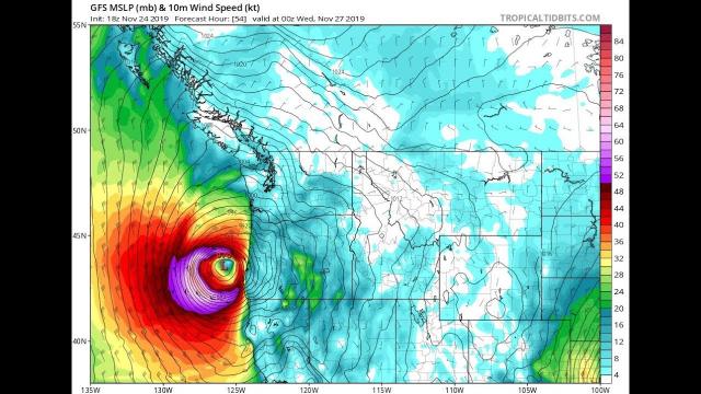
One storm system will affect the East as two other weather systems converge on the West and Southern Plains.
Travel Concerns: Scattered rain showers could dampen travel in the East. Windy conditions in the Great Lakes and Northeast might cause airport delays. Rain is expected in the lower elevations of California, as well as in the Southwest. Snow will slicken roads from the Sierra Nevada of California to the interior West.
Northeast: Rain showers and gusty winds might cause some airport delays in parts of the Northeast.
South: Rain showers will spread across the Southeast. Some air-travel delays are possible in Atlanta, particularly early in the day. A separate area of rain will impact road travel in the Southern Plains.
Midwest: Strong winds could cause airport delays in the Great Lakes region. Snow and wind will create dangerous travel conditions in the upper Mississippi Valley and northern Great Lakes. Rain showers should spread across the Ohio Valley and southern Great Lakes.
West: An expansive, cold storm should bring rain and low snow levels to California, as well as parts of the Great Basin and Rockies. Air- and road-travel delays are possible in San Francisco and Los Angeles. Dangerous driving conditions could develop as snow falls from California's Sierra Nevada into the Rockies. Snow could begin to impact travel on Interstate 5 through the Grapevine in Southern California by later in the day. There could also be snow on Interstate 15 through Cajon Pass in Southern California by Wednesday evening.
Thanksgiving Day Outlook
An expansive storm system will impact travel on Thanksgiving Day in the West and Plains.


Comments