Evacuate parts of East Coast due to MONSTER Nor'Easter Waves & Coastal Flooding
Description
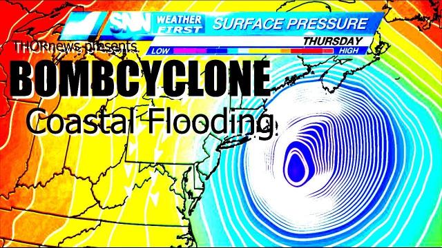
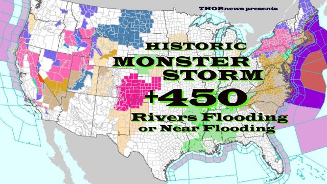
I officially recommend that parts of New Jersey & New England that are close to the Ocean shore evacuate due to Wind, Waves, Rain and Storm Surge which will cause major coastal flooding. I believe we will see historic flooding from this freak storm that is possibly catastrophic.
Please check the situation in your area and cross reference my advice with other trusted sources and use your critical thinking to make the call.
Please take this situation seriously.
God bless everyone,
T
T
https://www.paypal.me/THORnews
https://www.patreon.com/thornews
@newTHOR on twitter
https://www.facebook.com/THORnewsthornews
THORNEWS PO BOX 35946
HOUSTON TEXAS
77235-5946
article on storm
https://www.accuweather.com/en/weather-news/noreaster-to-become-bomb-cyclone-fierce-winds-flooding-snow-and-coastal-havoc-on-tap/70004298
Nor'easter to become bomb cyclone: Fierce winds, flooding, snow and coastal havoc on tap
High winds to cause widespread power outages, travel disruptions and property damage.
Flooding rainfall in store for some locations, and coastal flooding will occur.
Rain to end as snow in many areas, with risk of a foot or more of heavy, wet snow in a narrow zone.
An already potent storm will track off the Atlantic coast and become a bomb cyclone that is likely to cause high winds, coastal flooding and heavy wet snow in the northeastern United States centered on Friday.
Part of the same storm already caused significant flooding and produced severe thunderstorms over the South Central states and will bring a change to heavy wet snow and strong winds to the lower Great Lakes region on Thursday night.
The full power of the storm will be felt in the Northeast. The storm will strengthen and the pressure in the center of the storm will plummet so fast that it will likely become another bomb cyclone of the winter of 2018.
Major trouble anticipated from high winds
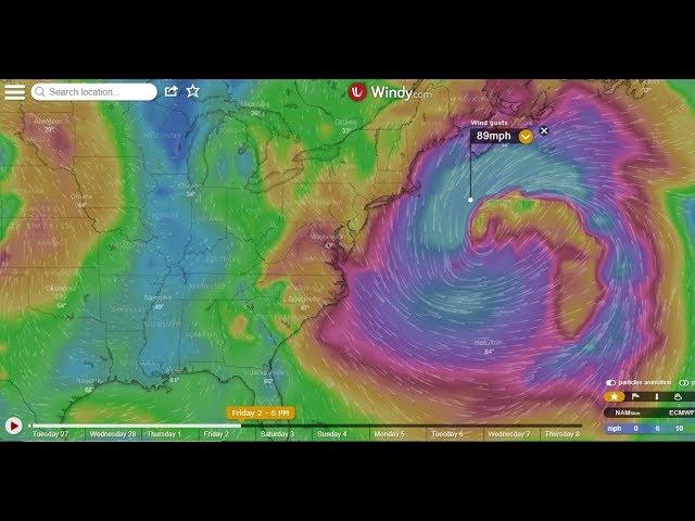
The most far-reaching effect of the storm will be high winds. Gusts of 50-60 mph will be common from the central and southern Appalachians to the lower Great Lakes and part of northern New England. However, gusts approaching hurricane force are likely along the coast from Delmarva to eastern Massachusetts. The strongest winds are likely to be along the coast of eastern Massachusetts.
Extensive power outages are likely spanning Friday to Saturday. Have a working flashlight on hand, and keep cell phones charged.
Winds as strong as predicted can knock down trees, cause damage property and make loose objects into projectiles. Walking, standing or driving through areas where there is a canopy of trees may be very dangerous during the storm.
Major airline delays and flight cancellations are likely due to the wind alone from Chicago and Detroit to Washington, D.C., Baltimore, Philadelphia, New York City and Boston. Wind-related delays are possible as far south as Charlotte, North Carolina, and Atlanta.
Airlines were waiving change fees ahead of the storm, according to the USA Today.
Most of the problems from the storm in Washington, D.C., and Baltimore will be due to the wind and not so much from rain and any brief period of snow at the end.
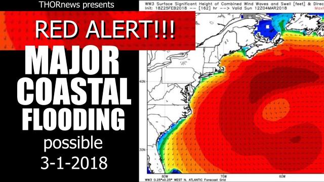
Coastal inundation may behave like a tropical storm or hurricane
Depending on the wind direction, ocean and/or bay waters will be pushed inland, and substantial coastal flooding and beach erosion are anticipated. As the storm moves along and the wind shifts, areas that were not flooded initially may take on water.
Tides are likely to run 2-4 feet above normal. Tides may be as much as 5 feet above normal at peak, where the shape of the coast acts as a funnel and prevents water from escaping.
The worse conditions are likely in eastern Massachusetts, where officials have already asked coastal residents to evacuate, according to Mass Live.
Offshore waves of 30 feet are forecast. All vessels are encouraged to remain in port. Large vessels should remain at sea until the storm moves away later this weekend.
\
However, areas father south and north may also experience coastal flooding.
Lake shore flooding is likely along the southern shorelines of lakes Erie, Ontario and Michigan.
Storm to produce flooding rainfall in some communities
Rain will fall in most areas during the first part of the storm. As the storm strengthens, rainfall rates will increase along with the wind.
Rain may be so intense that it leads to widespread urban and small stream flooding from part of eastern Pennsylvania and central New Jersey on to the northeastern to eastern Massachusetts. Rainfall in part of this area may range between 3 and 5 inches from the storm, with the heaviest rainfall likely during the day Friday.


Comments