Danger! MAJOR ICE STORM! Los Angeles Freeze & Southern Flood + more
Description
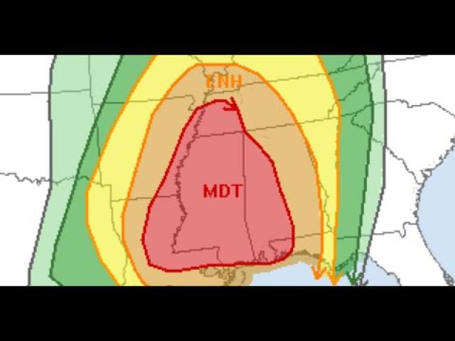
We've got a giant mixed bag of severe weather on our hands.
Stay aware & Be Prepared.
God bless everyone,
T
https://www.paypal.me/THORnews
@newTHOR on twitter
https://www.facebook.com/thornewsgo
Tshirts
https://hitthebuttonbaby.com/
the crankywxguy blog
http://www.stormhamster.com/entry/e020519.htm
stormhamster.com/snow.htm
mike's weather page
http://www.spaghettimodels.com/
models
https://www.tropicaltidbits.com/analysis/models/
a look at the Sun
https://sdo.gsfc.nasa.gov/data/
https://weather.com/safety/winter/news/2019-02-04-winter-storm-lucian-snow-ice-west-plains-midwest-northeast
Winter Storm Lucian Dumps Heavy Snow on the West and Will Spread a Mess of Snow and Ice Into the Midwest
Winter Storm Lucian is producing snow across the Mountain West.
Snow, sleet and freezing rain will spread across the Midwest through early Wednesday morning.
An ice storm warning is in effect for a portion of the Midwest, including Chicago.
Accumulating snow is expected in the northern Plains and upper Midwest.
A mix of snow, sleet and freezing rain will also affect upstate New York and New England.
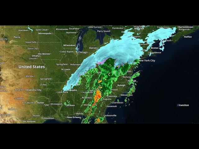
Winter Storm Lucian has already brought more heavy snow to the West and will now spread a mess of snow and potentially damaging ice across parts of the Plains, Midwest and interior Northeast through Thursday.
Happening Now
Lucian is producing several areas of snowfall across the Rockies, Great Basin and Sierra Nevada.
Farther east, snow, sleet and freezing rain from Lucian are increasing in parts of the Midwest and will expand eastward through early Wednesday morning.
Roads became covered in sleet in Rockford, Illinois, early Tuesday evening, leading to slick travel conditions for the evening commute. This area of sleet and freezing rain was expected to arrive in Chicago later Tuesday evening.
Sleet and freezing rain were accompanied by thunder at the National Weather Service office in Davenport, Iowa, Tuesday afternoon. In Muscatine, Iowa, penny-sized hail accumulated on vehicle tops, along with sleet and freezing rain.
Icy conditions from freezing drizzle contributed to accidents in the Wichita, Kansas, metro area early Tuesday.
The storm brought significant snow to Seattle on Monday. You can find a full recap on Lucian's history at the bottom of this article.
The National Weather Service has posted winter storm warnings and winter weather advisories across several states in the West.
In the Midwest, an ice storm warning is in effect through early Wednesday morning in parts of northern Illinois, including Chicago, as well as southeastern Iowa and far northeastern Missouri. This means ice could not only cause travel problems, but it may also damage trees and knock out power.
Winter weather advisories and winter storm warnings are also in effect in the Plains and Midwest from parts of northern Oklahoma to Michigan for snow, sleet or freezing rain. Winter weather advisories have also been posted in western and upstate New York and parts of New England. In those areas, travel could be hazardous due to icy conditions.
Snow will continue in the Mountain West, including in valley locations such as Salt Lake City.
Farther east, an initial wave of precipitation from this storm will break out over the Midwest and Great Lakes.
This will result in a band of freezing rain or sleet impacting an area from southern and eastern Kansas, western and northern Missouri and southeastern Iowa eastward to the southern Great Lakes, including Chicago, Milwaukee and Detroit.
Snow is expected from the Dakotas into Minnesota, northern and central Wisconsin and northern Michigan.
A broad area of snowfall may continue from the Rockies into the northern Plains and upper Midwest.
Increasing winds in the upper Midwest and northern Plains may lead to reduced visibility.
There will also be a band of freezing rain and sleet that extends across Lower Michigan, southern Wisconsin, parts of Iowa, northern and western Missouri and eastern Kansas.
Much of New England and parts of western and upstate New York could see freezing rain, sleet or snow by Wednesday or Wednesday night.
Snow and strong winds may continue to affect the upper Midwest and northern and western Great Lakes.
A band of sleet and freezing rain may extend from parts of Missouri to northern Lower Michigan.
Parts of New England and the higher terrain of upstate New York may also see a mix of snow, sleet and freezing rain.
Several inches of snow could accumulate through Thursday from the Dakotas and Nebraska into parts of northern Iowa, Minnesota, northern and central Wisconsin and northern Michigan.
The best chance for totals of 6 inches or more appears to be from the eastern Dakotas and northern Iowa into Minnesota, northern Wisconsin and the Upper Peninsula of Michigan.


Comments