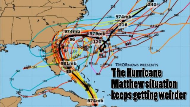
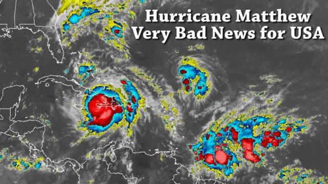
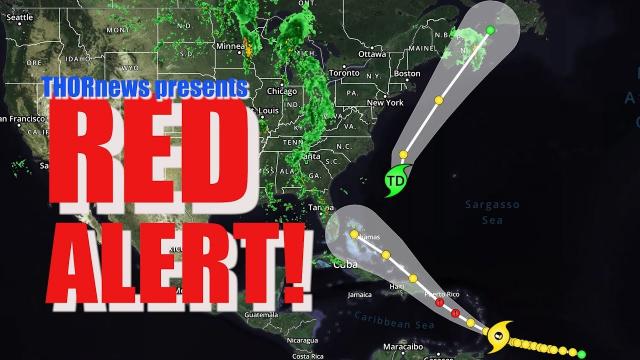
Alert! The Hurricane Situation is LIT! Florida & East COAST!
Description
The latest 06z drew up the North East Mid September Hurricane exactly as I've been drawing it up for months AND yesterday the GFS was still showing possible future threats to the Gulf of Mexico cities. So stay tuned to Peak Hurricane Season!
God bless everyone,
T LEWISON
5430 BIRDWOOD RD. #416
HOUSTON TEXAS 77096
HTTPS://WWW.PAYPAL.ME/THORNEWS
www.venmo.com/TEric-Lewison
$THORnews on CashApp
https://www.patreon.com/thornews
the crankywxguy blog (not me but good information)
http://www.stormhamster.com/entry2/e082319.htm
invest 98L
https://weather.com/storms/hurricane/news/2019-08-22-flooding-rain-southeast-florida-invest-98l-tropical-depression
A front will stall in the South as two tropical disturbances move toward the region.
Invest 98L is being monitored for development by the National Hurricane Center.
Locally heavy rain and flash flooding are possible through this weekend in parts of the South.
Heavy rain could trigger flooding in parts of the South through early next week as a stalling front interacts with moisture from a pair of tropical disturbances, including Invest 98L, which is being monitored for a chance of tropical development off the Southeast coast.
Watching For Tropical Development Off Southeast Coast
A weak area of low pressure located just east of the upper Florida Keys and the southeastern coast of the Florida Peninsula, tagged Invest 98L by the National Hurricane Center Thursday afternoon, is producing a large area of disorganized cloudiness and showers.
This system is forecast to move near or over Florida later Friday. When it emerges back over the Atlantic conditions may be conducive for tropical development this weekend or early next week as it moves near the coast of eastern Florida and the Southeast coast.
The National Hurricane Center has given it a high chance of development into a tropical depression or storm during the next five days. Those odds could increase or decrease during the next several days.
This is nothing to be overly concerned about for now, but it bears watching since we are in what is typically the hurricane season's busiest time of year. We'll provide more updates on weather.com in the days ahead.
Heavy Rain Across the South
A second area, currently located in the Gulf of Mexico, may need to be watched into early next week. This disturbance is producing an area of thunderstorms, but does not appear to be a tropical threat at this time.
These systems combined with a sagging cold front will bring periods of heavy rain into next week. The rain and thunderstorms will likely be more widespread than what the South experiences on a typical summer day.
Rainfall rates of an inch or more per hour are possible in the storms, so flash flooding is possible, particularly if the storms stall over the same area for multiple hours.
Many areas in the South could see 1 to 2 inches of rain through Tuesday from southern Louisiana into the Carolinas as well as portions of the Florida Peninsula. Localized heavier totals are likely in south Florida, along the southwestern Louisiana coast and near where the frontal boundary stalls.
Even after the two systems being watched for tropical development dissipate, we may need to watch this frontal boundary or its remnants. These boundaries are known to be a source of tropical cyclone development all by themselves on occasion. These recently occurred with the formation of Tropical Storm Chantal.
What Else We're Watching in the Atlantic
A tropical wave located about 1,400 miles east-southeast of the Windward Islands is also being watched for possible tropical development.
Showers and thunderstorms associated with this wave have increased and slow development of this system is possible over the next few days as it moves westward at about 15 mph.
The National Hurricane Center has given this system a low chance of development within the next five days, but these odds could change over the next couple of days. Check back to weather.com for updates on this system.


Comments